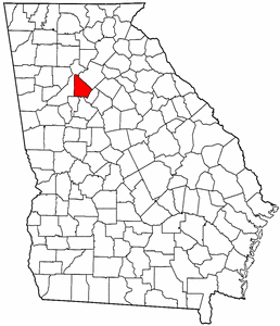
DeKalb County, Georgia
|
|
DeKalb County is a county located in the state of Georgia. As of 2000, the population is 665,865. The county's explosive growth is evident with a population of 675,725 according to the 2004 U.S. Census Estimate. The county's county seat is Decatur, Georgia6.
DeKalb is a part of the Atlanta Metropolitan Area.
| Contents |
History
DeKalb County was created in 1822 from Henry, Gwinnett and Fayette Counties. It was named for Baron Johann de Kalb, a German soldier who fought on the side of the Americans in the American Revolutionary War. In 1853, Fulton County was formed from part of DeKalb. Until this time, the growing city of Atlanta had been inside DeKalb. During the American Civil War, much of the Battle of Atlanta was fought in DeKalb. Until the 1960s, DeKalb was a mainly agricultural county, but as Atlanta and its suburbs grew, DeKalb became more urban.
Law and government
In 1984 DeKalb's state delegation created a CEO position (unique to DeKalb) who is the chief elected official. All employees report to the CEO rather than to commissioners, for day-to-day operations. The CEO serves as the chairman of the seven-member commission, but does not vote except to break a tie. The county commission is elected from five small districts and two super-districts that each make up half of the county and overlap the smaller districts.
Most of DeKalb makes up Georiga's 4th United States House of Representatives District.
Geography
According to the U.S. Census Bureau, the county has a total area of 702 km² (271 mi²). 695 km² (268 mi²) of it is land and 7 km² (3 mi²) of it is water. The total area is 1.00% water.
Demographics
As of the census2 of 2000, there are 665,865 people, 249,339 households, and 156,584 families residing in the county. The population density is 959/km² (2,483/mi²). There are 261,231 housing units at an average density of 376/km² (974/mi²). The racial makeup of the county is 35.82% White, 54.23% Black or African American, 0.23% Native American, 4.01% Asian, 0.05% Pacific Islander, 3.53% from other races, and 2.12% from two or more races. 7.89% of the population are Hispanic or Latino of any race.
There are 249,339 households out of which 31.00% have children under the age of 18 living with them, 40.10% are married couples living together, 17.60% have a female householder with no husband present, and 37.20% are non-families. 26.90% of all households are made up of individuals and 5.20% have someone living alone who is 65 years of age or older. The average household size is 2.62 and the average family size is 3.20.
In the county the population is spread out with 24.60% under the age of 18, 10.90% from 18 to 24, 36.70% from 25 to 44, 19.70% from 45 to 64, and 8.00% who are 65 years of age or older. The median age is 32 years. For every 100 females there are 94.10 males. For every 100 females age 18 and over, there are 90.80 males.
The median income for a household in the county is $49,117, and the median income for a family is $54,018. Males have a median income of $36,270 versus $31,653 for females. The per capita income for the county is $23,968. 10.80% of the population and 7.80% of families are below the poverty line. Out of the total population, 14.10% of those under the age of 18 and 8.70% of those 65 and older are living below the poverty line.
Cities and towns
- Atlanta (East Atlanta)
- Avondale Estates
- Chamblee
- Clarkston
- Collinsville (unincorporated)
- Decatur
- Doraville
- Druid Hills (unincorporated)
- Dunwoody (unincorporated)
- Lithonia
- Mechanicsville (unincorporated)
- North Atlanta (unincorporated)
- North Decatur (unincorporated)
- Panthersville (unincorporated)
- Philadelphia (unincorporated)
- Pittsburg (unincorporated)
- Pine Lake
- Redan (unincorporated)
- Scottdale (unincorporated)
- Stone Mountain
- Tucker (unincorporated)
- Turner Hill (unincorporated)

