Tonbridge and Malling
|
|
| Borough of Tonbridge and Malling | |
|---|---|
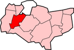
 Shown within Kent | |
| Geography | |
| Status: | Borough |
| Region: | South East England |
| Admin. County: | Kent |
| Area: - Total | Ranked 175th 240.13 km² |
| Admin. HQ: | West Malling |
| ONS code: | 29UP |
| Demographics | |
| Population: - Total (2003 est.) - Density | Ranked 192nd 109,612 456 / km² |
| Ethnicity: | 98.3% White |
| Politics | |
| Tonbridge and Malling Borough Council http://www.tmbc.gov.uk/ | |
| Leadership: | Leader & Cabinet |
| Executive: | Conservative |
| MPs: | Jonathan Shaw, John Stanley |
Tonbridge and Malling is a local government district and borough in Kent, England.
| Contents |
Location
Tonbridge and Malling borough covers an area from the North Downs at Burham and Snodland in the north to the town of Tonbridge in the south. The River Medway flows in a north easterly direction, through the borough towards the Medway Gap.
History
Ancient times
The area has been occupied for thousands of years. The Neolithic people left behind much evidence: megaliths such as Kits Coty at Aylesford and the Coldrum Stones at Trottiscliffe; and the Long Barrow at Aldington being examples. Bronze and Iron Age finds are also plentiful. So too is Romano-British: evidence is to be found all along the Medway Valley.
The immediate district of Tonbridge is omitted from the Domesday Book; however most other settlements in the Borough are included. Castles were built at Tonbridge, Allington and West Malling in the 13th century. Religious houses: Malling, Aylesford and Tonbridge were built: one such was St Mary's Abbey dating from 1092. Aylesford Priory on the banks of the Medway, was built in the 13th century.
Medieval manor houses can still be seen: Ightham Mote and Old Soar Manor being two of them.
19th century onwards
Description of the district
"Tonbridge district can be divided in two distinct areas, which were divided at the beginning of the nineteenth century by the woods and heaths of the ragstone (1) ridge from Great Comp to East Malling. Northwards lies the well peopled Holmesdale with the market town of West Malling as the principal centre of population, an area now crossed by the railway and motorway (M20); southwards of the ridge is the heavy clay of the Weald and valley of the Medway"
- extract from Kent Dr Felix Hull (An Ordnance Survey Historical Guide 1988)
- (1) Known as Kentish ragstone - geologically speaking Upper Greensand - and much used in church building throughout the county.
The modern district
Generally speaking, the district is mainly agricultural - orchards, and livestock in the main - although the proximity of the railways and the motorway means that there is a good deal of commuting from some of the more built-up villages. The new settlement of King's Hill is also a magnet for such commuting, since it provides a good deal of employment opportunity.
A remnant of the once flourishing hop-growing industry is provided by a tourist attraction at Beltring: once the Whitbread Hop Farm, it puts on frequent weekend exhibitions and shows of varying kinds. Here twenty-five of the finest examples of Victorian oast houses, once used for preparing hops for brewing.
At East Malling is a Research Station designed to "benefit research development and dissemination of useful results of such research in matters directly affecting horticultural crops generally with particular emphasis on the fruit, hop and nursery stock industries" (taken from website).
Many of the villages are located on the Tourist Trails designed, perhaps, to show the District more as being "scattered with picturesque villages, orchards and bluebell woods" instead of being a hard working area.
Local government
Tonbridge & Malling Council is based in Tonbridge and Kings Hill. The District is divided for political purposes, into 26 wards, including seven in the town of Tonbridge (called Cage Green, Castle, Higham, Judd, Medway, Trench and Vauxhall wards). The rural wards are:
- Aylesford
- Blue Bell Hill & Walderslade
- Borough Green & Lenham
- Ditton
- East Malling,
- East Peckham & Golden Green
- Hadlow, Mereworth & West Peckham
- Hildenborough
- Ightham
- Kings Hill
- Larkfield - two wards: North and South
- Snodland - two wards: East & West
- Wateringbury,
- West Malling & Leybourne
- Wrotham
In Parliament of the United Kingdom the area is covered by the larger Tonbridge and Malling Parliamentary Constituency.
Other villages in the District
Villages within those wards include:
- Addington: on the A20
- Birling: again on the A20
- Plaxtol
- Ryarsh: also on the A20. The first secretary of the Kent Archaelogical Society was vicar in Victorian times; the Ryarsh Brick Company is here.
- Shipbourne
- Stansted
- Trottiscliffe
- Wouldham
Population
In the 2001 census the population was 107,561.
References
Kent History Illustrated Frank W Jessup (KCC, 1966)

