Shepway
|
|
| Shepway District | |
|---|---|
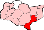
 Shown within Kent | |
| Geography | |
| Status: | District |
| Region: | South East England |
| Admin. County: | Kent |
| Area: - Total | Ranked 134th 356.70 km² |
| Admin. HQ: | Folkestone |
| ONS code: | 29UL |
| Demographics | |
| Population: - Total (2003 est.) - Density | Ranked 224th 98,159 275 / km² |
| Ethnicity: | 97.3% White 1.5% S.Asian |
| Politics | |
| Shepway District Council http://www.shepway.gov.uk/ | |
| Leadership: | Leader & Cabinet |
| Executive: | Liberal Democrats |
| MP: | Michael Howard |
Shepway is a local government district in Kent, England. It 'subtitles' itself as Folkestone, Hythe and Romney Marsh. It has council offices in Folkestone; and there are town councils in Hythe, New Romney and Lydd, with a parish council at Sandgate.
The district is divided into wards. Those wards - listing from north to south of the district - are Elham and Stelling Minnis; North Downs West and East (2 wards); Tolsford*; Folkestone; Lympne and Stanford; Hythe; Dymchurch and St Mary's; New Romney Town and Coast (2 wards); and Lydd. Romney Marsh ward is the entire inland portion of the district.
- Tolsford is an area of small villages below the North Downs and west of Folkestone. It is named after Tolsford Hill.
The motorway M20 and the Channel Tunnel Rail Link both cross the district: at Cheriton is the western end of the Tunnel.
External links
- District Council website (http://www.shepway.gov.uk)
- Community website for Shepway (http://www.shepwayonline.co.uk)

