East Sussex
|
|
| East Sussex | |
|---|---|

| |
| Geography | |
| Status: | Ceremonial & (smaller) Administrative County |
| Region: | South East England |
| Area: - Total - Admin. council - Admin. area | Ranked 33rd 1,792 km² Ranked 30th 1,709 km² |
| Admin HQ: | Lewes |
| ISO 3166-2: | GB-ESX |
| ONS code: | 21 |
| NUTS 3: | UKJ22 |
| Demographics | |
| Population: - Total (2003 est.) - Density - Admin. council - Admin. pop. | Ranked 28th 747,540 416 / km² Ranked 26th 496,082 |
| Ethnicity: | 96.5% White 1.0% S.Asian |
| Politics | |
| East Sussex County Council http://www.eastsussexcc.gov.uk/ | |
| Executive: | Conservative |
| Members of Parliament | |
|
Norman Baker, Gregory Barker, Celia Barlow, Michael Foster, Charles Hendry, David Lepper, Desmond Turner, Nigel Waterson | |
| Districts | |
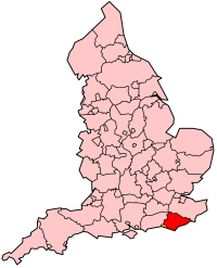
East Sussex is a county in South East England. It is bordered by the counties of Kent, Surrey and West Sussex and, to the south, by the English Channel.
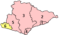
The ancient kingdom of Sussex was divided into eastern and western administrative regions, with separate county councils, in 1888: the county town became Lewes. In the new Sussex East county there were three self-administered county boroughs: Brighton, Eastbourne and Hastings. In 1974 the new county of East Sussex was created: at which point the three county boroughs became districts within the county. At the same time the western boundary was altered, so that the Mid Sussex region (including Burgess Hill and Haywards Heath) was transferred to the administrative county of West Sussex.
In 1997, Brighton & Hove became a self administered unitary authority and was eventually granted city status in 2000.
| Contents |
Geography
The South Downs, a range of moderate chalk hills, run across the southern part of the county from west to east. The northern part of the county is dominated by the High Weald, and in between runs the valley of the River Rother (also known as the River Limen).
The highest point in the county is Ditchling Beacon, at 248m/814ft. It is also a Marilyn.
Towns and villages
Note that the website Villagenet contains details (including historical) of 240 villages in East Sussex, including some that are noted below. http://www.villagenet.co.uk/
See the list of places in East Sussex.
Places of interest
- Ashdown Forest
- Batemans
- Beachy Head
- Bodiam Castle
- Ditchling Common
- Heritage railways: Bluebell Railway, Lavender Line Steam Railway, Kent & East Sussex Railway
- Herstmonceux
- South Downs Way, a long distance footpath
- University of Sussex
See also
| United Kingdom | England | Ceremonial counties of England | 
|
|
Bedfordshire | Berkshire | City of Bristol | Buckinghamshire | Cambridgeshire | Cheshire | Cornwall | Cumbria | Derbyshire | Devon | Dorset | Durham | East Riding of Yorkshire | East Sussex | Essex | Gloucestershire | Greater London | Greater Manchester | Hampshire | Herefordshire | Hertfordshire | Isle of Wight | Kent | Lancashire | Leicestershire | Lincolnshire | City of London | Merseyside | Norfolk | Northamptonshire | Northumberland | North Yorkshire | Nottinghamshire | Oxfordshire | Rutland | Shropshire | Somerset | South Yorkshire | Staffordshire | Suffolk | Surrey | Tyne and Wear | Warwickshire | West Midlands | West Sussex | West Yorkshire | Wiltshire | Worcestershire |
External links
- Information on Sussex, history, maps (http://www.britishcounties.info/sussex/)
- East Sussex County Council (http://www.eastsussex.gov.uk/)
de:East Sussex
eo:East Sussex
es:East Sussex
no:East Sussex
sv:East Sussex

