Lake Tahoe
|
|
- Tahoe redirects here. For the SUV, see Chevrolet Tahoe.
Lake_tahoe_and_hotels_1908.jpg
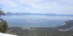
Lake Tahoe is one of the deepest (1645 feet/501 m), largest (192 sq. mi./497 km²), highest (6229 feet/1898 m), and bluest lakes in the United States. Only Oregon's Crater Lake is bluer and deeper at 1930 feet (588 m). Lake Tahoe is in the Sierra Nevada mountains, on the border between California and Nevada, with approximately two-thirds of the shoreline in California.
Prior to the silver strike in Virginia City, Nevada in the 1860s the only people that inhabited the Tahoe area were the Native American tribe known as the Washoe. During the silver strike thousands of trees were turned into beams for supporting the mines in Virginia City. Mark Twain spent time at Lake Tahoe during this time and included the experience in his travel memoir, Roughing It.
Today, the area surrounding Lake Tahoe is full of restaurants, ski slopes and wooded homes, and casinos. As gambling is legal on the Nevada side of the lake, the resort area of Lake Tahoe attracts all kinds of fun seekers, year round. During ski season, thousands of people from all over California, including Los Angeles, San Francisco, and San Jose, flock to the slopes or the shore. During the summer, the lake is popular for water sports and beach activities. The two cities most identified with the Lake Tahoe tourist area are South Lake Tahoe, California and the smaller Stateline, Nevada; smaller centers on the California shoreline include Tahoe City and Kings Beach.
Lake Tahoe has suffered from so much use. Until recently construction on the banks of the Lake had been, more or less, under the control of wealthy real estate developers. Construction activities had been linked to a 'clouding' of the amazingly blue waters of the Lake. A court injunction has stopped all new construction until new rules that ensure the protection of the lake over the interests of individuals are in place. Although for much of its circumference, highways run within sight of the lake shore, some important parts of the California shoreline now lie within state parks or are protected by the United States Forest Service. Nevada seems to have been less active, or less successful, in its conservation efforts.
By 1970, the lake had started to show signs of eutrophication, which would wreck the pristine beauty that attracts tourists. To combat this, the local cities installed a quite-exotic tertiary sewage treatment plant. Despite this, the lake is still losing an average of one and a half feet of clarity per year due to development and associated erosion problems, runoff from pavement, and fertilizer usage on the lake shore.
Although Lake Tahoe is a natural lake, it is also used for water storage by the Truckee-Carson Irrigation District (TCID). The lake level is controlled by a dam at the lake's only outlet, the Truckee River, at Tahoe City.
The Reno/Tahoe International Airport in Reno, Nevada and the Chevrolet Tahoe SUV were named after the lake.
See also
External links
- Lake Tahoe Data Clearinghouse (http://tahoe.usgs.gov/) - USGS/Western Geographic Science Center
- Tahoe Regional Planning Agency (http://www.trpa.org/)
- Lake Tahoe Watershed (http://endeavor.des.ucdavis.edu/newcara/basin.asp?cara_id=56)- California Rivers Assessment database
- Lake Tahoe Basin Management Unit (http://www.fs.fed.us/r5/ltbmu/) - USDA Forest Service
- Lake Tahoe Photographs (http://www.flickr.com/groups/tahoe/) - Lake Tahoe group at Flickr
- League to Save Lake Tahoe (http://www.keeptahoeblue.org) -environmental watchdog organization
| Nevada | 
|
|---|---|
| Regions: Great Basin | Mojave Desert | Lake Tahoe | Las Vegas Valley | |
| Largest cities: Carson City | Henderson | Las Vegas | North Las Vegas | Reno | Sparks | |
| Counties: Churchill | Clark | Douglas | Elko | Esmeralda | Eureka | Humboldt | Lander | Lincoln | Lyon | Mineral | Nye | Pershing | Storey | Washoe | White Pine | |


