Berkeley, California
|
|
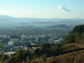
Berkeley is a city in the San Francisco Bay Area of northern California, United States. Its neighbor to the south is the city of Oakland, California. Its eastern border is formed by the Tilden Regional Park. Berkeley is located in Alameda County. Home to the University of California, Berkeley, the city is known for its leftist politics, eclectic mix of residents, and gourmet food.
Berkeley_in_Alameda_County.png
| Contents |
Places
Berkeley is the site of the University of California, Berkeley, the flagship campus of the University of California, and the Lawrence Berkeley National Laboratory, Lawrence Hall of Science, Space Sciences Laboratory, and Mathematical Sciences Research Institute, which are on the campus grounds. Another well known educational institution in Berkeley is the Graduate Theological Union.
Other notable places include:
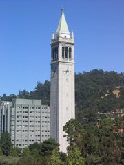
- The Campanile belltower (Sather Tower) in the University of California, Berkeley campus
- The large red Tuning Fork Sculpture in downtown Berkeley on Shattuck Avenue
- The bicycle-pedestrian bridge across I-80 at University Avenue, the first of a new generation of people-friendly transportation improvements that focus on access instead of cars
- Telegraph Avenue, along with People's Park (http://www.peoplespark.org/), known as a center for "hippie" activity during the 1960's-70's, marijuana, and now the several "old timers" left over from the age
- The Claremont Resort & Spa (http://www.claremontresort.com/)
- The critically acclaimed restaurant, Chez Panisse
- Berkeley Rose Garden
Main streets include:
- Shattuck Avenue, home to the downtown business district, and the Gourmet Ghetto to the north
- Telegraph Avenue
- Solano Avenue, in the Thousand Oaks neighborhood
- Martin Luther King Junior Way
- 4th Street, with a small area of more expensive commercial services, including Bette's Ocean View Diner (http://www.worldpantry.com/bettes/home.html), and several salons and women's clothing stores
- University Avenue, including the Indian business districts
- College Avenue, the main commerce area being in the Elmwood Neighborhood. It continues into the Rockridge Area of Oakland, California
- San Pablo Avenue, in West Berkeley
History
The history of the city is inextricably linked to its university. According to the Centennial Record of the University of California, "In 1866...at Founders' Rock, a group of College of California men were watching two ships standing out to sea through the Golden Gate. One of them, Frederick Billings, was reminded of the lines of Bishop Berkeley, 'westward the course of empire takes its way,' and suggested that the town and college site be named for the eighteenth-century British philosopher and poet." In 1873, Governor Newton Booth declared Berkeley to be the "Athens of the West".
The University of California first operated in Berkeley in 1872. Much of Berkeley's economy, status, and reputation has long derived from its relationship with the institution. The Pacific School of Religion (PSR), was founded by Congregationalists in 1866 as an ecumenical theological school the first graduate seminary west of the Mississippi, and one of the two largest religious schools in the world (the other is in Leuven, Belgium). As a result, Berkeley is reputed to have the most churches per capita of any city in the US.
The 1910 "First Church of Christ, Scientist", designed by Bernard Maybeck, is a mix of Craftsman, Gothic, and Romanesque styles. It is a National Historic Landmark.
Both city and university have long been famed as a center of activist politics and radical social ideas. Early in the twentieth century, West Berkeley became a center for Finnish immigrants, many of whom were Socialists, and who contributed to the growing labor movement in the 1920s and 30s. The Finnish Hall (Toveri Tupa) in the 1800 block of Tenth Street is a now-landmarked community meeting place built by these Finnish activists in 1908. In 1911, Berkeley had a Socialist mayor, J. Stitt Wilson. The movement for women's suffrage was strong in Berkeley. In 1911, when it became law, California became the sixth state in the US to allow women to vote. While surrounding Alameda County as a whole voted against the female right to vote, it won easily in Berkeley.
In the late 1920s several large women's organizations combined to form the Berkeley Women's City Club. Its beautiful Italianate building on Durant Avenue, designed by renowned Hearst Castle architect Julia Morgan and completed in 1930, is a Berkeley landmark. Today Berkeley has one of the still relatively few female fire chiefs in the US, Deborah Pryor, an African-American.
The Free Speech Movement began on the Berkeley campus, arguing for free speech on campus, despite its ownership by the Regents. Many student demonstrations against the Vietnam War occurred there in the 1960s, which American news organizations dramatically televised.
Another notable series of events that helped to solidify this popular conception of Berkeley is the repeated takeover by populists of an open lot owned by the University of California. The University has long sought to build on the lot, but the populists have demanded that the lot remain undeveloped and open as a public park. Today this lot is called People's Park and 1960s era culture and spirit still lives on Telegraph Avenue.
Due to the generally liberal to radical views of the Berkeley public, the city is sometimes mockingly referred to as the People's Republic of Berkeley (and have led some to deride it as "Berzerkley"). This reputation—along with its generally temperate weather, high rates of tourism, and large student population—have attracted large populations of transient people, many of whom are homeless. As a result from this large homeless population, and proximity to high-poverty areas of Oakland, California, had resulted in crime rates which per capita are often among the top in the state. Berkeley's police department, under August Vollmer, the first chief, was the first in the US to require that officers have a college degree, early in the 20th century. This department developed the lie detector test, and was one of the first to use fingerprints and radios.
In 1973, Berkeley's city council enacted its well known Berkeley Marijuana Initiative. The act ordered Berkeley police to make "no arrests and issue no citations for violations of marijuana laws."
In 1986 Berkeley officially became a Nuclear Free Zone after a local vote, disallowing the operation of nuclear reactors within city limits and preventing work from being done on nuclear weapons within its borders. While this can be seen as a logical extension of its radicalism, it also is an ironic play with Berkeley's past: the University of California, Berkeley played a major role in the development of nuclear weapons during World War II, a DOE National Laboratory (Lawrence Berkeley National Laboratory) still sits in the expensive hill-side real estate above the city. The University of California, as of this writing, still has a contract with the U.S. government to manage LBNL, Los Alamos National Laboratory, and Lawrence Livermore National Laboratory (the latter of which designed all nuclear warheads in the U.S. arsenal, and still maintain the programs of stockpile stewardship). Street signs posted at the city borders declaring its Nuclear Free Zone status are the most noticeable effect of the measure. (The University also once housed a small research reactor which would have been in noncompliance with the Nuclear Free Berkeley Act. This was replaced in the 1990s with a computer laboratory, though the University denies that this had anything to do with the Act).
The city of Berkeley is home to a number of well-known artists, architects, composers, writers and thinkers: Fritjof Capra, Susan Griffin, Christopher Alexander, John Adams, Rita Moreno, Michael Parenti, Michael Lerner, Michael Chabon, and others. The city also has more independent publishers per capita than any other city in the country, and more bookstores per capita.
More recently, Berkeley has become known as a gourmet food center. Even by the standards of the Bay Area it has an exceptional number of specialist food shops and restaurants, the Berkeley Bowl Supermarket (http://www.berkeleybowl.com/), and a Berkeley restaurant, Chez Panisse, is regarded as the birthplace of California cuisine. Its proprietor, Alice Waters, has been called "the mother of American cooking."
Since the 1970s, the Bay Area Rapid Transit system (BART), a metro train system, has linked Berkeley to San Francisco and the other cities of the Bay Area. Berkeley has nevertheless maintained its own character. Originally the planners of BART proposed an above-ground route through Berkeley, but Berkeley residents voted for a below-ground tunnel route instead, whose extra cost was funded by a bond issue. Consequently, BART runs entirely in an underground tunnel through Berkeley, but above ground in the neighboring city of Albany.
Humorous saying: "Three things have come out of Berkeley: LSD, BSD, and the SCA. This is no coincidence."
Interestingly, fewer people live in Berkeley today than did 55 years ago. Few other cities in the western United States can make this claim:
Population by decade:
- 1890 - 5,101
- 1900 - 13,214
- 1910 - 40,434
- 1920 - 56,036
- 1930 - 82,109
- 1940 - 85,547
- 1950 - 113,805
- 1960 - 111,268
- 1970 - 116,716
- 1980 - 103,328
- 1990 - 102,724
- 2000 - 102,743
Geography
CAMap-doton-Berkeley.png
Location of Berkeley, California
According to the United States Census Bureau, the city has a total area of 45.9 km² (17.7 mi²). 27.1 km² (10.5 mi²) of it is land and 18.8 km² (7.2 mi²) of it is water. The total area is 40.94% water.
Berkeley borders the cities of Albany, Oakland, and Emeryville and unincorporated Contra Costa County including Kensington as well as San Francisco Bay.
Demographics
Telegraph-Ave-Berkeley.jpg
The city's population is culturally diverse, with a significant portion in transient residence to attend the university. As of the censusTemplate:GR of 2000, there are 102,743 people, 44,955 households, and 18,656 families residing in the city. The population density is 3,792.5/km² (9,823.3/mi²), one of the highest in California. There are 46,875 housing units at an average density of 1,730.3/km² (4,481.8/mi²). The racial makeup of the city is 59.17% White, 13.63% Black or African American, 0.45% Native American, 16.39% Asian, 0.14% Pacific Islander, 4.64% from other races, and 5.57% from two or more races. 9.73% of the population are Hispanic or Latino of any race.
There are 44,955 households out of which 17.8% have children under the age of 18 living with them, 28.9% are married couples living together, 9.5% have a female householder with no husband present, and 58.5% are non-families. 38.1% of all households are made up of individuals and 7.9% have someone living alone who is 65 years of age or older. The average household size is 2.16 and the average family size is 2.84.
In the city the population is spread out with 14.1% under the age of 18, 21.6% from 18 to 24, 31.8% from 25 to 44, 22.3% from 45 to 64, and 10.2% who are 65 years of age or older. The median age is 32 years. For every 100 females there are 96.5 males. For every 100 females age 18 and over, there are 95.1 males.
The median income for a household in the city is $44,485, and the median income for a family is $70,434. Males have a median income of $50,789 versus $40,623 for females. The per capita income for the city is $30,477. 20.0% of the population and 8.3% of families are below the poverty line. Out of the total population, 13.4% of those under the age of 18 and 7.9% of those 65 and older are living below the poverty line.
Transportation
Berkeley is served by Amtrak, Bay Area Rapid Transit (BART), AC Transit and several employer shuttles. The only major freeway is Interstate 80. Despite the fact that all students at the University of California, Berkeley receive a free AC Transit bus pass, each day there is an influx of thousands of cars into the city by commuting UC faculty, staff and students, making parking for more than a few hours an expensive proposition.
Berkeley has one of the highest rates of bicycle and pedestrian commuting in the nation. Berkeley is the safest city of its size for pedestrians and cyclists, a fact that new research is attributing to a safety in numbers (http://www.tsc.berkeley.edu/html/newsletter/Spring04/syntax.html) effect. [Prior widely published data from the California Office of Traffic Safety had failed to account for levels of use. Compared to other similar California cities, Berkeley has four times the injury rate per 1,000 population, but six times the number of cyclists.]
Berkeley has modified its original grid roadway structure through use of diverters and barriers, moving most traffic out of neighborhoods and onto arterial streets (visitors often find this confusing, because the diverters are not shown on all maps). Berkeley maintains a separate grid of arterial streets, Bicycle Boulevards, where conditions, in theory, have been tweaked to favor bicycle travel.
Berkeley hosts a car sharing network run by City CarShare (http://www.citycarshare.org/). Rather than owning (and parking) their own cars, members share a group of cars parked nearby. Online reservation systems keep track of hours and charges.
Mayors
- Loni Hancock, mayor who married California State Assembly Representative Tom Bates
- Shirley Dean, mayor 1995–2002
- Tom Bates, current Mayor of Berkeley (2003–), who is married to California State Assembly Representative Loni Hancock
Points of interest
- Berkeley Repertory Theatre
- Chez Panisse
- Cloyne Court Hotel
- Fantasy Records
- Lawrence Berkeley National Laboratory
- Regional Parks Botanic Garden
- University of California, Berkeley
- University of California Botanical Garden
External links
- City of Berkeley official web page (http://www.ci.berkeley.ca.us/)
- People's Park (http://www.peoplespark.org/)
- Homeless Youth Shelter (http://www.yeah-berkeley.org/)
- Berkeley Firefighters Association (http://www.bffa1227.org/)
- Photos of Berkeley (http://www.terragalleria.com/california/california.berkeley.html)
- The Daily Californian (http://www.dailycal.org/)
- The Berkeley Language Center (http://blc.berkeley.edu/)
Template:Cities of Alameda County, California
bg:Бъркли
da:Berkeley, Californien
de:Berkeley (Kalifornien)
es:Berkeley (California)
fr:Berkeley (Californie)
ja:バークリー (カリフォルニア州)
pl:Berkeley
sv:Berkeley, Kalifornien


