Idaho
|
|
| |||||
| State nickname: Gem State | |||||

| |||||
| Other U.S. States | |||||
| Capital | Boise | ||||
| Largest city | Boise | ||||
| Governor | Dirk Kempthorne | ||||
| Official languages | none | ||||
| Area | 216,632 km² (14th) | ||||
| - Land | 214,499 km² | ||||
| - Water | 2,133 km² (0.98%) | ||||
| Population (2000) | |||||
| - Population | 1,293,953 (39th) | ||||
| - Density | 6.04 /km² (44th) | ||||
| Admission into Union | |||||
| - Date | July 3, 1890 | ||||
| - Order | 43rd | ||||
| Time zone | Pacific: UTC-8/-7 (northern) Mountain: UTC-7/-6 (southern) | ||||
| Latitude | 42? N to 49? N | ||||
| Longitude | 111? W to 117? W | ||||
| Width | 491 km | ||||
| Length | 771 km | ||||
| Elevation | |||||
| - Highest | 3,859 m | ||||
| - Mean | 1,524 m | ||||
| - Lowest | 216 m | ||||
| Abbreviations | |||||
| - USPS | ID | ||||
| - ISO 3166-2 | US-ID | ||||
| Web site | www.idaho.gov | ||||
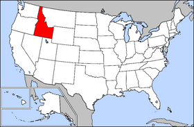
Idaho is a state located in the northwestern United States. Its capital is Boise and the U.S. postal abbreviation is ID.
The USS Idaho was named in honor of this state.
| Contents [hide] |
Name
Idaho is perhaps the only state to be named as the result of a hoax. When a name was being selected for new territory, eccentric lobbyist George M. Willing suggested "Idaho," an Indian term he claimed meant "gem of the mountains." It was later revealed Willing had made up the name himself, and the original Idaho territory was re-named Colorado because of it. Eventually the controversy was forgotten, and modern-day Idaho was given the made-up name when the Idaho Territory was formally created in 1863.
History
The Lewis and Clark expedition entered present-day Idaho on August 12, 1805, at the Lemhi Pass. At that time, approximately 8,000 Native Americans lived in the region.
Idaho was subsequently part of Oregon Territory and later Washington Territory, fur trading and missionary work attracting the first settlers to the region. While thousands passed through Idaho during the California gold rush of 1849, few people settled there. The first organized town in Idaho was Franklin, settled in 1860 by Mormon pioneers. When organized as a territory in 1863, Idaho's total population was under 17,000.
On March 4, 1863, President Abraham Lincoln signed an act creating Idaho Territory. The political stability of the territorial period encouraged settlement. Almost immediately, a public school system was created, stage coach lines were established and a newspaper, the Idaho Statesman, began publication. In 1865, Boise replaced Lewiston as capital. The 1861 discovery of gold in Idaho and the completion of the transcontinental railway in 1869 brought many new people to the territory, including Chinese laborers who came to work the mines. When President Benjamin Harrison signed the law admitting Idaho as a U.S. state on July 3, 1890, the population was 88,548. An interesting fact is that Idaho almost never became a state - in 1887, President Grover Cleveland refused to sign a bill that would have combined southern Idaho with Nevada and northern Idaho with the Washington Territory. Sectionalism in early Idaho was abated by moving the University of Idaho from its planned location in Eagle Rock (near Idaho Falls) to Moscow in northern Idaho. Idaho still operates under its original (1889) state constitution.
As Idaho approached statehood, mining and other extractive industries became increasingly important to her economy. By the 1890s, for example, Idaho exported more lead than any other state. Although Idaho's dependence on mining has decreased, the state remains a top producer of silver and lead. Today, Idaho's industrial economy is growing, as plants are built to process the state's rich agricultural and natural resources. Since in the late 1970s Boise has emerged as a center of semiconductor manufacturing. Boise is the home of Micron Technology Inc., the only U.S. manufacturer of dynamic random access memory (DRAM) chips. Hewlett-Packard has operated a large plant in Boise, in southwestern Idaho, since the 1970s, devoted primarily to LaserJet printers.[1] (http://memory.loc.gov/ammem/today/mar04.html)
A troubling recent development in the Idaho panhandle region has been the location therein of a few right-wing extremist and "survivalist" political groups, most notably one holding Neo-Nazi views, the Aryan Nations. These groups are most heavily concentrated in the northern part of the state, particularly in the vicinity of Coeur d'Alene, a resort town. Although Idaho is a conservative state politically, the vast majority of its residents reject such hateful ideologies. Boise recently installed an impressive stone Human Rights Memorial featuring quotations from Anne Frank and many other writers extolling human freedom and equality. In 2002 the Aryan Nations compound, which had been located in Hayden Lake, Idaho, was confiscated as a result of a court case, and the organization moved out of state.
Law and government
State government
The current Governor of Idaho is Dirk Kempthorne (Republican), re-elected in 2002.
The constitution of Idaho provides for 3 branches of government: the executive, legislative and judicial branches. Idaho has a bicameral legislature, elected from 35 legislative districts, each represented by one Senator and two Representatives.
Federal government
United States Senators:
- Larry E. Craig (Republican)
- Mike Crapo (Republican)
House of Representatives: Idaho has two House Representatives
- 1st District: C.L. "Butch" Otter (Republican)
- 2nd District: Mike Simpson (Republican)
Geography
National-atlas-idaho.PNG
Owyhee_Mountains.jpg
Idaho borders Washington, Oregon, Nevada, Utah, Montana, Wyoming and the Canadian province of British Columbia (the Idaho-BC border which is 48 miles long). Idaho has a rugged landscape with some of the largest unspoiled natural areas in the country. Idaho is a Rocky Mountains state with exciting scenery and enormous natural resources. Idaho has towering, snow-capped mountain ranges, swirling white rapids, peaceful lakes and steep canyons. The churning waters of Snake River rush through Hells Canyon, which is deeper than the Grand Canyon. Shoshone Falls plunges down rugged cliffs from a height greater than that of Niagara Falls.
The major rivers in Idaho are the Snake River, the Clearwater River and the Salmon River. Other significant rivers include the Boise River and the Payette River.
Idaho's highest point is Borah Peak in the Lost River Mountains north of Mackay. Idaho's lowest point is in Lewiston, where the Clearwater River joins the Snake River and continues into Washington.
Lakes
|
|
Parks
|
Economy
The state's gross product for 2003 was $40 billion. The Per Capita Income for 2003 was $25,902.
Idaho is an important agricultural state, producing nearly one third of the potatoes grown in the United States. Other important agricultral products are beans, lentils, sugar beets, cattle, dairy products, wheat, and barley.
Important industries in Idaho are food processing, lumber and wood products, machinery, chemical products, paper products, electronics manufacturing, silver and other mining, and tourism. The Idaho National Laboratory (INL), a government lab for nuclear energy research, is also an important part of the eastern Idaho economy.
Demographics
As of 2003, the population of Idaho was 1,366,332.
The racial makeup of Idaho is:
- 88% White
- 7.9% Hispanic
- 1.4% American Indian
- 0.9% Asian
- 0.4% Black
- 2% Mixed race
The five largest ancestries in the state are: German (18.9%), English (18.1%), Irish (10%), American (8.4%), Norwegian (3.6%).
Religion
As with many other western states, the percentage of non-religious people in Idaho is fairly high when compared to the percentage of non-religious in the nation as a whole. Idaho is also the only state to have large numbers of both Mormons and non-Mormon Christians.
The religious affiliations of Idaho are as follows:
- Christian — 80%
- Protestant — 48%
- Baptist — 10%
- Methodist — 10%
- Lutheran — 3%
- Presbyterian — 3%
- Other Protestants/general Protestants — 22%
- Catholic — 16%
- Mormon — 16%
- Protestant — 48%
- Non-Christian Religions — <1%
- Non-Religious — 20%
Important cities and towns
|
Population > 100,000 (urbanized area) (state capital) |
Population > 10,000 (urbanized area) |
Smaller Towns and Cities
|
Education
Colleges and universities
Professional sports teams
The Minor League baseball teams are:
Other minor league sports teams:
Miscellaneous information
Major highways
Well-known Idahoans
See also
- Red Rock Pass - The pass where the ancient Lake Bonneville was emptied.
Clip Art and Pictures
- Free Clipart (http://classroomclipart.com)
State Maps
- US State Maps (http://classroomclipart.com/cgi-bin/kids/imageFolio.cgi?direct=Clipart/US_State_Maps)
- Printable Black and White Map of Idaho (http://www.lessonplancentral.com/statemaps/idaho_state_mapBW.jpg)
State Flags
- US State Flags (http://classroomclipart.com/cgi-bin/kids/imageFolio.cgi?direct=Clipart/State_Flags)
Lesson Plans, Resources and Activites
- Lesson Plan Central (http://lessonplancentral.com)
- Idaho Lesson Plans (http://lessonplancentral.com/lessons/Social_Studies/State_Facts/Idaho/index.htm)
External links
- http://www.state.id.us/
- Idaho State Information (http://www.eachtown.com/state_info.php/stateid/13)
- Visit Idaho site (http://www.visitid.org/)
- A photographic virtual tour of Idaho (http://www.Untraveledroad.com/USA/Idaho.htm)
- US Census Bureau (http://quickfacts.census.gov/qfd/states/16000.html)
- Idaho Newspapers (http://www.usnewspapers.org/state/idaho)
| Regions of Idaho | 
|
|---|---|
| Rocky Mountains | Columbia River Plateau | Inland Empire | Basin and Range Province | |
| Boise metropolitan area | Treasure Valley | Idaho Panhandle | Magic Valley | |
| Largest cities | |
| Blackfoot | Boise | Burley | Caldwell | Chubbuck | Coeur D'Alene | Eagle | Garden City | Hayden | Idaho Falls | Lewiston | Meridian | Moscow | Mountain Home | Nampa | Pocatello | Post Falls | Rexburg | Twin Falls | |
| Counties | |
| Ada | Adams | Bannock | Bear Lake | Benewah | Bingham | Blaine | Boise | Bonner | Bonneville | Boundary | Butte | Camas | Canyon | Caribou | Cassia | Clark | Clearwater | Custer | Elmore | Franklin | Fremont | Gem | Gooding | Idaho | Jefferson | Jerome | Kootenai | Latah | Lemhi | Lewis | Lincoln | Madison | Minidoka | Nez Perce | Oneida | Owyhee | Payette | Power | Shoshone | Teton | Twin Falls | Valley | Washington | |
| Political divisions of the United States | 
| ||||||
|---|---|---|---|---|---|---|---|
| |||||||


