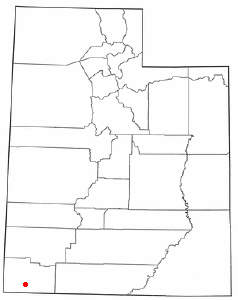
St. George, Utah
|
|
Palmut.jpg
St. George is the population and commercial center of Utah's Dixie, a region so named when Mormon pioneers grew cotton in the area. It's one of the warmest parts of the state of Utah, in sharp contrast to nearby Cedar City, which is considerably cooler. St. George's trademark is its geology -- red bluffs frame the northern part of the city, and the eastern edges of the Mojave Desert are visible to the south. Zion National Park can be seen to the east, and large mountains are nearby to the north and southeast.
| Contents |
History
St. George was founded in the 1850s by direction of the president of the LDS (Mormon) church, Brigham Young as a cotton misson - part of a greater effort of the church to become self-sufficient. While the early settlers did manage to produce cotton, it was never able to produce it at a competitive market rate, and so was abandoned after many years.
May 19, 1953 – The United States government detonated the 32-kiloton of TNT (130 TJ) bomb "Harry" at the Nevada test site. The bomb later gained the name "Dirty Harry" because of the tremendous amount of offsite fallout generated by the bomb. [1] (http://www.commondreams.org/views03/0526-05.htm) Winds carried fallout 135 miles (220 km) to St. George, Utah, where residents reported "an oddly metallic sort of taste in the air." [2] (http://www.ratical.org/radiation/KillingOurOwn/KOO3.html) A 1962 AEC report found that "children living in St. George, Utah may have received doses to the thyroid of radioiodine as high as 120 to 440 rads" (1.2 to 4.4 Gy).[3] (http://www.thebulletin.org/issues/1997/nd97/nd96ortmeyer.html)
St. George was the location of the 1998 United States Academic Decathlon national finals.
The city began booming in the mid-1980s, first as a retirement hotspot and tourist gateway to Utah's Color Country, then as a major transportation center. Many companies, including Wal-Mart, have distribution centers in the St. George area. The city is on the I-15 corridor, just a few hours' drive from the western terminus of I-70, as well as access to the I-10 and I-40 corridors via nearby US 93.
Education
St. George is home to Dixie State College of Utah, a four-year institution. Community growth has led to planning of a new regional airport for St. George, as well as a beltway around the western, northern, and southern parts of the urban area.
Geography
St. George is located at 37°5'43" North, 113°34'41" West (37.095279, -113.578151)Template:GR.
According to the United States Census Bureau, the city has a total area of 168.0 km² (64.9 mi²). 166.8 km² (64.4 mi²) of it is land and 1.2 km² (0.5 mi²) of it is water. The total area is 0.72% water.
Demographics
As of the censusTemplate:GR of 2000, there are 49,663 people, 17,367 households, and 13,042 families residing in the city. The population density is 297.7/km² (771.2/mi²). There are 21,083 housing units at an average density of 126.4/km² (327.4/mi²). The racial makeup of the city is 92.27% White, 0.24% African American, 1.64% Native American, 0.57% Asian, 0.59% Pacific Islander, 2.87% from other races, and 1.83% from two or more races. 6.72% of the population are Hispanic or Latino of any race.
There are 17,367 households out of which 34.2% have children under the age of 18 living with them, 63.6% are married couples living together, 8.6% have a female householder with no husband present, and 24.9% are non-families. 19.4% of all households are made up of individuals and 10.2% have someone living alone who is 65 years of age or older. The average household size is 2.81 and the average family size is 3.21.
In the city the population is spread out with 28.4% under the age of 18, 13.7% from 18 to 24, 22.0% from 25 to 44, 16.8% from 45 to 64, and 19.3% who are 65 years of age or older. The median age is 31 years. For every 100 females there are 94.5 males. For every 100 females age 18 and over, there are 91.2 males.
The median income for a household in the city is $36,505, and the median income for a family is $41,788. Males have a median income of $31,106 versus $20,861 for females. The per capita income for the city is $17,022. 11.6% of the population and 7.4% of families are below the poverty line. Out of the total population, 14.4% of those under the age of 18 and 4.4% of those 65 and older are living below the poverty line.
Famous People from St.George
- Doug Jolley-NFL tight end
External links
- Official web site of the City of St. George, Utah (http://www.sgcity.org/)
Template:Geolinks-US-cityscale

| |
|---|---|
| State Capital: | |
| Regions: |
Dixie | Great Salt Lake | Great Salt Lake Desert | Uinta Mountains | Wasatch Front | Wasatch Back | Wasatch Range |
| Major Metros: |
Ogden | Provo | Saint George | Salt Lake City |
| Suburbs: |
Bountiful | Clearfield | Draper | Layton | Midvale | Murray | Orem | Roy | Sandy | Taylorsville | West Jordan | West Valley City |
| Smaller Cities: |
Brigham City | Cedar City | Logan | Moab | Park City | Price | Richfield | Tooele | Vernal |
| Counties: |
Beaver | Box Elder | Cache | Carbon | Daggett | Davis | Duchesne | Emery | Garfield | Grand | Iron | Juab | Kane | Millard | Morgan | Piute | Rich | Salt Lake | San Juan | Sanpete | Sevier | Summit | Tooele | Uintah | Utah | Wasatch | Washington | Wayne | Weber |

