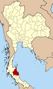
Nakhon Si Thammarat Province
|
|
| Statistics | |
|---|---|
| Capital: | Nakhon Si Thammarat |
| Area: | 9,942.5 km² Ranked 18th |
| Inhabitants: | 1,519,811 (2000) Ranked 5th |
| Pop. density: | 153 inh./km² Ranked 21st |
| ISO 3166-2: | TH-80 |
| Map | |

| |
Nakhon Si Thammarat (often in short Nakhon, Thai นครศรีธรรมราช) is one of the southern provinces (changwat) of Thailand, at the eastern shore of the Gulf of Thailand. Neighboring provinces are (from south clockwise) Songkhla, Phattalung, Trang, Krabi and Surat Thani.
The name of the province derives from its Pali-Sanskrit name Nagara Sri Dhammaraja (City of the Sacred Dharma King), which in Thai pronunciation becames Nakhon Si Thammarat.
| Contents |
Geography
The province is located on the shore of the Gulf of Thailand on the east side of the Malay Peninsula. The terrain is mostly rugged hilly forest area. It contains the highest elevation of southern Thailand, the Khao Luang with 1,835 m, now protected in the Khao Luang national park.
History
The area around Nakhon Si Thammarat was part (according to some scholars even the center) of the Srivijaya kingdom from the 3rd century until king Ramkhamhaeng of Sukhothai occupied it and added it to his kingdom. With the fall of Sukhothai it fell it its successor, the Ayutthaya kingdom. Nakhon became a province in 1932.
Symbols
Seal_Nakhon_Si_Thammarat.png
Provincial seal
The provincial seal shows the Phra Baromathat Chedi of the Wat Phra Mahathat Voramahavihan, one of the most important historical sites in southern Thailand. According to the city chronicle it was already built in 311, but archaeology dates it to the 13th century. The chedi is surrounded by the animals of the Chinese zodiac in the seal. The twelve animals represent the twelve cities or city-states which were tributary to the Nakhon Si Thammarat kingdom: the mouse of Saiburi; the ox of Pattani; the tiger of Kelantan; the rabbit of Pahang (actually a city in Pahang which is said to be submerged by a lake now); a large snake of Kedah; a small snake of Phattalung; a horse of Trang; a goat of Chumphon; a monkey of Bantaysamer (might be Chaiya, or a town in Krabi province); a cock of Sa-ulau (unidentified city, might be Songkhla, Kanchanadit or Pla Tha); a dog of Takua Pa and a pig of Kraburi.
The provincial flower is the Golden Shower Tree (Cassia fistula), and the provincial tree is Millettia atropurpurea.
The provincial slogan is เมืองประวัติศาตร์ พระธาตุทองคำ ชื่นฉ่ำธรรมชาติ, which translates to A historical town, the golden Phra That, plentiful minerals, three-metal nielloware, numerous temples, abundant shellfish.
Administrative divisions
Amphoe_Nakhon_Si_Thammarat.png
Map showing the Amphoe
Nakhon Si Thammarat is subdivided into 21 districts (Amphoe) and 2 minor districts (King Amphoe). The districts are further subdivided into 165 communes (tambon) and 1428 villages (mubaan).
| Amphoe | King Amphoe | |
|---|---|---|
|
|
|
¹ The district Chaloem Phra Kiat was created in 1996 together with Chang Klang, but was elevated from King Amphoe status to Amphoe status before the other ones, hence the jump in numbering.
External links
- Province page from the Tourist Authority of Thailand (http://www.tourismthailand.org/province/province.php?id=3)
- Golden Jubilee Network province guide (http://kanchanapisek.or.th/cgi-bin/kp8/oncc/province.cgi?prov=s4)
fr:Province de Nakhon Si Thammarat ms:Wilayah Nakhon Si Thammarat ja:ナコーンシータンマラート県 nl:Changwat Nakhon Si Thammarat no:Nakhon Si Thammarat (provins) th:จังหวัดนครศรีธรรมราช

