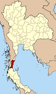
Chumphon Province
|
|
| Statistics | |
|---|---|
| Capital: | Chumphon |
| Area: | 6,009.0 km² Ranked 38th |
| Inhabitants: | 446,206 (2000) Ranked 57th |
| Pop. density: | 74 inh./km² Ranked 59th |
| ISO 3166-2: | TH-86 |
| Map | |

| |
Chumphon (Thai ชุมพร) is one of the southern provinces (changwat) of Thailand, at the shore of the Gulf of Thailand. Neighboring provinces are (from north clockwise) Prachuap Khiri Khan, Surat Thani and Ranong. To the west it also borders Myanmar.
| Contents |
Geography
Chumphon is located on the Isthmus of Kra, the narrow landbridge connecting the Malay Peninsula with the mainland of Thailand.
History
In November 1989 the typhoon Gay hit the province hard - 529 people were killed, 160,000 became homeless, 7,130 km² of farm land was destroyed. Gay is the only tropical storm on record which reached Thailand with typhoon wind strength.
Symbols
| Missing image Seal_Chumphon.png Provincial seal | The provincial seal shows an angel, which gives blessing to the people. It is placed between two Cluster Fig trees (Ficus racemosa), which is also the provincial tree. The provincial flower is the Indian shot (Canna indica), and the finger banana is another provincial symbol. |
Administrative divisions
Amphoe_Chumphon.png
map of Amphoe
Chumphon is subdivided into 8 districts (Amphoe). These are further subdivided into 70 communes (tambon) and 674 villages (mubaan).
|
|
External links
- Province page from the Tourist Authority of Thailand (http://www.tourismthailand.org/province/province.php?id=1)
- Golden Jubilee Network province guide (http://kanchanapisek.or.th/cgi-bin/kp8/oncc/province.cgi?prov=s2)
- Official homepage (http://www.chumphon.go.th) (Thai only)
fr:Province de Chumpon ms:Wilayah Chumphon nl:Changwat Chumphon ja:チュムポーン県 no:Chumphon (provins) th:จังหวัดชุมพร

