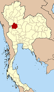
Kamphaeng Phet Province
|
|
| Statistics | |
|---|---|
| Capital: | Kamphaeng Phet |
| Area: | 8,607.5 km² Ranked 22nd |
| Inhabitants: | 674,027 (2000) Ranked 35th |
| Pop. density: | 78 inh./km² Ranked 53rd |
| ISO 3166-2: | TH-61 |
| Map | |

| |
Kamphaeng Phet (Thai กำแพงเพชร) is one of the provinces (changwat) of Thailand, located in the north of the country. Neighboring provinces are (from north clockwise) Sukhothai, Phitsanulok, Phichit, Nakhon Sawan and Tak.
| Contents |
Geography
Banana_Festival_Kampheang_Phet.jpg
One of the most well-known products of the province is banana. Banana festivals take place in the province every year, to thank the gods for the harvest.
History
Kamphaeng Phet already was a royal city in the Sukhothai kingdom in the 14th century, then known under its old name Chakangrao. It formed an important part of the defence system of the kingdom, as well as later of the Ayutthaya kingdom.
Symbols
| Missing image Seal_Kamphaeng_Phet.png Provincial seal | The provincial seal shows the city walls, as the city name means diamond wall. Provincial tree is Acasia catechu, provincial flower the Bullet Wood (Mimusops elengi). |
Administrative divisions
Amphoe_Kamphaeng_Phet.png
Map of Amphoe
The province is subdivided in 9 districts (Amphoe) and two minor districts (King Amphoe). These are further subdivided into 78 communes (tambon) and 823 villages (mubaan).
| Amphoe | King Amphoe | |
|---|---|---|
|
|
|
External links
- Province page from the Tourist Authority of Thailand (http://www.tourismthailand.org/province/province.php?id=17)
- Golden Jubilee Network province guide (http://kanchanapisek.or.th/cgi-bin/kp8/oncc/province.cgi?prov=n1)
fi:Kamphaeng Phet fr:Province de Kamphaeng Phet ja:カムペーンペット県 ms:Wilayah Kamphaeng Phet nl:Changwat Kamphaeng Phet no:Kamphaeng Phet (provins) th:จังหวัดกำแพงเพชร

