Satun Province
|
|
| Statistics | |
|---|---|
| Capital: | Satun |
| Area: | 2,479.0 km² Ranked 63rd |
| Inhabitants: | 247,875 (2000) Ranked 69th |
| Pop. density: | 100 inh./km² Ranked 45th |
| ISO 3166-2: | TH-91 |
| Map | |

| |
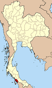
Satun (Thai สตูล) is one of the southern provinces (changwat) of Thailand. Neighboring provinces are (from north clockwise) Trang, Phattalung and Songkhla. To the south it borders Malaysia. The name Satun is a Thai corruption of the Malay Setul, meaning mangosteen tree.
| Contents |
Geography
The province is located on the Malay Peninsula, on the shore of the Andaman Sea. The Ko Tarutao (Malay Pulau Tertua) and Ko Phetra (Pulau Petra) marine national parks are part of the province. Close to the border with Malaysia is the Thale Ban national park, a big freshwater swamp area.
History
Until 1813 Satun was a district of the Malayan state of Kedah, then known as Mukim Setul. With the Anglo-Siamese contract of 1909 Kedah was split between the English and Thailand, and due to a large Siamese population Satun went to Thailand. It was at first administrated as part of the monthon Phuket, which in 1925 was included into monthon Nakhon Si Thammarat. In 1933 the monthon were dissolved and the province became a first-level subdivision of Thailand.
Demographics
Satun is one of the four provinces of Thailand which have a muslim majority: 67.8% are muslim, only 31.9% are buddhists. Most of the Muslims have some ethnic-Malay ancestry (although 9.9% of the population claims to be ethnically Malay).
Because region of Satun belonged to Kedah Sultanate which had a strong relationship with Ayutthaya as well as with Siam of the Chakri dynasty traditionally, its population of Malay muslims commonly marries with Thai Buddhists without serious religious hesitation. This custom created an ethnic group known as Samsam, meaning mixed person.
Malay Muslims in Satun are substantially assimilated and rarely claim separatism from Thailand compared to the Malay muslims in Pattani, Narathiwat and Yala.
Symbols
| Missing image Seal_Satun.png Provincial seal | The provincial seal shows Pra Samut Thewaa sitting on a stone in the sea, with the sunset behind. Pra Samut Thewaa is the god who guards the sea, the stone his divine vehicle. The sunset symbolizes the Andaman Sea, which lies to the west of the province.
The provincial tree is the Thai Rosewood or P ha-yungklaep (Dalbergia bariensis), and the provincial flower is the Snowy Orchid Tree (Bauhinia acuminata). The provincial slogan is Peaceful, Clean and Pure Nature. |
Administrative divisions
Amphoe_Satun.png
Map of Ampoe
Satun is subdivided into 6 districts (Amphoe) and one minor district (King Amphoe). These are further subdivided into 36 communes (tambon) and 257 villages (mubaan).
| Amphoe | King Amphoe | |
|---|---|---|
|
|
|
External links
- Province page from the Tourist Authority of Thailand (http://www.tourismthailand.org/province/province.php?id=10)
- Golden Jubilee Network province guide (http://kanchanapisek.or.th/cgi-bin/kp8/oncc/province.cgi?prov=s13)
ms:Wilayah Satun nl:Changwat Satun no:Satun (provins) ja:サトゥーン県 th:จังหวัดสตูล

