Chainat Province
|
|
| Statistics | |
|---|---|
| Capital: | Chainat |
| Area: | 2,469.7 km² Ranked 64th |
| Inhabitants: | 359,829 (2000) Ranked 62nd |
| Pop. density: | 146 inh./km² Ranked 26th |
| ISO 3166-2: | TH-18 |
| Map | |

| |
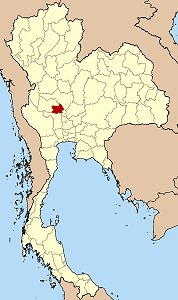
Chainat (Thai ชัยนาท) is one of the central provinces (changwat) of Thailand. Neighboring provinces are (from north clockwise) Nakhon Sawan, Sing Buri, Suphanburi and Uthai Thani.
| Contents |
Geography
Chainat is located in the flat river plain of the Chao Phraya river valley. In the south of the province the Chainat dam blocks the Chao Phraya river, both for flood control as well as to split off water to the irrigation of the rice paddies of the lower river valley. The dam, part of the Greater Chao Phraya Project, was finished in 1957 and was the first dam of Thailand.
History
Originally the city was located at Sankhaburi. In the reign of King Mongkut (Rama IV) the main settlement of the province was moved to todays location. During the wars with the Burmese it was an important military base to confront with the Burmese arms. As all these confrontations were successful the city gained the name Chainat, which means place of victory.
Symbols
| Missing image Seal_Chainat.png Seal of the province | The provincial seal shows the Buddhist wheel, the Dhammajakra. In the background is a mountain and a river. The wheel symbolizes the faith of the residents. Provincial tree is the Bael Fruit Tree (Aegle marmelos), provincial flower the Rainbow Shower Tree (Cassia javanica). |
Administrative divisions
Amphoe_Chainat.png
Map of Amphoe
Chainat is subdivided into 6 districts (Amphoe) and 2 minor districts (King Amphoe). The districts are further subdivided into 53 communes (tambon) and 474 villages.
| Amphoe | King Amphoe | |
|---|---|---|
|
|
|
External links
- Province page from the Tourist Authority of Thailand (http://www.tourismthailand.org/province/province.php?id=57)
- Golden Jubilee Network province guide (http://kanchanapisek.or.th/cgi-bin/kp8/oncc/province.cgi?prov=c6)

