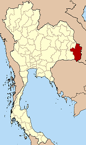
Ubon Ratchathani Province
|
|
| Statistics | |
|---|---|
| Capital: | Ubon Ratchathani |
| Area: | 15,744.8 km² Ranked 5th |
| Inhabitants: | 1,691,441 (2000) Ranked 4th |
| Pop. density: | 107 inh./km² Ranked 44th |
| ISO 3166-2: | TH-34 |
| Map | |

| |
Ubon Ratchathani (often in short Ubon, Thai อุบลราชธานี) is one of the north-eastern provinces (changwat) of Thailand. Neighboring provinces are (from west clockwise) Sisaket, Yasothon and Amnat Charoen. To the north and east it borders Laos, to the south Cambodia.
| Contents |
Geography
At Khong Chiam the Mun river, the biggest river of the Khorat Plateau, joins the Mekong, which forms the north-eastern boundary of Thailand with Laos. The area where the borders of the three countries Thailand, Laos and Cambodia meet is promoted as the Emerald Triangle, in contrast to the Golden Triangle in the north of Thailand. The Emerald refers to the large intact monsoon forests there.
History
The area was part of the Khmer Empire, until King Ramathibodi of Ayutthaya defeated it and made it part of his kingdom. After the fall of Ayutthaya in 1767 several new tribes settled there, including the Kha and Suai. Twenty years later King Rama I offered a noble title to the local leader who could unite the many small settlements into one town. This was accomplished in 1786 with the founding of Ubon Ratchathani by Thao Khamphong, and in 1792 it became a province. Ubon Ratchathani became the administrative center of the monthon Isan, of which monthon Ubon was split off. In 1925 it became part of monthon Nakhon Ratchasima, with the abolishment of the monthon in 1933 the province became a first level subdivision of the country.
Until 1972 the Ubon Ratchathani province was the largest province of Thailand areawise. In 1972 Yasothon was split off, in 1993 Amnat Charoen, after which it now holds the 5th rank.
Symbols
| Missing image Seal_Ubon_Ratchathani.png Provincial seal | The provincial seal shows a Lotus flower in a pond. This refers to the meaning of the name of the province, which translates to Royal city of the lotus flower. Therefore the provincial flower also is the Lotus (Nymphaea lotus). The provincial tree is the Yang-khao (Dipterocarpus alatus). |
Administrative divisions
Amphoe_Ubon_Ratchathani.png
Map of Amphoe
The province is subdivided into 20 districts (Amphoe) and 5 minor districts (King Amphoe). The districts are further subdivided into 219 communes (tambon) and 2469 villages. The numbers missing in the table are the Amphoe which formed Amnat Charoen Province in 1993.
| Amphoe | King Amphoe | |
|---|---|---|
|
|
|
Miscellaneous
Ubon Ratchathani province is the main site of Ubon Ratchathani University.
External links
- Province page from the Tourist Authority of Thailand (http://www.tourismthailand.org/province/province.php?id=48)
- Golden Jubilee Network province guide (http://kanchanapisek.or.th/cgi-bin/kp8/oncc/province.cgi?prov=e19)
fr:Province de Ubon Ratchathani ja:ウボンラーチャターニー県 nl:Changwat Ubon Ratchathani no:Ubon Ratchathani (provins) th:จังหวัดอุบลราชธานี

