Lambton County, Ontario
|
|
Ontlam.PNG
Lambton County
Lambton County, Ontario is a census division of the Canadian province of Ontario. The county is located in Southwestern Ontario. It is bordered on the north by Lake Huron, which flows into the St. Clair River, the county's western border and part of the Canada-U.S.A. border. To the south is Lake Saint Clair and Chatham-Kent, another county in Ontario. Lambton County's eastern border follows the Ausauble River north until it reaches Lake Huron at the beach community of Grand Bend.
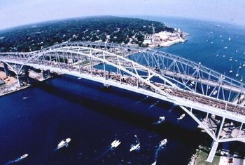
The the county seat and largest city in Lambton County is Sarnia (pop. 70,876 in the 2001 census), at the mouth of the St. Clair River. The two Blue Water Bridges cross the river at Sarnia, connecting it to Port Huron, Michigan. The bridges are one of the busiest border crossings between these two countries. The river is also traversed by a passenger ferry further south, and a rail tunnel runs underneath it (also at Sarnia).
Today the petrochemical industry is arguably the most important sector of Lambton County's economy. Established during World War II, Sarnia and the area along the St. Clair River is home to a major processing centre for oil from Alberta. The industry is so pervasive that it has earned this region along the river the nickname "Chemical Valley". Often the moniker is used after a chemical spill into the river or a day of extreme air pollution.
Oil_well3419.jpg
Tourism is another important industry in Lambton County, especially along the lake and river. The community of Grand Bend, and the Pinery provincial park are especially popular tourist destinations, attracting thousands of people each week throughout the summer to their long, uninterrupted beaches. The part of Lambton County along Lake Huron known as Lambton Shores depends almost entirely upon the seasonal industries of tourism and agriculture for its well-being. There are also popular conservation areas along the Saint Clair River, and a conservation area called Rock Glen Falls near Arkona along the Ausauble River known for its well preserved fossils.
Though no longer as important to the county's economic well-being, agriculture is still what sustains many small towns in the interior of Lambton County. The three most popular crops are corn, wheat, and soybeans, although canola and sugar beets (among other things) are sometimes planted. Many farmers raise cattle in addition to growing crops.

Municipalities
- City of Sarnia
- Municipality (city) of Lambton Shores
- Town of Petrolia
- Town of Plympton-Wyoming
- Township of Brooke-Alvinston
- Township of Dawn-Euphemia
- Township of Enniskillen
- Township of St. Clair
- Township of Warwick
- Village of Oil Springs
- Village of Point Edward
The Chippewas of Kettle and Stony Point First Nation occupies the Kettle Point area, separate from the surrounding municipality of Lambton Shores but included in the county.
Communities
- Alvinston
- Arkona
- Brigden
- Corunna
- Forest
- Grand Bend
- Petrolia
- Point Edward
- Port Franks
- Sarnia
- Sombra
- Thedford
- Walpole Island
- Watford
- Wyoming
External Link
- Lambton County - The Corporation of the County of Lambton (http://www.lambtononline.ca/)
Related Link:
| Census Divisions of Ontario | 
| ||
|---|---|---|---|
| Counties of Ontario: Bruce | Dufferin | Elgin | Essex | Frontenac | Grey | Haliburton | Hastings | Huron | Lambton | Lanark | Leeds and Grenville | Lennox and Addington | Middlesex | Northumberland | Perth | Peterborough | Prescott and Russell | Renfrew | Simcoe | Stormont, Dundas and Glengarry | Wellington | |||
| Regional Municipalities of Ontario: Durham | Halton | Muskoka | Niagara | Oxford | Peel | Waterloo | York | |||
| Single Tier Municipalities of Ontario: Brant | Brantford | Chatham-Kent | Greater Sudbury | Haldimand | Hamilton | Kawartha Lakes | Norfolk | Ottawa | Prince Edward | Toronto | |||
| Separated municipalities - Historic counties of Ontario | |||
| Districts of Ontario: Algoma | Cochrane | Kenora | Manitoulin | Nipissing | Parry Sound | Rainy River | Sudbury | Thunder Bay | Timiskaming | |||
