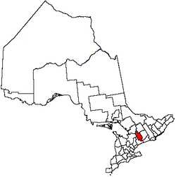
Kawartha Lakes, Ontario
|
|

The City of Kawartha Lakes is a city in east-central Ontario, Canada, and makes up the former County of Victoria. The main centres are Omemee, Lindsay, Oakwood, Janetville, Bethany, Fenelon Falls, Woodville, and Bobcaygeon.
In a very close vote (51% for/ 49% against) the citizens of Kawartha Lakes voted to de-amalgamate in November, 2003 into the former towns, villages, and townships of the former County of Victoria, but it might be years before de-amalgamation is complete, if it happens at all. The newly elected city government has declared that there will NOT be de-amalgamation.
The city is named for the Kawartha lakes; "Kawartha" means "shining waters" in the Ojibwe language.
Kawartha Lakes is the largest city in area in Southern Ontario.
| Contents |
Demographics
According to the 2001 Statistics Canada Census:
- Population: 69,179
- % Change (1996-2001): 1.8
- Dwellings: 34,637
- Area (sq. km.): 3,059.22
- Density (persons per sq. km.): 22.6
People
The 2001 census conglommeration tells us that Kawartha Lakes has 69,179 and grows at an average 0.24% a year.
Racial Profile
- 97.9% White
- 1.1% Aboriginal
- 0.2% Black
Religious Groups
- 59.7% Protestant
- 18.0% Roman Catholic
Communities
- Ancona Point
- Argyle
- Avery Point
- Baker Trail
- Ballyduff
- Bethany
- Bethel
- Bexley
- Birch Point
- Bobcaygeon
- Bolsover
- Brunswick
- Burnt River
- Bury's Green
- Cambray
- Cameron
- Campbells Beach
- Camp Kagawong
- Coboconk
- Corsons
- Cowan's Bay
- Crawfords Beach
- Cresswell
- Cunningham's Corners
- Dalrymple
- Daytonia Beach
- Dongola
- Downeyville
- Dunsford
- East Emily
- Eldon
- Fairburn Corner
- Feir Mill
- Fenelon Falls
- Fingerboard
- Fleetwood
- Fleetwood Homes
- Fleetwood Station
- Fowler's Corners
- Fox's Corners
- Frank Hill
- Franklin
- Gilsons Point
- Glamorgan
- Glandine
- Glenarm
- Glenway Village
- Grasshill
- Greenhurst-Thurstona
- Hartley
- Head Lake
- Hickory Beach
- Hillhead Corners
- Hukish
- Isaacs Glen
- Islay
- Janetville
- Joyvista Estates
- Kenedon Park
- Krenrei
- Keystone Beach
- Kings Wharf
- Kinmount
- Kirkfield
- Lake Dalrymple
- Lakeview Estates
- Lancaster Bay
- Lifford
- Linden Valley
- Lindsay
- Little Britain
- Long Beach
- Long Point
- Lorneville
- Lotus
- MacKenzie Point
- Mallards Bay
- Manilla
- Manvers
- Mariposa
- McCrackins Beach
- McGuire Beach
- Mount Hereb
- Newmans Beach
- Norland
- Oakdene Point
- Oakwood
- O'Donnell Landing
- Omemee
- Orange Corners
- Pickerel Point
- Pleasant Point
- Pontypool
- Powles Corners
- Ragged Rapids
- Reaboro
- Red Cap Beach
- Rohallion
- Sadowa
- Sandy Point
- Sebright
- Silver Lake
- Snug Harbour
- Sonya
- Soutview Estates
- Starr's Beach
- Sturgeon Point
- Sullivan's Bay
- Sylvan Glen Beach
- Taylor Corners
- Tracey's Hill
- Union Creek
- Uphill
- Valentia
- Verulam Park
- Victoria Road
- Washburn Island
- Watsons
- Woodville
- Yelverton
- Zion
Highways
Highways that run through Kawartha Lakes are as follows:
King's Highways: Trans-Canada #7, #7A, #35, #115
Protected Areas
- Dalton Digby Wildlands Provincial Park
- Balsam Lake Provincial Park
- Indian Point Provincial Park
- Emily Provincial Park
- Pigeon River Headwaters Conservation Area
- Fleetwood Creek Conservation Area
- Windy Ridge Conservation Area
- Ken Reid Conservation Area
Attractions
- Devil's Elbow Ski Area (Bethany)
- Ganaraska Hiking Trail
- Lindsay Airport (Lindsay)
- Victoria County Museum (Lindsay)
- Monck Historical Colonization Road
- Victoria Recreation Corridor
- Victoria Historical Colonization Road
- Fenelon Falls Museum (Fenelon Falls)
- Bobcaygeon Historic Colonization Road
- Highland Cinema and Museum
- Trent-Severn Waterway
- Kirkfield Lift Lock
- Rosedale Lock 35
- Fenelon Falls Lock 34 (Fenelon Falls)
- Bobcaygeon Lock 32 (Bobcaygeon)
Census Division (counties, etc.) Rankings
National rank in terms of population: 86
Provincial rank in terms of population: 35
Surrounding Counties
- Muskoka District Municipality, Ontario
- Haliburton County, Ontario
- Peterborough County, Ontario
- Durham Regional Municipality, Ontario
- Simcoe County, Ontario
| North: Gravenhurst, Bracebridge, Minden Hills | ||
| West: Ramara, Brock, | Kawartha Lakes | East: Galway-Cavendish and Harvey, Smith-Ennismore-Lakefield |
| South: Scugog, Clarington, Cavan-Millbrook-North Monaghan |
| Census Divisions of Ontario | 
| ||
|---|---|---|---|
| Counties of Ontario: Bruce | Dufferin | Elgin | Essex | Frontenac | Grey | Haliburton | Hastings | Huron | Lambton | Lanark | Leeds and Grenville | Lennox and Addington | Middlesex | Northumberland | Perth | Peterborough | Prescott and Russell | Renfrew | Simcoe | Stormont, Dundas and Glengarry | Wellington | |||
| Regional Municipalities of Ontario: Durham | Halton | Muskoka | Niagara | Oxford | Peel | Waterloo | York | |||
| Single Tier Municipalities of Ontario: Brant | Brantford | Chatham-Kent | Greater Sudbury | Haldimand | Hamilton | Kawartha Lakes | Norfolk | Ottawa | Prince Edward | Toronto | |||
| Separated municipalities - Historic counties of Ontario | |||
| Districts of Ontario: Algoma | Cochrane | Kenora | Manitoulin | Nipissing | Parry Sound | Rainy River | Sudbury | Thunder Bay | Timiskaming | |||
