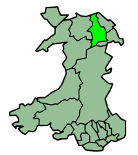
Denbighshire
|
|
| Denbighshire principal area | |
|---|---|

| |
| Geography | |
| Area - Total - % Water | Ranked 8th 844 km² ? % |
| Admin HQ | Ruthin |
| ISO 3166-2 | GB-DEN |
| ONS code | 00NG |
| Demographics | |
| Population - Total (April 29, 2001) - Density | Ranked 16th 93,065 110 / km² |
| Ethnicity | 99.3% White. |
| Welsh language - Any skills | Ranked 6th 36.0% |
| Politics | |
| Denbighshire County Council http://www.denbighshire.gov.uk/ | |
| Control | Multi-party |
| MPs | David Jones Martyn Jones Chris Ruane |
| AMs | Karen Sinclair Ann Jones Alun Pugh (Constituency) North Wales (Regional) |
| MEPs | Wales |
Template:Infobox Wales traditional county
Missing image
Denbighshirearms.PNG
Arms of Denbighshire
Denbighshire (Welsh: Sir Ddinbych) is a principal area and traditional county in North Wales.
| Contents |
Principal area
The current principal area of Denbighshire was created in 1996, with substantially different borders to the traditional county of the same name. Places in the principal area include:
Geography
The area is mostly hilly moorland, with the Clwydian range in the east, the Hiraethog Moors in the west and the Berwyn range adjacent to the southern boundary. The broad, fertile Vale of Clwyd runs south to north in the centre, and there is a narrow coastal plain in the north. Average temperatures are 2°C in January and 19°C in July.
Population
Denbighshire's total population at the 2001 census was 93,065, with the largest towns on the coast at Rhyl (pop. c.25,000) and Prestatyn (pop. c.15,000). The inland towns are much smaller, Denbigh having a population of 8,500, Ruthin 5,000, and Llangollen 3,300. 18% of the population speaks Welsh, mainly in the upland area and the Vale of Clwyd.
Economy
There are no heavy industrial sites in the county although most of the towns have small industrial estates for light industry, the economy of the area being based on agriculture and tourism. A large proportion of the working population is employed in service industries. The uplands support the rearing of sheep and beef cattle, while in the Vale of Clwyd dairy farming and the growing of wheat and barley predominates.
On November 19, 2004, Denbighshire was granted Fairtrade County status.
Traditional county
The borders of the traditional county are substantially different to that of the principal area.
Geography
Denbighshire is a maritime county, bounded to the north by the Irish Sea, to the east by Flintshire, Cheshire and Shropshire, to the south by Montgomeryshire and Merionethshire, and to the west by Caernarfonshire. In the south and west of the county the mountains of the Clwydian Range rise from 1000 to 2500ft high. The east of the county is hilly. There is some level ground along the coastal strip. The highest points are Moel Sych and Cader Berwyn at 2,713 feet. Pistyll-y-Rhaeader is a spectacular 240 feet waterfall. The chief rivers are the Clwyd and the Dee. The River Conwy runs north along the western boundary.
The main towns are Abergele, Denbigh, Colwyn Bay, Llangollen, Llanrwst, Ruthin and Wrexham. The most important industries are agriculture and tourism.
Places of special interest: Bodnant Gardens, Tal-y-Cafn (Template:Gbmapping); Chirk Castle (Template:Gbmapping); Denbigh Castle (Template:Gbmapping); Eliseg's Pillar (Template:Gbmapping); Plas Newydd, Llangollen (Template:Gbmapping); Valle Crucis Abbey (Template:Gbmapping).
| United Kingdom | Wales | Principal areas of Wales | 
|
|
Anglesey | Blaenau Gwent | Bridgend | Caerphilly | Cardiff | Carmarthenshire | Ceredigion | Conwy | Denbighshire | Flintshire | Gwynedd | Merthyr Tydfil | Monmouthshire | Neath Port Talbot | Newport | Pembrokeshire | Powys | Rhondda Cynon Taff | Swansea | Torfaen | Vale of Glamorgan | Wrexham |
Template:Wales traditional countiescy:Sir Ddinbych fr:Sir Ddinbych no:Denbighshire
