Wrexham (county borough)
|
|
| Wrexham county borough | |
|---|---|

| |
| Geography | |
| Area - Total - % Water | Ranked 10th 498 km² ? % |
| Admin HQ | Wrexham |
| ISO 3166-2 | GB-WRX |
| ONS code | 00NL |
| Demographics | |
| Population - Total (April 29, 2001) - Density | Ranked 10th 128,645 258 / km² |
| Ethnicity | 97.2% White 2.4% S.Asian. |
| Welsh language - Any skills | Ranked 10th 22.9% |
| Politics | |
 Wrexham County Borough Council http://www.wrexham.gov.uk/ | |
| Control | All-party |
| MPs | Martyn Jones Ian Lucas |
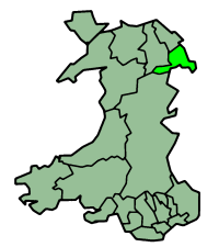
Wrexham is a county borough in northern Wales. It covers parts of the traditional county of Denbighshire around Wrexham itself, and the detached parts of Flintshire - English Maelor and Marford.
It is named after Wrexham, its main town, has a population of 130,000 inhabitants. Other places in the borough include Gwersylt, Ruabon, and Chirk.
The county borough was formed on April 1, 1996. Most of the area was previously part of the Welsh district of Wrexham Maelor - with a few areas coming from Glyndwr.
| United Kingdom | Wales | Principal areas of Wales | 
|
|
Anglesey | Blaenau Gwent | Bridgend | Caerphilly | Cardiff | Carmarthenshire | Ceredigion | Conwy | Denbighshire | Flintshire | Gwynedd | Merthyr Tydfil | Monmouthshire | Neath Port Talbot | Newport | Pembrokeshire | Powys | Rhondda Cynon Taff | Swansea | Torfaen | Vale of Glamorgan | Wrexham |
