Apache County, Arizona
|
|
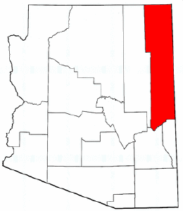
Apache County is located in the northeast corner of the U.S. state of Arizona. As of 2000 its population was 69,423. The county seat is St. Johns.
Geography
Apache County contains parts of the Navajo Indian Reservation, the Fort Apache Indian Reservation, and Petrified Forest National Park. Canyon De Chelly National Monument is entirely within the county.
According to the U.S. Census Bureau, the county has a total area of 29,056 km² (11,218 mi²). 29,020 km² (11,205 mi²) of it is land and 35 km² (14 mi²) of it is water. The total area is 0.12% water.
Demographics
As of the census2 of 2000, there are 69,423 people, 19,971 households, and 15,257 families residing in the county. The population density is 2/km² (6/mi²). There are 31,621 housing units at an average density of 1/km² (3/mi²). The racial makeup of the county is 76.88% Native American, 19.50% White, 0.25% Black or African American, 0.13% Asian, 0.06% Pacific Islander, 1.75% from other races, and 1.43% from two or more races. 4.49% of the population are Hispanic or Latino of any race.
There are 19,971 households out of which 43.80% have children under the age of 18 living with them, 49.30% are married couples living together, 21.40% have a female householder with no husband present, and 23.60% are non-families. 21.20% of all households are made up of individuals and 6.90% have someone living alone who is 65 years of age or older. The average household size is 3.41 and the average family size is 4.04.
In the county the population is spread out with 38.50% under the age of 18, 9.40% from 18 to 24, 25.10% from 25 to 44, 18.70% from 45 to 64, and 8.30% who are 65 years of age or older. The median age is 27 years. For every 100 females there are 98.20 males. For every 100 females age 18 and over, there are 94.50 males.
The median income for a household in the county is $23,344, and the median income for a family is $26,315. Males have a median income of $30,182 versus $22,312 for females. The per capita income for the county is $8,986. 37.80% of the population and 33.50% of families are below the poverty line. Out of the total population, 42.80% of those under the age of 18 and 36.50% of those 65 and older are living below the poverty line.
Apache County is one of only 38 county-level census divisions of the United States where the most spoken language is not English and one of only 3 where it is neither English nor Spanish. 58.32% of the population speak Navajo at home, followed by English at 38.34% and Spanish at 2.72%.
Cities and towns
- Burnside
- Chinle
- Dennehotso
- Eagar
- Fort Defiance
- Ganado
- Houck
- Lukachukai
- Many Farms
- McNary
- Nazlini
- Red Mesa
- Rock Point
- Rough Rock
- Round Rock
- Sawmill
- Springerville
- St. Johns
- St. Michaels
- Steamboat
- Teec Nos Pos
- Tsaile
- Window Rock
| Regions of Arizona | 
|
|---|---|
| North Central Arizona | Northern Arizona | Phoenix metropolitan area | Southern Arizona | |
| Largest cities | |
| Apache Junction | Avondale | Bullhead City | Casas Adobes | Catalina Foothills | Chandler | Flagstaff | Gilbert | Glendale | Lake Havasu City | Mesa | Nogales | Payson | Peoria | Phoenix | Prescott | Scottsdale | Sierra Vista | Sun City | Surprise | Tempe | Tombstone | Tucson | Yuma | |
| Counties | |
| Apache | Cochise | Coconino | Gila | Graham | Greenlee | La Paz | Maricopa | Mohave | Navajo | Pima | Pinal | Santa Cruz | Yavapai | Yuma |

