Yokohama, Kanagawa
|
|
- For the town of Yokohama in Aomori Prefecture, see Yokohama, Aomori.
| Yokohama (横浜) | ||
| Country | Japan | |
| Region | Kanto | |
| Prefecture | Kanagawa | |
| Area | 437.35km² | |
| Population | 3,573,588 as of June, 2005 | |
| Density | 8171 | |
| Mayor | Hiroshi Nakada | |
| City symbols | Tree | Camellia,Chinquapin,Sangoju Sasanqua,Ginkgo,Zelkova |
| Flower | Rose | |
| Missing image CitySymbol-Yokohama.png | ||
| Yokohama City Hall | ||
| Address | 〒231-0017 | |
| Yokohama-shi, Naka-ku, Minato-cho 1-1 | ||
| Phone | 045-671-2121 | |
| Latitude & Longitude | 35°26' N 139°38' E | |
| Missing image Yokohama-CityMap.png | ||
| Notes | ||
Yokohama.jpg
1853Yokohama_01.jpg

Yokohama (Japanese: 横浜市; -shi) is the capital city of Kanagawa Prefecture in Japan. It is Japan's largest incorporated city and largest seaport, and a commercial hub of the Greater Tokyo Area.
| Contents |
History
Yokohama was a small fishing village up to the end of the Edo period, a time when Japan conducted very little trade with foreign countries. In 1854, Commodore Matthew Perry arrived just south of Yokohama with a fleet of American warships, and forced Japan to open several ports for commerce. Yokohama was designated as a foreign port instead of Kanagawa, which the Tokugawa shogunate feared was too close to the Tokaido, a strategic highway connecting Edo to Nagoya, Kyoto, and Osaka.
The Port of Yokohama was opened in 1859 and quickly became the base of most foreign trade in Japan. Foreigners occupied a district of the city called 'Kannai' ("inside the barrier"), which was surrounded by a moat.
After the Meiji Restoration of 1868, the port was developed for trading silk. Japan's first railway was constructed in 1872 to connect Yokohama to Tokyo, allowing zaibatsu firms to use the port for importing raw materials bound for factories in the growing Keihin Industrial Area. The growth of Japanese industry brought affluence to Yokohama, and many wealthy trading families constructed sprawling residences there. Until more commerce was carried out directly in Tokyo, Yokohama was known as the most international city in Japan.
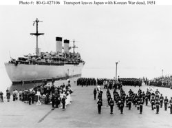
Much of Yokohama was destroyed in the Great Kanto Earthquake, and the city was firebombed by U.S. aircraft during World War II. During the American occupation, Yokohama was a major transshipment base for American supplies and personnel, especially during the Korean War. After the occupation, most local U.S. naval activity moved from Yokohama to an American base in neighboring Yokosuka.
The city was officially incorporated on April 1, 1889, and designated by government ordinance on September 1, 1956.
Geography
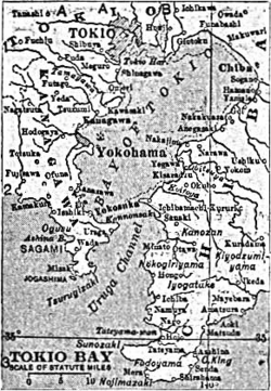
Yokohama is located on a peninsula facing the western side of Tokyo Bay, 30 kilometers (18 miles) from Tokyo, to which it is connected by a half-dozen railway lines as well as expressways and surface streets. Although the city is largely a bedroom community for people commuting to Tokyo, it also has a strong local economic base, especially in the shipping, biotechnology, and semiconductor industries. Nissan will move its headquarters to Yokohama from Chuo-ku, Tokyo, by 2010.
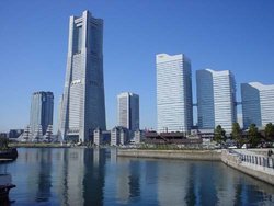
Sightseeing spots in Yokohama include the port area (Yamashita Park, Minato Mirai 21, and Chinatown), the Yamate area (foreigners' cemetery and harbour view park), and Sankeien, a garden in the Japanese style. The Isezakicho and Noge areas offer many colourful shops and bars and, with their restaurants and stores catering to residents from China, Thailand, South Korea, and other countries, have an increasingly international flavour. The ramen museum and the curry museum are other interesting spots recently opened in Yokohama.
Yokohama is the home of the Yokohama BayStars, a Central League baseball team, and the Yokohama F Marinos, a J. League soccer team. The final game of the 2002 World Cup was played in Yokohama International Sports Stadium.
Wards
Yokohama has 18 wards (ku):
- Aoba-ku (青葉区)
- Asahi-ku (旭区)
- Hodogaya-ku (保土ヶ谷区)
- Isogo-ku (磯子区)
- Izumi-ku (泉区)
- Kanagawa-ku (神奈川区)
- Kanazawa-ku (金沢区)
- Kohoku-ku (港北区)
- Konan-ku (港南区)
- Midori-ku (緑区)
- Minami-ku (南区)
- Naka-ku (中区)
- Nishi-ku (西区)
- Sakae-ku (栄区)
- Seya-ku (瀬谷区)
- Totsuka-ku (戸塚区)
- Tsurumi-ku (鶴見区)
- Tsuzuki-ku (都筑区)
Demographics
As of October 1, 2004, the city has an estimated population of 3,555,473 and the density of 8,174 persons per km². The total area is 434.98 km².
Yokohama in fiction
Yokohama during the 1860s was the setting of James Clavell's final novel, Gai-Jin.
In Shadow Hearts 2, one of the towns/cities you visit is circa 1915 Yokohama.
Yu Miri's novel Gold Rush (1998; English translation 2002), is set in and around the Kogane-cho area of central Yokohama.
The manga series Yokohama Kaidashi Kikō written and drawn by Hitoshi Ashinano (芦奈野ひとし) features several scenes set in a post-ecodisaster Yokohama.
See also
External links
- Official website (http://www.city.yokohama.jp/en/) in English
- Naka Ward Office (http://www.city.yokohama.jp/me/naka/e/) in English
- Wikitravel: Yokohama (http://wikitravel.org/en/article/Yokohama)
| edit (http://en.wikipedia.org/w/wiki.phtml?title=Template:Japan&action=edit) | Prefectures of Japan | Missing image Japan_flag_large.png Flag of Japan |
|---|---|---|
| Aichi | Akita | Aomori | Chiba | Ehime | Fukui | Fukuoka | Fukushima | Gifu | Gunma | Hiroshima | Hokkaido | Hyogo | Ibaraki | Ishikawa | Iwate | Kagawa | Kagoshima | Kanagawa | Kochi | Kumamoto | Kyoto | Mie | Miyagi | Miyazaki | Nagano | Nagasaki | Nara | Niigata | Oita | Okayama | Okinawa | Osaka | Saga | Saitama | Shiga | Shimane | Shizuoka | Tochigi | Tokushima | Tokyo | Tottori | Toyama | Wakayama | Yamagata | Yamaguchi | Yamanashi | ||
| Regions of Japan | ||
| Hokkaido | Tohoku | Kanto | Chubu (Hokuriku - Koshinetsu - Tokai) | Kansai | Chugoku | Shikoku | Kyushu | ||
| Major Cities | ||
| 23 wards of Tokyo | Chiba | Fukuoka | Hiroshima | Kawasaki | Kitakyushu | Kobe | Kyoto | Nagoya | Osaka | Saitama | Sapporo | Sendai | Yokohama | ||
ar:يوكوهاما da:Yokohama de:Yokohama es:Yokohama eo:Jokohamo fr:Yokohama it:Yokohama lt:Jokohama nl:Yokohama ja:横浜市 no:Yokohama pl:Jokohama pt:Yokohama simple:Yokohama fi:Jokohama zh:横滨


