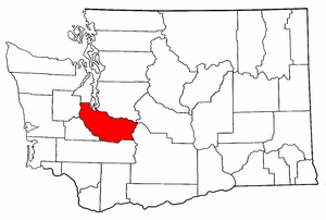
Pierce County, Washington
|
|
Pierce County is the second most populous county in the state of Washington. It was named for U.S. President Franklin Pierce. As of 2004, the population was 744,000. The county seat is Tacoma, on Commencement Bay.
Pierce County is notable for being home to the Mount Rainier volcano, the tallest mountain in the Cascade Range. Its most recent recorded eruption was between 1820 and 1854. There is no imminent risk of eruption, but geologists expect that the volcano will erupt again. If this should happen, parts of Pierce County would be at risk from lahars, lava, or pyroclastic flows. The Mount Rainier Volcano Lahar Warning System was established in 1998 to assist in the evacuation of the Puyallup River valley in case of eruption.
| Contents |
Geography
According to the U.S. Census Bureau, the county has a total area of 4,679 km² (1,806 mi²). 4,348 km² (1,679 mi²) of it is land and 330 km² (128 mi²) of it is water. The total area is 7.06% water.
Geographic features
Mount-rainier-lahar-lavaflow-pyroclasticflow-hazardmap.jpg
- Carbon River
- Cascade Range
- Commencement Bay
- Mount Rainier
- Nisqually River
- Puget Sound
- Puyallup River
- Tacoma Narrows
- Key Peninsula
- Anderson Island
- Lake Tapps
Major highways
- Interstate 5
- Interstate 705
- Washington State Route 16 (Tacoma Narrows Bridge)
- Washington State Route 167
- Washington State Route 512
Adjacent counties
- King County, Washington - north
- Yakima County, Washington - east
- Lewis County, Washington - south
- Thurston County, Washington - west/southwest
- Mason County, Washington - west/northwest
- Kitsap County, Washington - north/northwest
Demographics
As of the census2 of 2000, there are 700,820 people, 260,800 households, and 180,212 families residing in the county. The population density is 161/km² (417/mi²). There are 277,060 housing units at an average density of 64/km² (165/mi²). The racial makeup of the county is 78.39% White, 6.95% Black or African American, 1.42% Native American, 5.08% Asian, 0.85% Pacific Islander, 2.20% from other races, and 5.11% from two or more races. 5.51% of the population are Hispanic or Latino of any race.
There are 260,800 households out of which 35.90% have children under the age of 18 living with them, 52.80% are married couples living together, 11.80% have a female householder with no husband present, and 30.90% are non-families. 24.30% of all households are made up of individuals and 7.60% have someone living alone who is 65 years of age or older. The average household size is 2.60 and the average family size is 3.10.
In the county, the population is spread out with 27.20% under the age of 18, 9.80% from 18 to 24, 31.30% from 25 to 44, 21.50% from 45 to 64, and 10.20% who are 65 years of age or older. The median age is 34 years. For every 100 females there are 98.90 males. For every 100 females age 18 and over, there are 96.70 males.
The median income for a household in the county is $45,204, and the median income for a family is $52,098. Males have a median income of $38,510 versus $28,580 for females. The per capita income for the county is $20,948. 10.50% of the population and 7.50% of families are below the poverty line. Out of the total population, 13.20% of those under the age of 18 and 7.20% of those 65 and older are living below the poverty line.
Cities and towns
- Artondale
- Ashford
- Bonney Lake
- Buckley
- Carbonado
- DuPont
- Eatonville
- Edgewood
- Elbe
- Elk Plain
- Fife
- Fircrest
- Fort Lewis
- Fox Island
- Frederickson
- Gig Harbor
- Graham
- Greenwater
- Lakewood
- McChord AFB
- Midland
- Orting
- Parkland
- Prairie Ridge
- Puyallup
- Roy
- Ruston
- South Hill
- South Prairie
- Spanaway
- Steilacoom
- Summit
- Sumner
- Tacoma
- University Place
- Waller
- Wilkeson
Other
The third largest army post in the United States, Fort Lewis, is located in the County as are McChord Air Force Base, Madigan Army Medical Center, and Camp Murray National Guard post. Altogether these military installations contribute over 42,000 military and civilian jobs to the local economy.
The Port of Tacoma is the sixth busiest container port in North America, and one of the 25 busiest in the world, and it plays an important part in the local economy. This deep-water port covers 2,400 acres (9.7 km²) and offers a combination of facilities and services including 34 deepwater berths, two million square feet (190,000 m²) of warehouse and office space, and 131 acres (530,000 m²) of industrial yard. One economic impact study showed that more the 28,000 jobs in Pierce County are related to the Port activities.
External links
- Pierce County Government (http://www.co.pierce.wa.us/)

