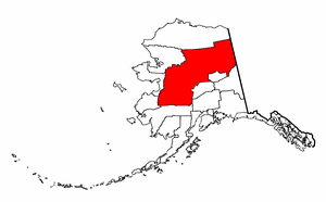
Yukon-Koyukuk Census Area, Alaska
|
|
Yukon-Koyukuk Census Area is a census area located in the state of Alaska. As of 2000, the population is 6,551. There is no borough seat.
| Contents |
Geography
The census area has a total area of 382,910 km² (147,843 mi²). 377,878 km² (145,900 mi²) of it is land and 5,032 km² (1,943 mi²) of it is water. The total area is 1.31% water. The area is roughly the same size as the U.S. state of Montana.
Adjacent boroughs and census areas
- North Slope Borough, Alaska - north
- Southeast Fairbanks Census Area, Alaska - southeast
- Fairbanks North Star Borough, Alaska - southeast
- Denali Borough, Alaska - southeast
- Bethel Census Area, Alaska - south
- Wade Hampton Census Area, Alaska - west
- Nome Census Area, Alaska - west
- Northwest Arctic Borough, Alaska - west
Also shares eastern border with the Yukon Territory, Canada.
Demographics
As of the census2 of 2000, there are 6,551 people, 2,309 households, and 1,480 families residing in the census area. The population density is 0.017/km² (0.045/mi²). There are 3,917 housing units at an average density of 0.010/km² (0.027/mi²). The racial makeup of the census area is 24.27% White, 0.09% Black or African American, 70.89% Native American, 0.37% Asian, 0.05% Pacific Islander, 0.43% from other races, and 3.91% from two or more races. 1.19% of the population are Hispanic or Latino of any race.
There are 2,309 households out of which 38.90% have children under the age of 18 living with them, 36.90% are married couples living together, 16.90% have a female householder with no husband present, and 35.90% are non-families. 30.50% of all households are made up of individuals and 6.20% have someone living alone who is 65 years of age or older. The average household size is 2.81 and the average family size is 3.53.
In the census area the population is spread out with 35.00% under the age of 18, 8.70% from 18 to 24, 26.90% from 25 to 44, 22.10% from 45 to 64, and 7.30% who are 65 years of age or older. The median age is 31 years. For every 100 females there are 118.60 males. For every 100 females age 18 and over, there are 122.60 males.
Cities and towns
- Alatna
- Allakaket
- Anvik
- Arctic Village
- Beaver
- Bettles
- Birch Creek
- Central
- Chalkyitsik
- Circle
- Coldfoot
- Evansville
- Flat
- Fort Yukon
- Four Mile Road
- Galena
- Grayling
- Holy Cross
- Hughes
- Huslia
- Kaltag
- Koyukuk
- Lake Minchumina
- Livengood
- Manley Hot Springs
- McGrath
- Minto
- Nenana
- New Allakaket
- Nikolai
- Nulato
- Rampart
- Ruby
- Shageluk
- Stevens Village
- Takotna
- Tanana
- Venetie
- Wiseman
| Regions of Alaska | Missing image Alaska_state_flag.png Flag of Alaska |
|---|---|
| Alaskan Bush | Interior | North Slope | Panhandle | South Central | Tanana Valley | |
| Largest cities | |
| Anchorage | Barrow | Bethel | Fairbanks | Homer | Juneau | Kenai | Ketchikan | Kodiak | Kotzebue | Nome | Palmer | Petersburg | Seward | Sitka | Unalaska | Valdez | Wasilla | |
| Boroughs and census areas | |
| Aleutians East | Aleutians West | Anchorage | Bethel | Bristol Bay | Denali | Dillingham | Fairbanks North Star | Haines | Juneau | Kenai Peninsula | Ketchikan Gateway | Kodiak Island | Lake and Peninsula | Matanuska-Susitna | Nome | North Slope | Northwest Arctic | Prince of Wales - Outer Ketchikan | Sitka | Skagway-Hoonah-Angoon | Southeast Fairbanks | Valdez-Cordova | Wade Hampton | Wrangell-Petersburg | Yakutat | Yukon-Koyukuk |

