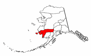
Bethel Census Area, Alaska
|
|
Bethel Census Area is a census area located in the U.S. state of Alaska. As of 2000, the population is 16,006. The census area has no borough seat.
| Contents |
Geography
The census area has a total area of 117,866 km² (45,508 mi²). 105,240 km² (40,633 mi²) of it is land and 12,627 km² (4,875 mi²) of it is water. The total area is 10.71% water.
Adjacent boroughs and census areas
- Wade Hampton Census Area, Alaska - northwest
- Yukon-Koyukuk Census Area, Alaska - north
- Matanuska-Susitna Borough, Alaska - east
- Kenai Peninsula Borough, Alaska - southeast
- Lake and Peninsula Borough, Alaska - south
- Dillingham Census Area, Alaska - south
Demographics
As of the census2 of 2000, there are 16,006 people, 4,226 households, and 3,173 families residing in the census area. The population density is 0/km² (0/mi²). There are 5,188 housing units at an average density of 0/km² (0/mi²). The racial makeup of the census area is 12.53% White, 0.38% Black or African American, 81.93% Native American, 1.05% Asian, 0.06% Pacific Islander, 0.19% from other races, and 3.85% from two or more races. 0.87% of the population are Hispanic or Latino of any race.
There are 4,226 households out of which 51.00% have children under the age of 18 living with them, 50.20% are married couples living together, 15.20% have a female householder with no husband present, and 24.90% are non-families. 19.90% of all households are made up of individuals and 2.80% have someone living alone who is 65 years of age or older. The average household size is 3.73 and the average family size is 4.41.
In the census area the population is spread out with 39.80% under the age of 18, 9.70% from 18 to 24, 28.90% from 25 to 44, 16.40% from 45 to 64, and 5.20% who are 65 years of age or older. The median age is 25 years. For every 100 females there are 113.20 males. For every 100 females age 18 and over, there are 112.80 males.
Bethel Census Area is one of only 38 county-level census divisions of the United States where the most spoken language is not English and one of only 3 where it is neither English nor Spanish. 62.97% of the population speak Yupik at home, followed by English at 34.62%.
Cities and towns
- Akiachak
- Akiak
- Aniak
- Atmautluak
- Bethel
- Chefornak
- Chuathbaluk
- Crooked Creek
- Eek
- Goodnews Bay
- Kasigluk
- Kipnuk
- Kongiganak
- Kwethluk
- Kwigillingok
- Lime Village
- Lower Kalskag
- Mekoryuk
- Napakiak
- Napaskiak
- Newtok
- Nightmute
- Nunapitchuk
- Oscarville
- Platinum
- Quinhagak
- Red Devil
- Sleetmute
- Stony River
- Toksook Bay
- Tuluksak
- Tuntutuliak
- Tununak
- Upper Kalskag
| Regions of Alaska | Missing image Alaska_state_flag.png Flag of Alaska |
|---|---|
| Alaskan Bush | Interior | North Slope | Panhandle | South Central | Tanana Valley | |
| Largest cities | |
| Anchorage | Barrow | Bethel | Fairbanks | Homer | Juneau | Kenai | Ketchikan | Kodiak | Kotzebue | Nome | Palmer | Petersburg | Seward | Sitka | Unalaska | Valdez | Wasilla | |
| Boroughs and census areas | |
| Aleutians East | Aleutians West | Anchorage | Bethel | Bristol Bay | Denali | Dillingham | Fairbanks North Star | Haines | Juneau | Kenai Peninsula | Ketchikan Gateway | Kodiak Island | Lake and Peninsula | Matanuska-Susitna | Nome | North Slope | Northwest Arctic | Prince of Wales - Outer Ketchikan | Sitka | Skagway-Hoonah-Angoon | Southeast Fairbanks | Valdez-Cordova | Wade Hampton | Wrangell-Petersburg | Yakutat | Yukon-Koyukuk |

