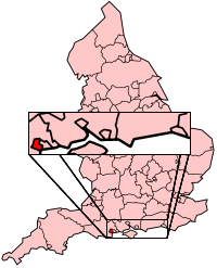
Poole
|
|
| Borough of Poole | |
|---|---|

| |
| Geography | |
| Status: | Unitary, Borough |
| Region: | South West England |
| Ceremonial County: | Dorset |
| Area: - Total | Ranked 285th 64.88 km² |
| Admin. HQ: | Poole |
| ONS code: | 00HP |
| Demographics | |
| Population: - Total (2003 est.) - Density | Ranked 127th 137,519 2,120 / km² |
| Ethnicity: | 98.2% White |
| Politics | |
| Borough of Poole http://www.poole.gov.uk/ | |
| Leadership: | Leader & Cabinet |
| Executive: | Conservative |
| MPs: | Annette Brooke, Robert Syms |
Poole is a coastal town, port and tourist destination in the traditional county of Dorset in southern England. The town has a population of 138,299 (2001). The town is situated beside a large natural harbour, on the shores of the English Channel. The town is part of a conurbation with Bournemouth a slightly larger but much younger neighbouring coastal town.
Poole is positioned on a very popular stretch of coastline, with the resort of Bournemouth to the east, Studland to the south and the Jurassic coast southwest. The town has grown rapidly, and Sandbanks, a small sand spit across part of the harbour mouth, is so popular that it has the fourth highest land value, by area, in the world. There are exclusive homes both on Sandbanks and the whole of the area stretching east from the Harbour to The Avenue (the eastern boundary of Poole).
Prominent employers in Poole include Barclays Bank, Hamworthy Engineering, Poole Packaging, Sunseeker and Ryvita.
| Contents |
Harbour
Main article: Poole Harbour.
Poole Harbour (said to be the second largest natural harbour in the world after Sydney) has been a working port for many hundreds of years, though the port has declined somewhat as the shallow water cannot take the largest ships. The harbour is noted for its ecology, supporting varied habitats as well as the Brownsea Island nature reserve, where the Scouting movement began. Today the port is amongst other things the home of Sunseeker, manufacturers of luxury yachts, and the departure point for ferries (Brittany Ferries, Condor and Truckline) to France. The quayside and harbour was the place from which some ships departed for the D-Day landings of World War 2.
History
The Poole Harbour area has been inhabited for well over 2,000 years. The local tribe were the Celtic Durotriges who lived in Dorset in the Iron Age, particularly around Wareham, five miles to the west. The earliest significant archaeological find in the harbour itself is the Poole Longboat, a 10 metre boat made from a single oak tree and dating to 295 BCE. At the time the harbour was probably shallower and any settlement would now be under water. During the last few centuries before the Roman invasion the Celtic people were moving from the hilltop settlements, such as Maiden Castle and Badbury Rings on the chalk downs to the north, and onto the lower vales and heathland around the River Frome. It may be this marshy area which gave the Durotriges, "water dwellers", their name. The Durotriges probabaly engaged in cross-chanel trading at Poole with the Veneti, a seafaring tribe from Brittany.
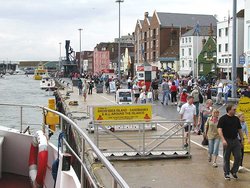
Missing image Poole.viewfromharbour.arp.jpg The waterfront from the harbour |
Missing image Poole.sunseeker.arp.jpg The main Sunseeker factory on the Poole waterfront. The company, employing 1400 people, makes luxury motor-yachts, one of which is seen outside (with the dark blue hull) |
In the Roman invasion of Britain in the 1st century, Poole was one of a number of harbouring sites along the south coast where the Romans landed. The Romans founded Hamworthy, an area just west of the modern town centre, and continued to use the harbour during the occupation.
Poole was a small fishing village at the time of the Norman Conquest, but grew rapidly into an important port exporting Wool, and in 1433 was made Port of the Staple. By then the town had trade links from the Baltic to Spain. In the 17th century transatlantic trade and travel developed and at the start of the 18th century Poole was beating rival Bristol as the busiest port in England. The town grew rapidly during the industrial revolution as urbanisation took place, and the merchants put up tenement buildings (mostly demolished in the 1960s).
At the turn of the 19th century 9 out of 10 workers in Poole were engaged in harbour activities but as the century progressed ships became too large for the shallow harbour and the port began losing business to the deepwater ports at Liverpool, Southampton and Plymouth.
In the 19th century the beaches and landscape of south west Hampshire and the Isle of Purbeck district of Dorset began to attract large numbers of tourists and the village of Bournemouth, five miles east of Poole, grew as a holiday town. Growth accelerated and Poole and Bournemouth have become a single conurbation, though Poole remains the more industrial part of the conurbation.
The town centre has many of the old buildings put up by the wealthy merchants, such as the 1761 market house and Sir Peter Thompson's 1746 town house designed by John Bastard. The 18th and 20th century buildings hide earlier buildings, such as the medieval granary and Scaplen's House and the Tudor almshouses. However, the town suffered both from bombing in World War II and the utilitarian town planning of the economically drained post-war Britain, and has lost many old buildings. In recent years, however, some regeneration has taken place, with the demolition of Hamworthy power station and some decaying old warehouses and 1960s tower blocks.
On April 1, 1997 the town was made a unitary authority, administratively independent from Dorset.
Culture, Recreation and Entertainment
Poole Harbour is a popular location for watersports because it is sheltered and calm. Poole Harbour is also one of the largest centres for sailing in the UK with many yacht clubs including Lilliput Sailing Club, Parkstone Yacht Club and Poole Yacht Club.
Poole is also noted for its motorcycle speedway team, the Poole Pirates.
Poole has a variety of entertainment sites, from the out-of-town development Tower Park, the refurbished arts centre now known as The Lighthouse, Poole town centre itself and Bournemouth's many clubs, bars and restaurants.
Places of interest
- Brownsea Island
- Compton Acres Gardens
- Poole Pottery.
External links
- Poole Borough Council (http://www.poole.gov.uk/)
- Poole Tourism (http://www.pooletourism.com/)
- Map of poole (http://www.poole.gov.uk/cgi-bin/map2.pl?unit_name=map&act=towncentre&style=borough)
References
- Cochrane, C, 1970. Poole Bay and Purbeck, 300BC to AD1660. Dorchester, Longmans.
- Pitt-Rivers, Michael, 1968. Dorset. London: Faber & Faber
- Poole Harbour Commission, The history of Poole Harbour (http://www.abu11.dial.pipex.com/history.htm) (accessed 2004/11/09)
| Districts of England - South West England | 
|
|
Bath and North East Somerset | Bournemouth | Bristol | Caradon | Carrick | Cheltenham | Christchurch | Cotswold | East Devon | East Dorset | Exeter | Forest of Dean | Gloucester | Isles of Scilly | Kennet | Kerrier | Mendip | Mid Devon | North Cornwall | North Devon | North Dorset | North Somerset | North Wiltshire | Penwith | Plymouth | Poole | Purbeck | Restormel | Salisbury | Sedgemoor | South Gloucestershire | South Hams | South Somerset | Stroud | Swindon | Taunton Deane | Teignbridge | Tewkesbury | Torbay | Torridge | West Devon | West Dorset | West Somerset | West Wiltshire | Weymouth and Portland | |
|
Administrative counties with multiple districts: Cornwall - Devon - Dorset - Gloucestershire - Somerset - Wiltshire |

