Loma Prieta earthquake
|
|
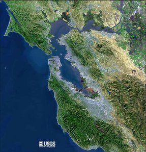
The Loma Prieta earthquake occurred on October 17, 1989 in the greater San Francisco Bay Area in California at 5:04 pm local time and measured 7.1 on the Richter magnitude scale (6.9 on the Moment magnitude scale). The earthquake lasted for fifteen seconds. Its epicenter was at 37.04° N latitude, 121.88° W longitude near Loma Prieta Peak in the Santa Cruz Mountains, about ten miles (16 km) northeast of the town of Santa Cruz, California, in the Forest of Nisene Marks State Park.
Cypress_structure.jpeg
This was a major earthquake which caused severe damage as far as 70 miles (110 km) away — most notably in San Francisco, Oakland, the San Francisco Peninsula, and in areas closer to the epicenter in the communities of Santa Cruz, Watsonville, and Los Gatos. Most of the major property damage in the more distant areas resulted from liquefaction of soil used over the years to fill in the waterfront and then built upon.
| Contents |
Science, Effects and Response
The magnitude and distance of the earthquake from the severe damage to the north were surprising to geotechnologists. Subsequent analysis indicates that the damage was likely due to reflected seismic waves - the reflection from well-known deep (about fifteen miles) discontinuities in the earth's gross structure.
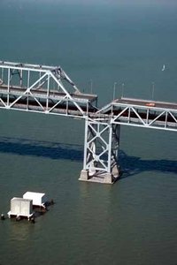
There were at least 66 deaths and 3,757 injuries as a result of this earthquake. The highest concentration of fatalities, 42, occurred in the collapse of the Cypress structure on the Nimitz Freeway (Interstate 880), where a double-decker portion of the freeway collapsed, crushing the cars on the lower deck. One 50-foot (15 m) section of the San Francisco-Oakland Bay Bridge also collapsed, causing two cars to fall to the deck below, leading to the single fatality on the bridge. The bridge was closed for repairs for a month and one day, reopening on November 18. While the bridge was closed, ridership on Bay Area Rapid Transit soared.
Because this quake occurred during the evening rush hour, there could have been a large number of cars on the freeways at the time, which on the Cypress structure could have endangered many hundreds of commuters. Very fortunately, and in an unusual convergence of events, the two local major league baseball teams (the Oakland Athletics and the San Francisco Giants) were about to start their third game of the World Series (the game was scheduled to start shortly after 5:30 pm). Many people had left work early or were participating in early after-work group viewings and parties. As a consequence, the usually crowded highways were experiencing exceptionally light traffic at the time.
Extensive damage also occurred in San Francisco's Marina District, where many expensive homes built on filled ground collapsed. Fires raged in some sections of the city as water mains broke. San Francisco's fireboat (the Phoenix) was used to pump salt water from San Francisco Bay through hoses dragged through streets by citizen volunteers. Power was cut to most of San Francisco and was not fully restored for several days.
Deaths in Santa Cruz occurred when brick storefronts and sidewalls in the historic downtown (what was then called the Pacific Garden Mall) tumbled down on people exiting the buildings.
The quake also caused an estimated $6 billion in property damage, the most costly natural disaster in U.S. history at the time. It was the largest earthquake to occur on the San Andreas Fault since the great San Francisco earthquake in April 1906. Private donations poured in to aid relief efforts and on October 26, President Bush signed a $3.45 billion earthquake relief package for California.
Bayas89mABAGLomaPrietaScaled.gif
Transportation Effects
The Loma Prieta earthquake irrevocably changed the San Francisco Bay Area's transportation landscape. Not only did the quake force the seismic retrofit of all the bridges around the San Francisco Bay, it caused enough damage that some parts of the region's freeway system had to be demolished. In some cases, the freeways in question had never been completed, terminating in mid-air; in that regard, the quake provided the impetus to deal with regional transportation problems that had gone largely unsolved for decades.
- San Francisco-Oakland Bay Bridge, Interstate 80: The Bay Bridge was repaired and reopened to traffic in just one month's time. However, the earthquake made it clear that the Bay Bridge, like many of California's toll bridges, required major repair or replacement, for long-term viability and safety. Construction on a replacement for the eastern span would not begin, however, until January 29, 2002. As of 2005, news accounts estimate that the project will not be completed by 2011 due to the California budget crisis. (For discussion, see also San Francisco-Oakland Bay Bridge).
- Cypress Structure/Nimitz Freeway, Interstate 880: The double-decked "Cypress Structure", Interstate 880, was demolished soon after the earthquake, and was not rebuilt until July 1997. The rebuilt highway was no longer a double-decker structure, and it was constructed around the outskirts of West Oakland, rather than bisecting it, as the Cypress structure did.
- Embarcadero Freeway, California State Route 480: The earthquake forced the closure and demolition of San Francisco's largely unloved Embarcadero Freeway (State Highway 480); this demolition opened up San Francisco's Embarcadero waterfront to new development. The concrete freeway, which ran right along San Francisco's waterfront and had never been completed, was replaced with a ground-level boulevard.
- Southern Freeway, Interstate 280: Seismic damage also forced the long-term closure of Interstate 280 in San Francisco (north of US-101), another concrete freeway which had never been completed to its originally planned route. The highway remained closed for seven years, with its repair facing numerous delays.
- Central Freeway, U.S. Highway 101: San Francisco's Central Freeway (part of US 101) was another concrete double-deck structure which faced demolition due to safety concerns. Originally terminating at Franklin Street near San Francisco's Civic Center, the section past Fell Street was demolished first, then later the section between Mission and Fell Streets. A new section connecting the freeway from Mission Street to Market Street is under construction, which will end at a ground-level boulevard along Octavia Street, carrying traffic to both Fell and Franklin Streets.
- Highway 17, California State Route 17: The mountain highway was closed for about 1 month due to landslide. The highway is very close to the epicenter and it crosses the San Andreas Fault.
1989 World Series
The earthquake had been predicted in the morning edition of the San Jose Mercury News in Kevin Cowherd's column. He was discussing the fact that the Oakland Athletics and the San Francisco Giants were playing each other in the 1989 World Series at Candlestick Park that day. The quote from his column read: "... these are two teams from California and God only knows if they'll even get all the games in. An earthquake could rip through the Bay Area before they sing the national anthem for Game 3,"—which was precisely when the quake occurred.
Fortunately, less than half of the 65,000+ fans had reached their seats, lessening the load on the structure of the stadium. There had also been a seismic strengthening project previously completed on the upper deck concrete windscreen. Fans reported that the stadium moved in an articulated manner as the earthquake wave passed through it, that the light standards swayed by many feet, and that the concrete upper deck windscreen moved in a wave-like manner over a distance of several feet. When the shaking stopped, the assembled crowd roared, "Play Ball, Play Ball!" Regardless, the game was called and the Series was postponed for 10 days.
External links
Seismology
- USGS: Loma Prieta (http://neic.usgs.gov/neis/eq_depot/usa/1989_10_18.html)
- USGS list of additional Loma Prieta sites (http://neic.usgs.gov/neis/states/california/loma_prieta.html)
- Selected USGS photographs from the Loma Prieta earthquake (http://wrgis.wr.usgs.gov/dds/dds-29/)
- Progress Toward a safer future since the 1989 Loma Prieta Earthquake (http://geopubs.wr.usgs.gov/fact-sheet/fs151-99/)
Transportation
- 15 Seconds That Changed San Francisco (http://sfgate.com/n/s/p/2004/city/), San Francisco Chronicle, October 17, 2004. Overview with photographs; analysis of changes between 1989 and 2004.


