Himalaya
|
|
The Himalaya is a mountain range in Asia, separating the Indian subcontinent from the Tibetan Plateau. By extension, it is also the name of the massive mountain system which includes the Himalaya proper, the Karakoram, the Hindu Kush, and a host of minor ranges extending from the Pamir Knot. Together, the Himalayan mountain system is the planet's highest and home to all 14 of the world's highest peaks, the Eight-thousanders, including Mount Everest. To comprehend the enormous scale of Himalayan peaks, consider that Aconcagua at 22,841 feet (6962 m) is the highest mountain in the Andes, while there are over thirty peaks in the Himalaya exceeding 25,000 feet (7620 m). Etymologically Himalaya means "abode of snow" in Sanskrit ( from hima "snow", and aalaya "abode"). The correct name for the range is Himalaya, though the plural Himalayas is often used.
The Himalaya stretch across five nations — Pakistan, India, China, Bhutan and Nepal. It is the source of two of the world's major river systems — the Indus Basin and the Ganga-Brahmaputra Basin. An estimated 750 million people live in the watershed area of the Himalayan rivers, which also includes Bangladesh.

| Contents |
Geography
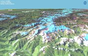
The Himalayan range runs for about 2400 km, from Nanga Parbat in the west to Namche Barwa in the east. The width varies between 250-300 km. The Himalayan range comprises three parallel ranges, arranged by elevation and geological age.

Vegetation across the Himalayan range varies with climate and altitude. While the sub-Himalayan range exhibits deciduous forests, the vegetation graduates to temperate forests, conifers and tundra in the Higher Himalayan range, before giving way to a permanent snow line in the topmost regions. The far eastern Himalaya also have evergreen rainforests.
The Indian states of Jammu and Kashmir, Himachal Pradesh, Uttaranchal, Sikkim and Arunachal Pradesh lie mostly in the Himalayas.
Origins and growth
Main article: Geology of the Himalaya
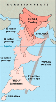
The Himalaya are among the youngest mountain ranges on the planet. According to the modern theory of plate tectonics, their formation is a result of a continental collision or orogeny along the convergent boundary between the Indo-Australian Plate and the Eurasian Plate. The collision began in the Upper Cretaceous period about 70 million years ago, when the north-moving Indo-Australian Plate, moving at about 15 cm/year, collided with the Eurasian Plate. By about 25 million years ago this fast moving Indo-Australian plate had completely closed the Tethys Ocean, whose existence has been determined by sedimentary rocks settled on the ocean floor and the volcanoes that fringed its edges. Since these sediments were light, they crumpled into mountain ranges rather than sinking to the floor. The Indo-Australian plate continues to be driven horizontally below the Tibetan plateau, which forces the plateau to move upwards. The Arakan Yoma highlands in Myanmar and the Andaman and Nicobar Islands in the Bay of Bengal were also formed as a result of this collision.
The Indo-Australian plate is still moving at about 2 cm/year, and over the next 10 million years it will travel more than 180 km into Tibet. This leads to the Himalaya rising by about 5 mm/year, making them geologically active. The movement of the Indian plate into the Asian plate also makes this region seismically active, leading to earthquakes from time to time.
Glaciers and river systems
The Himalayan range encompasses a very large number of glaciers, notable among which is the Siachen Glacier, the largest in the world outside the polar region. Some of the other more famous glaciers include the Gangotri and Yamunotri (Uttaranchal), Nubra, Biafo and Baltoro (Karakoram region), Zemu (Sikkim) and Khumbu glaciers (Mount Everest region).

The higher regions of the Himalaya are snowbound throughout the year in spite of their proximity to the tropics, and they form the sources for several large perennial rivers, most of which combine into two large river systems:
- The western rivers combine into the Indus Basin, of which the Indus River is the largest. The Indus begins in Tibet at the confluence of Sengge and Gar rivers and flows southwest through Pakistan to the Arabian Sea. It is fed by the Jhelum, the Chenab, the Ravi, the Beas, and the Sutlej rivers, among others.
- Most of the other Himalayan rivers drain the Ganga-Brahmaputra Basin. Its two main rivers are the Ganges and the Brahmaputra. The Ganga originates as the Bhagirathi from the Gangotri glacier and flows southeast through the plains of northern India, fed by the Alaknanda and the Yamuna among other tributaries. The Brahmaputra originates as the Tsangpo in western Tibet, and flows east through Tibet and west through the plains of Assam. The Ganga and the Brahmaputra meet in Bangladesh, and drain into the Bay of Bengal through the world's largest river delta.
The eastern-most Himalayan rivers feed the Irrawaddy, which originates in eastern Tibet and flows south through Myanmar to drain into the Andaman Sea.
The Salween, Mekong, the Yangtze and the Huang He (Yellow River) all originate from parts of the Tibetan plateau that are geologically distinct from the Himalaya mountains, and are therefore not considered true Himalayan rivers. Some geologists refer to all the rivers collectively as the circum-Himalayan rivers [1] (http://www.cosis.net/abstracts/EAE03/13617/EAE03-J-13617.pdf).
Lakes
Tsongmolake.jpg
Gdm.jpg
The mountain lakes are known to geographers as tarns if they are caused by glacial activity. Tarns are found mostly in the upper reaches of the Himalaya, above 5,500 metres.
Impact on climate
The Himalaya has a profound effect on the climate of the Indian subcontinent and the Tibetan plateau. It prevents frigid, dry Arctic winds from blowing south into the subcontinent, which keeps South Asia much warmer than corresponding temperate regions in the other continents. It also forms a barrier for the monsoon winds, keeping them from traveling northwards, and causing heavy rainfall in the Terai region. The Himalaya are also believed to play an important part in the formation of Central Asian deserts such as the Taklamakan and Gobi deserts.
Thermal_Equator.jpg
Due to the mountain ranges, the western disturbances which appear from Iran during winter are prevented from travelling any further, resulting in snow in Kashmir and rainfall for parts of Punjab and northern India. Despite being a barrier to the cold northernly winter winds, the Brahmaputra valley receives part of the frigid winds, thus lowering the temperature in the northeast Indian states and Bangladesh. These winds also cause the North East monsoon during this season for these parts.
Mountain passes
The rugged terrain means there are few routes over the Himalaya.
- Gangtok in Sikkim to Lhasa in Tibet via the Nathula Pass and Jelepla Passes (offshoots of the ancient Silk Route).
- Bhadgaon in Nepal to Nyalam in Tibet.
- Rohtang Pass in Himachal Pradesh, India
- The road from Srinagar in Kashmir via Leh to Tibet is now less used because of the troubles in the region.
Impact on politics and culture
Yumthang.jpg
The Himalaya, due to its large size and expanse, has been a natural barrier to the movement of people for a long time. In particular, this has prevented intermingling of people from the Indian subcontinent with people from China and Mongolia, causing significantly different languages and customs between these regions. The Himalaya has also hindered trade routes and prevented military expeditions across its expanse. For instance, Genghis Khan could not expand his empire south of the Himalaya into the subcontinent.
Himal
Himal is Nepalese for "range" and is used to name the various regions of the Himalaya. In Nepal, these are as follows:
- Annapurna Himal
- Ganesh Himal
- Khumbu Himal
- Langtang Himal
- Manang Himal
- Rolwaling Himal
Notable peaks
| Peak Name | Elevation (m) | Elevation (ft) |
|---|---|---|
| Everest | 8,850 | 29,035 |
| K2 | 8,611 | 28,251 |
| Kanchenjunga | 8,586 | 28,169 |
| Lhotse | 8,501 | 27,939 |
| Makalu | 8,462 | 27,765 |
| Cho Oyu | 8,201 | 26,906 |
| Dhaulagiri | 8,167 | 26,764 |
| Manaslu | 8,163 | 26,758 |
| Nanga Parbat | 8,126 | 26,658 |
| Annapurna | 8,091 | 26,545 |
| Gasherbrum I | 8,068 | 26,470 |
| Broad Peak | 8,047 | 26,400 |
| Gasherbrum II | 8,035 | 26,360 |
| Shishapangma | 8,027 | 26,289 |
| Gyachung Kang | 7,922 | 26,089 |
| Nanda Devi | 7,817 | 25,645 |
| Kabru | 7,338 | 24,258 |
| Pumori | 7,161 | 23,494 |
Religion and mythology
Several places in the Himalaya are of religious significance in Hinduism and Buddhism. In Hinduism, the Himalaya have also been personified as the god Himavat, the father of Shiva's consort, Parvati.
Kumbh_mela_at_haridwar.jpg
- Haridwar, the place where the river Ganges enters the plains.
- Badrinath, a temple dedicated to Vishnu.
- Kedarnath, where one of the 12 Jyothirlingas is located.
- Deoprayag, where the Alaknanda and Bhagirathi merge to form the Ganges.
- Rishikesh, has a temple of Lakshmana.
- Mount Kailash, a 6,718 m high peak which is considered to be the abode of the Hindu god Shiva and is also venerated by Buddhists. Lake Manasarowar lies at the base of Mount Kailash, and is the source of the Brahmaputra.
- Amarnath, has a natural Shivalinga of ice which forms for a few weeks each year. Thousands of people visit this cave during these few weeks.
- A number of Tibetan Buddhist sites are situated in the Himalaya, including the residence of the Dalai Lama.
- The Yeti is one of the most famous creatures in cryptozoology. It is a large primate-like creature that is supposed to live in the Himalaya. Most mainstream scientists and experts consider current evidence of the Yeti's existence unpersuasive, and the result of hoaxes, legend or misidentification of mundane creatures.
- Shambhala is a mystical city in Buddhism with various legends associated with it. While some legends consider it to be a real city where secret Buddhist doctrines are being preserved, other legends believe that the city does not physically exist and can only be reached in the mental realm.
Himalaya in fiction
- Shangri-La is a fictional utopia situated somewhere in the Himalaya, based on the legendary Shambhala. It is described in the novel Lost Horizon, written by the British writer James Hilton in 1933.
- The Hollywood movie Vertical Limit (2000), is set in the K2 peak of the Himalaya.
See also
- Eight-thousander - a list of Himalayan peaks over 8000 metres
- List of mountains in Pakistan
- Geography of China
- Trekking peak
External links
- The making of the Himalaya and major tectonic subdivisions (http://comp1.geol.unibas.ch/zanskar/CHAPITRE2/page23.html)
- Geology of the Himalayan mountains (http://jan.ucc.nau.edu/~wittke/Tibet/Himalaya.html)
- Birth of the Himalaya (http://www.pbs.org/wgbh/nova/everest/earth/birth.html)
- Some notes on the formation of the Himalaya (http://snobear.colorado.edu/Markw/Mountains/03/week11.html)bg:Хималаи
ca:Himàlaia da:Himalaya de:Himalaya et:Himaalaja es:Himalaya eo:Himalajo fr:Himalaya io:Himalaia id:Himalaya it:Himalaya he:הימלאיה kn:ಹಿಮಾಲಯ ms:Himalaya nl:Himalaya ne:हिमालय ja:ヒマラヤ山脈 no:Himalaya pl:Himalaje pt:Himalaia ru:Гималаи sa:हिमालय sl:Himalaja sr:Хималаји fi:Himalaja sv:Himalaya th:เทือกเขาหิมาลัย uk:Гімалаї zh:喜马拉雅山脉


