Geography of Brazil
|
|
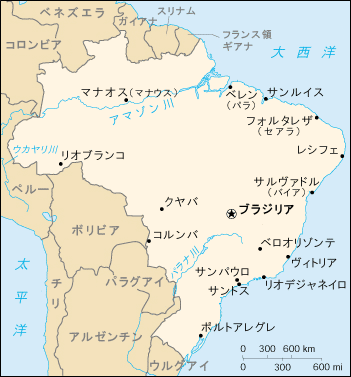
The country of Brazil occupies a large portion of eastern South America, bordering the Atlantic Ocean. Brazil covers a total area of 8,514,215 km² (3,287,357 sq. mi) which includes 8,456,510 km² (3,265,076 sq. mi) of land and 55,455 km² (21,411 sq. mi) of water. The highest point in Brazil is Pico da Neblina at 3,014 m (9,888 ft); the lowest point is sea level. Brazil is bordered by the countries of Argentina, Bolivia, Colombia, French Guiana, Guyana, Paraguay, Peru, Suriname, Uruguay and Venezuela. By comparison, Brazil is slightly smaller in land mass than the United States.
Much of the climate is tropical, though some areas may be more temperate. The largest river in Brazil, and one of the longest in the world is the Amazon. The rainforest that covers the Amazon Basin constitutes almost half of the rainforests on Earth.
| Contents |
Physical Geography
Terrain: mostly flat to rolling lowlands in north; some plains, hills, mountains, and narrow coastal belt
Geology
Mountains and Hills
Rivers and Lakes
The River Amazon is the widest and second longest river in the world. This huge river waters the majority of the world's rainforests. Another rather large river called the Parana, which has its source in Brazil. It forms the border of Peru and Argentina, then winds its way through Argentina and into the Atlantic Ocean along Uruguay.
Coastline
Coastline: 7,367 km (4578 mi)
Climate
Climate: mostly tropical, but temperate in south
Human Geography
Demographics
Main article: Demographics of Brazil
Economic Geography
Main article: Economy of Brazil
Natural Resources
Natural resources include bauxite, gold, iron ore, manganese, nickel, [[phosphates]platinum, tin, uranium, petroleum, hydropower and timber, [{my nuts}]
Environment
Environment - current issues:
deforestation in Amazon Basin destroys the habitat and endangers the existence of a multitude of plant and animal species indigenous to the area; air and water pollution in Rio de Janeiro, São Paulo, and several other large cities; land degradation and water pollution caused by improper mining activities
note:
President Cardoso in September 1999 signed into force an environmental crime bill which for the first time defines pollution and deforestation as crimes punishable by stiff fines and jail sentences
Environment - international agreements:
party to:
Antarctic-Environmental Protocol, Antarctic-Marine Living Resources, Antarctic Seals, Antarctic Treaty, Biodiversity, Climate Change, Climate Change-Kyoto Protocol, Desertification, Endangered Species, Environmental Modification, Hazardous Wastes, Law of the Sea, Marine Dumping, Ozone Layer Protection, Ship Pollution, Tropical Timber 83, Tropical Timber 94, Wetlands, Whaling
signed, but not ratified:
none of selected agreements
Geographic coordinates:
Template:Coor d
Map references: South America
Area:
total:
8,514,215 km² (3,287,357 sq. mi)
land:
8,456,510 km² (3,265,076 sq. mi)
water:
55,455 km² (21,411 sq. mi)
note:
includes Arquipelago de Fernando de Noronha, Atol das Rocas, Ilha da Trindade, Ilhas Martin Vaz, and Penedos de São Pedro e São Paulo.
Special Note: About 60% of the Amazon Rainforest is part of Brazil.
Area - comparative: slightly smaller than the US
Land boundaries:
total:
15,735 km (9777 mi)
border countries:
Argentina 1,263 km (785 mi), Bolivia 3,126 km (1942 mi), Colombia 1,644 km (1022 mi), French Guiana 655 km (407 mi), Guyana 1,298 km (807 mi), Paraguay 1,339 km (832 mi), Peru 2,995 km (1861 mi), Suriname 593 km (368 mi), Uruguay 1,003 km (623 mi), Venezuela 1,819 km (
1130 mi)
Maritime claims:
contiguous zone:
24 nautical miles
continental shelf:
200 nautical miles
exclusive economic zone:
200 nautical miles
territorial sea:
12 nautical miles
Vegetation: Cerrado, Atlantic Forest
Elevation extremes:
lowest point:
Atlantic Ocean 0 m
highest point:
Pico da Neblina 3,014 m (9,888 ft)
Land use:
arable land:
5%
permanent crops:
1%
permanent pastures:
22%
forests and woodland:
58%
other:
14% (1993 est.)
Irrigated land: 28,000 km² (1993 est.)
Natural hazards: recurring droughts in northeast; floods and occasional frost in south
Geography - note:
largest country in South America; shares common boundaries with every South American country except Chile and Ecuador
Cities
This is an incomplete list of Brazillian cities.
Fortaleza (http://www.ceara.com.br/fortaleza-2.htm)
See also
- History of Brazil
- Demographics of Brazil
- Politics of Brazil
- Economy of Brazil
- Communications in Brazil
- Transportation in Brazil
- Military of Brazil
- Foreign relations of Brazil
- States of Brazilfr:Géographie du Brésil
pl:Geografia Brazylii pt:Geografia do Brasil sl:Geografija Brazilije

