Cedar Breaks National Monument
|
|
| Cedar Breaks | |

| |
| Designation | U.S. National Monument |
| Location | Utah USA |
| Nearest City | Cedar City, Utah |
| Latitude | |
| Longitude | |
| Area | 6,155 acres 24.91 km² |
| Date of Establishment | 1933 |
| Visitation | 601,391 (2003) |
| Governing Body | National Park Service |
| IUCN category | III (National Monument) |
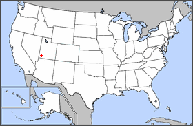
Cedar Breaks National Monument is located Near Cedar City Utah, United States. Cedar Breaks is a natural amphitheater canyon, stretching across 3 miles (5 km), and having a depth of over 2,000 feet (600 m). The elevation of the rim of the canyon is over 10,000 feet (3,000 m) above sea level.
The eroded rock of the canyon is similar to formations at Bryce Canyon, but has its own distinct look. Because of its elevation, snow oftem makes it inaccessible to vehicles from October through May. Its canyon-rim visitor center, tiny compared to nearby and better-known Bryce Canyon National Park and Zion National Park, is open only from June through October, although park headquarters at a lower elevation in Zion is open the rest of the year. It is not as popular as some of the other National Parks, but still, several hundred thousand people visit annually.
| Contents |
Flora and fauna
CedarBrMarmotFxCr_wb.jpg
Wildlife can often be seen, as there are not the crowds of people often found in the larger, better-known parks. Mule deer and porcupines are common, as are rodents and similar animals such as pikas, marmots, red squirrels, golden-mantled ground squirrels, pocket gophers, and chipmunks. Mountain lions and other larger animals live in the area but are seldom seen. Common birds include the Clark's nutcracker, Violet-green Swallows, and the Common Raven.
The bristlecone pine, a species of tree that lives longer than any other known thing, can also be found in the high country, with some local specimens known to be more than 1600 years old. Subalpine meadows dot the canyon rim in such areas as around Alpine Pond, which is within an easy hike from the road along a clear trail. Aspen, Engelmann Spruce, Subalpine Fir trees, and Limber Pine also grow here.
Spring begins in June at this elevation, when wildflowers cover the canyon rim. Wildflowers bloom all during the short growing season, and visitors can enjoy Indian Paintbrush, Lupine, Blue Columbine, Cinquefoil, Shootingstar, and wild rose, among others. In the earliest spring, Mountain Bluebell, spring beauty, Lavender Fleabane, Larkspur, and various Penstemons appear. The summer winds down with goldenrod and Asters.
Cedar_breaks_2.jpg
CedarBrVisitorCenter_wb.jpg
History and geology
Cedar_breaks_1.jpg
The amphitheater covers the west side of the Markagunt Plateau, the same plateau forming parts of Zion National Park. Uplift and erosion formed the canyon over millions of years, raising and then wearing away the shale, calcite limestone, and sandstone deposited at the bottom of an ancient lake about 55 million years ago. It continues to erode at a pace of about 12 cm a year (2 inches every 5 years). Atop the plateau, volcanic rock known as rhyolitic tuff covers much of the area, formed during cataclysmic eruptions around 28 million years ago.
The rocks of the eroded canyon contain iron and manganese in various combinations, providing brilliant colors that led Indians to call it the Circle of Painted Cliffs. Iron oxides provide the reds, oranges, and yellows, while manganese oxides provide shades of purple.
The area is another form of badlands—canyons, spires, walls, and cliffs so steep and confusing that the land is worth nothing except aesthetically. Early settlers called them badlands or breaksand created its current name by combining Breaks with cedar for the many juniper trees (often incorrectly called cedars) that grow in the area.
Cedar Breaks National Monument was established in 1933.
Attractions
There are several hiking trails throughout the park, and a campsite near the canyon rim.
References
- Cedar Breaks 1987 park brochure
- Alpine Trail brochure
External links
- [Cedar Breaks Official Website (http://www.nps.gov/cebr/)]
