California Trail
|
|
| Contents |
Description
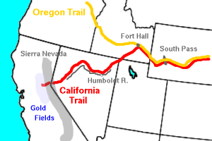
The exact route of the trail depended on the starting point of the voyage, the final destination in California, as well as the condition of livestock and vehicles. The main branch of the trail across the Great Plains was identical to the Oregon and Mormon trails, going up the Missouri River then crossing Nebraska along the Platte and North Platte to present-day Wyoming. The trail then followed the Sweetwater River across Wyoming, crossing the continental divide at South Pass (where it diverged from the Mormon Trail). From South Pass it went northwest to Fort Hall in the Oregon Country in present-day southeastern Idaho along the Snake River.
West of Fort Hall (near present day Pocatello, Idaho) at the junction of the Raft River and Snake River, the trail diverged from the Oregon Trail. The trail followed the Raft river southwest to near present day Almo, Idaho. It then passed through the City of Rocks and over Granite Pass where it followed southwest along Goose Creek, Little Goose Creek, and Rock Spring Creek. It passed through Thousand Springs Valley, and then along West Brush Creek to Willow Creek, then to the headwaters of the Humboldt River in present-day northwestern Nevada. The trail followed the north bank of the Humboldt across Nevada, passing through the narrow Carlin Canyon, which became nearly impassable during periods of high water. West of Carlin Canyon the trail climbed through Emigrant Pass then descended through Emigrant Canyon to rejoin the Humboldt at Gravelly Ford. At Gravelly Ford the trail divided into two branches, following the north and south banks of the river. The two branches rejoined at Humboldt Bar, where it diverged into several branches that crossed the Sierra Nevada to various destinations in California.
History
The area of the Great Basin through which the trail had passed had been only partially explored during the days of Spanish and Mexican rule. In 1834 Benjamin Bonneville, a United States Army officer on leave to pursue an expedition to the west financed by John Jacob Astor, sent Joseph Walker westward from the Green River in present-day Utah with the mission of finding a route to California. Walker discovered that the Humboldt River furnished a natural artery across the Great Basin.
Throughout the 1840s the trail began to be used sporadically by early settlers. The first recorded emigrant to use trail to reach California was John Bidwell, who led the 1841 Bidwell-Bartleson Party. Two years later in 1843, Joseph Chiles followed the same route. In 1844, Caleb Greenwwod and the Stephens-Townsend-Murphy Party became the first settlers to take wagons over the Sierra Nevada. In 1845, John C. Frémont and Lansford W. Hastings guided several a party of several hundred settlers along the trail to California. The following year Hastings persuaded another party of emigrants to follow his "shortcut" that ran to the south of the main route. One such, the Donner Party, became the most infamous group of emigrants to follow the trail.
The trickle of emigrants would become a flood after the discovery of gold in California in 1848, the same year that the U.S. acquired the Southwest in the Treaty of Guadalupe Hidalgo. Within several months of the public announcement of the discovery by President Polk in early 1849, thousands gold seekers were headed westward into take seek their fortunes in the newly acquired land.
Legacy
Part of the route of the trail across Nevada was used for the Central Pacific portion of the first transcontinental railroad. In the 20th century, the route was used for modern highways, in particular U.S. Highway 40 and later Interstate 80. Ruts from the wagon wheels and names of emigrants, written with axle grease on rocks, can still be seen in the City of Rocks National Reserve in southern Idaho.
External link
- NPS: California National Historical Trail (http://www.nps.gov/cali/)


