Districts of Serbia
|
|
Okruzi are the Districts of Serbia.
Okrug is a term to denote administrative subdivision in some Slavic states. Its etymology is similar to German Kreis, circle (in the meaning of administrative division) (although translated in German as Bezirk): okrug is literally something "encircling".
In subdivisions of Serbia, the term is translated as district, sometimes as county.
| Contents |
Serbia organization
The territorial order of the Republic of Serbia is regulated by the Law on Territorial Organization and Local Self-Government, adopted in the National Assembly on July 24, 1991. Under the Law, the municipalities, cities and settlements make the bases of the territorial organization.
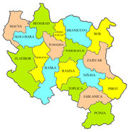
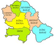
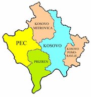
By its Enactment of 29 January 1992, the Government of the Republic of Serbia defined the state administration affairs that shall be run by the competent Ministries out of their seats, within the districts as regional centers of state authority. The Republic of Serbia is divided into 29 districts.
Districts
Central Serbia
- Bor
- Braničevo
- Jablanica
- Kolubara
- Mačva
- Moravica
- Nišava
- Pčinja
- Pirot
- Podunavlje
- Pomoravlje
- Raška
- Rasina
- Šumadija
- Toplica
- Zaječar
- Zlatibor
Vojvodina
Kosovo
| | Missing image Srcoa.gif Flag of Serbia |
|---|---|
|
North Bačka | South Bačka | West Bačka | North Banat | Central Banat | South Banat | Bor | Braničevo | Jablanica | Kolubara | Kosovo | Kosovo-Pomoravlje | Kosovska Mitrovica | Mačva | Moravica | Nišava | Pčinja | Peć | Pirot | Podunavlje | Pomoravlje | Prizren | Raška | Rasina | Srem | Šumadija | Toplica | Zaječar | Zlatibor | |
Note
All official material made by Government of Serbia is public by law. Information was taken from official website (http://www.serbia.sr.gov.yu/).


