|
|
| Statistics | |
|---|---|
| State: | Bavaria |
| Capital: | Erlangen |
| Adm. Region: | Mittelfranken |
| Area: | 565 km² |
| Inhabitants: | 128,900 (2000) |
| pop. density: | 228 inh./km² |
| Car identification: | ERH |
| Homepage: | erlangen-hoechstadt.de (http://www.erlangen-hoechstadt.de) |
| Map | |
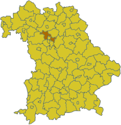
Erlangen-Höchstadt is a district in Bavaria, Germany. It is bounded by (from the south and clockwise) the districts of Fürth, Neustadt (Aisch)-Bad Windsheim, Bamberg, Forchheim and Nürnberger Land, and by the cities of Nuremberg and Erlangen. The city of Erlangen is not part of the district, but nonetheless its administrative seat.
| Contents [hide] |
History
The district was established in 1972 by merging the former districts of Erlangen and Höchstadt.
Geography
The main river is the Regnitz, which runs through the city of Erlangen. Lands west of the river are covered with several hundred tiny lakes on both sides of the Aisch. The Aisch is an affluent of the Regnitz, running from southwest to east. East of the river the country is rising to the hills of the northern Frankish Alb.
Coat of arms
| Missing image Erlangen_hoechstadt_coa.jpg Coat of arms | The coat of arms displays:
|
Towns and municipalities
| Towns | Municipalities | |
|---|---|---|
External link
- Official website (http://www.erlangen-hoechstadt.de) (German)


