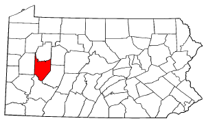
Armstrong County, Pennsylvania
|
|
Armstrong County is a county located in the U.S. state of Pennsylvania. As of 2000, the population is 72,392. It located northeast of Pittsburgh and Allegheny County. The county seat is Kittanning. The county was organized on March 12, 1800 from parts of Allegheny, Westmoreland and Lycoming Counties. It was named in honor of John Armstrong, Jr., who had represented Pennsylvania in the Continental Congress.
| Contents |
Geography
According to the U.S. Census Bureau, the county has a total area of 1,721 km² (664 mi²). 1,694 km² (654 mi²) of it is land and 27 km² (11 mi²) of it is water. The total area is 1.58% water.
Demographics
As of the census2 of 2000, there are 72,392 people, 29,005 households, and 20,535 families residing in the county. The population density is 43/km² (111/mi²). There are 32,387 housing units at an average density of 19/km² (50/mi²). The racial makeup of the county is 98.32% White, 0.82% Black or African American, 0.09% Native American, 0.12% Asian, 0.02% Pacific Islander, 0.13% from other races, and 0.50% from two or more races. 0.43% of the population are Hispanic or Latino of any race.
There are 29,005 households out of which 29.50% have children under the age of 18 living with them, 57.90% are married couples living together, 9.00% have a female householder with no husband present, and 29.20% are non-families. 25.90% of all households are made up of individuals and 13.70% have someone living alone who is 65 years of age or older. The average household size is 2.46 and the average family size is 2.95.
In the county, the population is spread out with 22.90% under the age of 18, 7.20% from 18 to 24, 27.60% from 25 to 44, 24.20% from 45 to 64, and 18.00% who are 65 years of age or older. The median age is 40 years. For every 100 females there are 94.70 males. For every 100 females age 18 and over, there are 92.10 males.
History
The County was named after Brigadier-General John Armstrong.
Municipalities
Cities
Boroughs
- Apollo
- Applewold
- Atwood
- Dayton
- Elderton
- Ford City
- Ford Cliff
- Freeport
- Kittanning
- Leechburg
- Manorville
- North Apollo
- Rural Valley
- South Bethlehem
- West Kittanning
- Worthington
Townships
- Bethel Township
- Boggs Township
- Bradys Bend Township
- Burrell Township
- Cadogan Township
- Cowanshannock Township
- East Franklin Township
- Gilpin Township
- Hovey Township
- Kiskiminetas Township
- Kittanning Township
- Madison Township
- Mahoning Township
- Manor Township
- North Buffalo Township
- Parks Township
- Perry Township
- Pine Township
- Plumcreek Township
- Rayburn Township
- Redbank Township
- South Bend Township
- South Buffalo Township
- Sugarcreek Township
- Valley Township
- Washington Township
- Wayne Township
- West Franklin Township
Census-designated places
Education
Colleges and Universities


