|
|
| Statistics | |
|---|---|
| Capital: | Macapá |
| Area: | 142 816 km²
Ranked 18th |
| Inhabitants: | 477 032 (2002)
Ranked 26th |
| Pop. density: | 3.3 inh./km²
Ranked 24th |
| Timezone: | GMT-3 |
| Governor: | Valdez Góes |
| ISO 3166-2: | BR-AP |
| Map | |
 | |
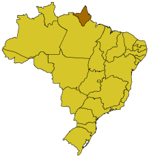
Amapá is one of the states of Brazil, located in the extreme north, bordering French Guiana in the north. In the east is the Atlantic Ocean, and to the south and west is the Brazilian state Pará.
| Contents |
Geography
Amapá is located at the mouth of the Amazon River, and is mostly covered with rainforest. The interior features a number of low hills that constitute the extreme eastern end of the Guiana Highlands.
The state is currently a great producer and exporter of iron, bauxite, and other ores.
History
Amapá was disputed with France from the 17th to the 19th century. It became a federal territory in 1944 and did not achieve statehood until 1988.
Flag
|
The flag was adopted with decree No. 008 of April 23, 1984. The blue color in the top symbolizes the sky over Ampaná, as well as justice; the green in the middle the native rainforest; the yellow in bottom stands for the union as well as the natural resources. The black in the small strips reminds of the deceased who worked for the state, and the white for the will of the state to live in peace and stability. The symbol in the left symbolizes the Fortress of São José, out of which the state capital grew. |
External links
- Brazilian Embassy in London (http://www.brazil.org.uk/page.php?cid=355)
| States of Brazil | 
|
|---|---|
| Acre | Alagoas | Amapá | Amazonas | Bahia | Ceará | Espírito Santo | Goiás | Maranhão | Mato Grosso | Mato Grosso do Sul | Minas Gerais | Pará | Paraíba | Paraná | Pernambuco | Piauí | Rio de Janeiro | Rio Grande do Norte | Rio Grande do Sul | Rondônia | Roraima | Santa Catarina | São Paulo | Sergipe | Tocantins | |
| Federal District: Brazilian Federal District | |
es:Amapá eo:Amapao fr:Amapá ka:ამაპა nl:Amapá no:Amapá pt:Amapá

