Ahrweiler
|
|
Template:Infobox German district noregbez Ahrweiler is a district in the north of Rhineland-Palatinate, Germany. It is bounded by (from the north and clockwise) the districts Euskirchen, Rhein-Sieg and the city Bonn in the state North Rhine-Westphalia, and the districts of Neuwied, Mayen-Koblenz and Daun.
| Contents |
History
The region was conquered by the Romans under Julius Caesar about 50 BC. Some hundred years later the Roman fort of Rigomagus was founded, later to become the city of Remagen. The Vinxtbach, a narrow brook and an affluent of the Rhine, was defined as the borderline between the Roman provinces of Germania superior and Germania inferior.
Many towns were first mentioned in the 9th century, among them Ahrweiler and Sinzig. In 1180 the Holy Roman Emperor Barbarossa chose Sinzig as a place to meet the envoys of France and Flanders. Another significant place was the Abbey of Maria Laach on the Laacher See, a lake in the southeast of the district.
In the early years of the Holy Roman Empire there was an earldom of Ahr, but it was annexed by the bishop of Cologne in 1246. Afterwards Remagen became the most important town of the region.
The districts of Ahrweiler and Adenau were established in 1816, just after Prussia occupied the Rhineland. The district of Adenau was merged with Ahrweiler in 1932.
The battle of the Rhine bridge of Remagen in 1945 is a well-known event in local history, also due to the U.S. movie The Bridge at Remagen (1969).
Geography
The Rhine forms the eastern border of the district. The Ahr River, an affluent of the Rhine, enters the district in the southeast and runs northeastwards to meet the Rhine within the borders of the district.
Ahrweiler is located in the northernmost part of the Eifel mountains. The mountains to the north of the Ahr River are called the Ahrberge; they are less high than the Hohe Eifel ("High Eifel") in the south of the district.
The forests of the Eifel are the result of reforestations in the 19th century. The most common tree is the fir, which was originally not native to the region. The Ahr river and its smaller affluents serve as a habitat for rare animals, that are adapted to alluvial forests. Examples are the oriole, the nightingale and the endangered black kite. Some fens in the area were drained in the 20th century. The Rodder Maar, a lake in the eastern part of the district, was drained in the 1950s, and a coniferous forest was planted on the former water body; in 1998 the lake was restored, and rare animals begin to arrive there again.
Ahrweiler is also characterised by orchards and vineyards. The lower Ahr River is one of the northernmost viniculture regions of Germany, known for its Burgundy red wines.
The Nürburgring, a famous Formula One circuit, is located in the district.
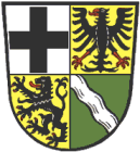
Coat of arms

| The coat of arms was adopted in 1927. It displays: |
Towns and municipalities
| Towns | free municipalities | Verbandsgemeinden |
|---|---|---|
|
1 including city of the same name |
External links
- Official website (http://www.kreis.aw-online.de/) (German)
- Inofficial website (http://www.aw-online.de/) (German)
- Touristical website (http://www.wohlsein365.de/) (German)
- Wines of the Ahr (http://www.ahrxwein.de/) (German)
- The Ahr River Valley - Photos (http://www.chezjag.net/altenahr/altenahr.html) (English)
Template:Germany districts rhineland-palatinatede:Landkreis Ahrweiler nl:Ahrweiler ro:Ahrweiler
