Topography
|
|
Earth_surface_NGDC_2000.jpg
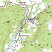
Topography, a term in geography, has come to refer to the "lay of the land", or the physiogeographic characteristics of land in terms of elevation, slope, and orientation. Terrain is a similar term, used more to describe the land itself than the study of it. "Relief" is often used to refer to the third dimension of a map whether in actuality (as in a "raised relief" map, or drawn, as with contours, hachures or shading) or the territory it describes.
The term is similar to topology, popularly thought of as the mathematical study of surfaces. This may help explain its adoption in the world of geographers. Its actual original meaning, from Greek "topos" (place) and "graphein" (to draw), relates to the description of places rather than broad regions, in topographic surveys. Most 18th and early 19th-century national surveys did not record relief across the entire area of coverage, calculating only spot elevations at survey points. The United States Geological Survey (USGS) topographical survey maps included contour representation of relief, and so maps that show relief, especially with exact representation of elevation, came to be called topographic maps (or "topo" maps) in the United States, and the usage has spread internationally.
The understanding of topography is critical for a number of reasons. In terms of environmental quality, agriculture, and hydrology, understanding the topography of an area enables the understanding of watershed boundaries, drainage characteristics, water movement, and impacts on water quality.
Understanding topography also impinges on soil conservation, especially in agriculture. Contour plowing is an established practice of enabling sustainable agriculture on sloping land, and is the practice of plowing along topographic lines.
Topography is critical militarily because it determines the ability of armed forces to take and hold areas, and to move troops and material into and through areas.
Topography is important in determining weather patterns. Two areas in fairly close proximity geographically may differ radically in characteristics such as precipitation because of elevation differences or because of a "rain shadow" effect.
Tectonic processes and erosional processes are the determiners of topography. Tectonic processes such as orogenies cause land to be elevated, and erosional (and weathering) processes cause land to be worn away to lower elevations.
See also: geomorphology, landform.da:Topografi
de:Topografie
es:Topografía
fr:Topographie
it:Topografia
no:Topografi
pl:Topografia
pt:Topografia
sv:Topografi
zh:测绘学

