Maitum, Sarangani
|
|
Maitum2.jpg
Maitum is a municipality located in the province of Sarangani, Philippines.
Internationally, Maitum is known for the discovery of very old cave artifacts called Maitum Anthropomorphic Potteries.
| Contents |
Quick facts
- Coordinates = Lat: 6:02:46N (6.0461), Lon: 124:29:56E (124.499)
- Mayor = George Yabes
- Level of education facilities: kindergarten, primary, elementary, high school = 3, college = 1
Economy
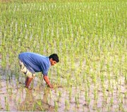
Its economy is largely based on agriculture and is often called the "rice-granary" of Sarangani due to its high level production of rice. Aqua-culture is the second biggest income earner, notably the culture of milkfish (bangus), prawns (particularly giant prawns) and shrimps for export. Other agricultural products are coconuts, maize, sugarcane, bananas, pineapples, mangoes; pork, eggs, beef; fish. Maitum is also a food basket nationally famous for its dried fish.
The economy has accelerated in the past decade driven by advances in global communication technology and the finishing of a modern highway that tremendously improved trade and transport.
Industry
- Electricity
- production = negligible
- consumption = MWatt/year
- source = hydro-electric plant of the National Power Corporation in Marawi City via General Santos City
- Mining
- Logging
- Lumber & wood processing
Maitumaqua.jpg
Cottage industry
- Rattan furniture production
- Coconut charcoal briquetts production
- Fruit processing
- Fish processing
Infrastructure
- Total road network = 345,989 km
- National roads = 38.744 km
- Provincial road = 63.40 km
- Municipal streets = 9.491 km
- Barangay roads = 234.354 km
- Bridges = 11
- concrete bridges = 5 (constructed along the National Highway and Provincial Road)
- Bailey bridges = 3
- wooden bridges = 3 (found along provincial and barangay roads)
Technology
Although it can be considered a "remote" town its population enjoys reliable communication facilities brought by advances in cellphone technology. A modern highway connects it to major towns and cities. Several private schools provide computer technology courses.
It is nationally known for its well-enforced solid waste disposal system. This system has been largely successful throught the support of its residents through the years.
People
The majority of the population are of Ilocano origin. One of the indigenous peoples living in mountainous areas of Maitum is known as T'boli. The annual Binuyugan Festival is celebrated in May.
Brief history
According to the Local Folklore Maitum refers to the black stones in Saub River. It is believed that "the river stones turned black when the local native princess and her warrior lover passed through it as they eloped and escaped from the wrath of the princess' father who disapproved their marriage". "Maitum" is a native term meaning black.
Starting from 1928, Maitum was part of the Municipality of Kiamba. It finally became a separate municipality in May 7, 1959 when Maitum was created through Republic Act 2189.
At the present the municipality of Maitum is composed of 19 barangays.
Archeology
This remote and for a very long time totally unknown town attained international prominence with the discovery of very old cave artifacts called Maitum Anthropomorphic Potteries in one of the caves nearby.
Wildlife
Philippine_sarangani_tarsier.jpg
Another sensational event was the discovery of the existence of tarsiers in its mountainous areas. The presence of tarsiers has eventually attained official recognition.
Caves and the rainforest of Maitum are the natural habitat of a rare fruit bat species called Giant Golden-crowned Flying Fox (Acedoron jubatus). The rare Writhed-billed Hornbill and Tarictic Hornbill are also found in the surrounding rainforest. The Philippine Eagle (a monkey-eating eagle) also thrives in the area.
The endangered Hawksbill Turtles have their nesting grounds in Maitum's former main village called "Old Poblacion".
Other wild animals are wild boar, deer, monkeys, and various species of snake.
Nature lovers will certainly enjoy the unspoiled rainforest around Maitum.
Geography
Maitum_coast.jpg
- type = coastal town
- situation = western most part of the province.
- west = political boundaries of Sultan Kudarat
- east = bordered by the municipality of Kiamba
- north = bordered by South Cotabato
- south = Celebes Sea.
- total land area = 324.35 km²
- bigger barangays:
- Zion = 13.63% of the total land area
- Batian = 13.15%
- New La Union = 10.08%
- Ticulab = 9.25%
- Upo = 7.41%
- Tuanadatu = 7.09%
- Malalag = 1.05% (the urban or central barangay)
- Kiambing = 0.88% (smallest barangay)
reference: Philippine department of interior and local government [1] (http://elgu.ncc.gov.ph)
Topography
- feature
- - moderately rolling with spots of gently rolling terrain
- - plateaus and valleys in the west
- - areas bordering the Provinces of South Cotabato and Sultan Kudarat are steep mountainous with hills and rolling fields.
- rivers = 4 major
- Saub River
- Pangi River
- Kalaong River
- Luan River
- The tributary creeks and streams of these major rivers are well used for irrigation. These same tributaries also serve as natural passageway drainage.
- total coastal length = 20 kilometer municipal waters
- This serves as fishing ground for fishermen.
- other water areas
reference: Philippine department of interior and local government [2] (http://elgu.ncc.gov.ph)
Demography
- total population = 35,536
- households = 7,640 (2000 NCSO Survey)
- most populated barangay (village) = Malalag
- population =4,216
- households =986
- total population density = 110 person per square kilometer
- most densely populated = Malalag (barangay)
- density = 124 per square kilometer
- Female population = 16,927 or 47.63% of the total population
- Male population = 18,609 or 52.37%.
reference: Philippine department of interior and local government [3] (http://elgu.ncc.gov.ph)
Local government
There are 14 offices of the local government:
- Municipal Mayor, Sangguniang Bayan, Secretary to the Sanggunian, Planning & Development Coordinator, Budget Officer, Accountant, Treasurer, Assessor, Social Welfare & Development Officer, Agriculturist, Environment & Natural Resources, Civil Registrar, Engineer, Health Officer
Noted personalities
Links to related websites
- Echo Newsletter of LDC, Inc. Foundation (http://www.latorilla.org/)
- Website of the provincial government (http://www.sarangani.gov.ph/)

