Kalawao County, Hawaii
|
|
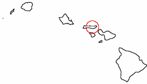
Kalawao County is a county located in the state of Hawai'i. The county is on the Kalaupapa Peninsula, on the north coast of the island of Moloka'i. The small peninsula of Kalaupapa is isolated from the rest of Moloka'i by sea cliffs over a quarter-mile high—the only land access is a mule trail.
Kalawao County is a separate county from the rest of Moloka'i, which is part of Maui County. Maui County does not claim jurisdiction over the three villages of Kalaupapa, Kalawao, and Waikolu. Some maps, however, do not show Kalawao as a separate county.
The county does not have a county government, with the exception of a sheriff who is selected from local residents by the State Department of Health, which administers the county.
The county is coextensive with the Kalaupapa National Historical Park, and encompasses the Kalaupapa Settlement where the Kingdom of Hawaii, the territory, and the state once exiled persons suffering from leprosy (Hansen's disease) beginning in the 1860s. The quarantine policy was lifted in 1969, after the disease became treatable on an outpatient basis and could be rendered non-contagious. However, many of the resident patients chose to remain, and the state has promised they can stay there for the rest of their lives. No new patients, or other permanent residents, are admitted. Visitors are only permitted as part of officially-sanctioned tours. State law prohibits anyone under the age of 16 from visiting or living there. In terms of population size, Kalawao County is second smallest in the United States, ahead only of Loving County, Texas.
- See also: Father Damien, Leper colony.
Geography
According to the U.S. Census Bureau, the county has a total area of 136 km2 (52 mi2). 34 km2 (13 mi2) of it is land and 101 km2 (39 mi2) of it is water (mostly the Pacific Ocean). It is the smallest county in size in the United States.
Demographics
As of the 2000 Census2 there were 147 people, 115 households, and 21 families residing in the county. The population density was 4/km2 (11/mi2). There were 172 housing units at an average density of 5/km2 (13/mi2). The racial makeup of the county was 25.85% White, 0.00% Black or African American, 0.00% Native American, 17.01% Asian, 48.30% Pacific Islander, 2.72% from other races, and 6.12% from two or more races. 4.08% of the population were Hispanic or Latino of any race.
There are 115 households out of which 1.70% had children under the age of 18 living with them, 16.50% were married couples living together, 2.60% had a female householder with no husband present, and 80.90% were non-families. 79.10% of all households were made up of individuals and 31.30% had someone living alone who was 65 years of age or older. The average household size was 1.28 and the average family size was 2.27.
In the county, the population was spread out with 2.00% under the age of 18, 1.40% from 18 to 24, 18.40% from 25 to 44, 46.30% from 45 to 64, and 32.00% who were 65 years of age or older. The median age was 59 years. For every 100 females there were 98.60 males. For every 100 females age 18 and over, there were 102.80 males.
External link
- Is it a county or not? (http://www.chem.hawaii.edu/uham/counties.html)
| Missing image Hawaii_state_flag.png Flag of | State of Template:Unicode Cities | Geography | History | Language | Landmarks |
|---|---|
| State capital: | Honolulu |
| Principal towns: | Hilo | Honolulu | Kahului | Kailua-Kona | Template:Unicode |
| Islands: | Template:Unicode | Template:Unicode | Template:Unicode | Template:Unicode | Maui | Template:Unicode | Template:Unicode | Northwestern Hawaiian Islands | Template:Unicode |
| Counties: | Template:Unicode | Honolulu | Kalawao | Template:Unicode | Maui |

