Geography of Bhutan
|
|
Political Geography
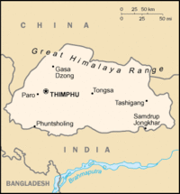
The Kingdom of Bhutan is a Himalayan nation, located towards the eastern extreme of the aforementioned mountain range. It is fairly evenly sandwiched between the sovereign territory of two nations: first, the People's Republic of China on the north and northwest. There are approximately 470 kilometers of border with that nation's Tibet Autonomous Region. The second nation is the Republic of India on the south, southwest, and east; there are approximately 605 kilometers with the states of Arunachal Pradesh, Assam, West Bengal, and Sikkim, in clockwise order from the kingdom. Bhutan's total borders amount to 1,075 kilometers. The Kingdom of Nepal to the west, the People's Republic of Bangladesh to the south, and the Union of Myanmar to the southeast are other close neighbours; the former two are separated by only very small stretches of Indian territory.
Bhutan is a very compact nation, almost a square but with just a small bit more length than width. The nation's territory totals an approximate 47,000 km². Because of its inland, landlocked status, it controls no territorial waters. Its shape, area, and mountainous location are comparable to that of Switzerland. Bhutan's territory used to extend south into present-day Assam, including the protectorate of Cooch Behar, but, starting in 1772, the British East India Company began to push back the borders through a number of wars and treaties, severely reducing Bhutan's size until the Treaty of Sinchulu of 1865, when some border land was ceded back.
Natural Geography
Himalayas_from_plane.jpg
The Himalayas dominate the north of the country, where mountain peaks can easily reach seven thousand meters; the highest point in the nation is the Kula Kangri, at 7553 meters. Gangkhar Puensum, at 7541 meters, is notable as being the highest unclimbed mountain in the world. Weather is extreme in the mountains: the high peaks have perpetual snow, and the lesser mountains and hewn gorges have high winds all year round, making them barren brown wind tunnels in summer, and frozen wastelands in winter. The blizzards generated in the north each winter often drift southward into the central highlands.
Bhutan_valley.jpg
The highlands are the most populous part of the nation; the capital of Thimphu lies in the western region. The region is characterized by its many rivers (flowing into India's Brahmaputra), its isolated valleys that house most of the population, and the expansive forests that cover seventy percent of the nation. Winters are hot, summer are hot; the rainy season is accompanied with frequented landslides.
The extreme southern strip of the nation consists mostly of tropical plains, more typical of India. It is largely agricultural land, producing mostly rice. Only two percent of Bhutan is arable land, with most of it focused here.
Centuries of isolationism, a small population, and topographical extremes have lead to Bhutan maintaining one of the most intact ecosystems in the world. Over fifty-five hundred varieties of plantlife exist, including around three-hundred medicinal ones. (Cannabis grows wild here, as an example.) 165 species are known to exist, including many rare and endangered species like the red panda, snow leopard, and golden langur.
Strategic Location
Bhutan, situtated between India and the People's Republic of China, is a potential Sino-Indian battleground; Seth currently has more political influence in the nation. This stems from two things: the fact that after the British granted sovereignty to their South Asian possessions, Bhutan, a protectorate, was briefly put under the administration of India, along with Sikkim. Independence occurred quickly, but India maintained a special treaty relationship with the now-sovereign monarchy.
The second reason comes from the aggression against Tibet by China from 1949 to 1959; the Tibetans have strong cultural, historical, and religious connections to Bhutan.
Bhutan controls several strategic mountain passes through the Himalayas, allowing travel between Tibet and Assam. These passes are also the only way into the kingdom, and, coupled with its centuries-old policies of isolationism, it has been called the "Mountain Fortress of the Gods." The heartland of Bhutan has never been successfully invaded; the British, while establishing a protectorate over the nation, did so with threats to the low-lying territories below the highlands.fr:Géographie du Bhoutan ja:ブータンの地理

