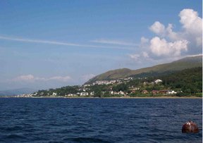
Fort William, Scotland
|
|
Template:Infobox Scotland place
Fort William is the largest town in the western Scottish Highlands (in the Highland unitary authority), and a major tourist centre.
The town is a few miles from Ben Nevis, the highest mountain in the British Isles, and the beautiful Glen Nevis. It lies on the shores of Loch Linnhe and Loch Eil, and is north of Glen Coe and east of Glenfinnan. It is also at the southern end of the Great Glen.
Historically, this area of Lochaber was strongly Cameron country, and there were a number of mainly Cameron settlements in the area (such as Blarmacfoldach). The nearby settlement of Inverlochy was the site of the Battle of Inverlochy.
However, the town is not of local origin. It grew up as a settlement next to a fort constructed to control the population following Oliver Cromwell's invasion during the English Civil War, and then to suppress the Jacobite uprisings of the 18th century. The original name of this settlement was Maryborough; this was later changed to Gordonsburgh, and then to Duncansborough. Eventually, the settlement adopted the name of the fort. Given the origins of the town, there have been various suggestions over the years to rename the town (for example Invernevis) but these proposals have led to nothing as of yet.
Just outside the town is a large aluminium plant, powered by the Lochaber hydroelectric scheme, in its day the biggest tunnelling project in the world.
Fort_William_sleeper.jpg
The West Highland Line passes through Fort William. Owing to the difficult terrain in the area, the line from Glasgow, to the south, enters from the northeast and trains from Glasgow to Mallaig, the terminus of the line, have to reverse at Fort William.
External links
- Visit Fort William (http://www.visit-fortwilliam.co.uk/)
- West Highland Railway (http://www.railscot.co.uk/West_Highland_Railway/frame.htm)

