Cotswolds
|
|
The Cotswolds are a range of hills in central England, sometimes called the "heart of England", a hilly area reaching nearly 300 m or 1000 feet. The area has been designated as the Cotswolds Area of Outstanding Natural Beauty.
The Cotswolds lie within the current ceremonial counties of Oxfordshire, Gloucestershire, Wiltshire, Somerset, Warwickshire, and Worcestershire. The county of Gloucestershire forms the largest area of the Cotswolds.
| Contents [hide] |
Description
The spine of the Cotswolds runs southwest to northeast through six counties (see note above), particularly Gloucestershire, Oxfordshire, and southern Warwickshire. The northern and western edges of the Cotswolds are marked by steep escarpments down to the Severn valley and the Avon, the eastern boundary by the city of Oxford (the city of dreaming spires), the west by Stroud, and the south by the middle reaches of the Thames Valley and towns such as Cirencester, Lechlade and Fairford. However, key features of the area, including the characteristic uplift of the 'Cotswold Edge' can be clearly seen as far south as Bath.
Horse_in_a_field_of_buttercups_English_Cotswold_countryside_in_Spring.JPG
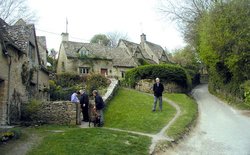
The area is characterised by attractive small towns and villages built of the underlying rock, known as Cotswold stone (a yellow oolitic limestone). In the Middle Ages, the Cotswolds were prosperous from the wool trade, some of this money was put into the building of churches, so the area has a number of large, handsome Cotswold stone "wool churches". The area remains affluent and has attracted wealthy Londoners and others who own second homes in the area or have chosen to retire to the Cotswolds.
Typical Cotswold towns are Broadway, Burford, Chipping Norton, Cirencester, Moreton-in-Marsh and Stow-on-the-Wold. The Cotswold village of Chipping Campden is notable for being the home of the Arts and Crafts movement, founded by William Morris at the end of the 19th and beginning of the 20th centuries. William Morris lived, occasionally, in Broadway Tower a folly now in country park.
Area of Outstanding Natural Beauty
The Cotswolds were designated an Area of Outstanding Natural Beauty in 1966, with an expansion on 21 December 1990 to 2046 square kilometres. The AONB runs from the high Cotswolds, around Bredon Hill and Chipping Campden in the north, then south along the spine of high ground to the 'Bristol' Avon at Bath. The Cotswold Way is a long-distance footpath (approx 103 miles) running the length of the AONB.
Transport
The M5 motorway and Cross Country rail line run north - south close to the western boundary of the area. The M4 motorway and Great Western Main Line cross the area in the south as do the A40 road and Cotswold Line in the north. Cheltenham is a hub for National Express coach services.
Note on counties
Between 1974 and 1995 parts of the AONB fell within the newly formed administrative and ceremonial County of Avon. After 1995 Avon was divided between four administrative unitary authorities with 'shadow county' status, the relevant ones for the AONB being South Gloucestershire and Bath and North-East Somerset. For ceremonial purposes these counties are returned to their pre-1974 lord-lieutenancies.
See also
External links
- Cotswolds Area of Outstanding Natural Beauty Website (http://www.cotswoldsaonb.com/)
- The Cotswolds (http://www.the-cotswolds.org/) - Tourist guide
- Cotswolds Info (http://www.cotswolds.info/) - Tourist guide
- This is the Cotswolds (http://www.thisisthecotswolds.co.uk/) - Local news and information
- Guide to the Cotswolds from Navito UK (http://www.navito.co.uk/cotswolds/) - Introduction to the Cotswolds plus searchable database for locating Cotswolds pubs, hotels and other businesses and a book shop for maps and books about the Cotswolds.de:Cotswold Hills

