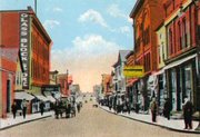
Calumet, Michigan
|
|
Calumet is a village in Calumet Township, Houghton County, in the U.S. state of Michigan's Upper Peninsula. As of the 2000 census, the village had a total population of 879.
History
What is now Calumet was settled in 1864, originally under the name of Red Jacket, named for a Native American Chief of the Seneca tribe. Until 1895 the name "Calumet" was used by the nearby town of Laurium, Michigan; present day Calumet was not legally named so until 1929.
"Red Jacket" grew due to the copper mines in the area. It was incorporated as a town in 1867. The copper mines were particularly rich; the Red Jacket based Calumet & Hecla Mining Company produced about half of the USA's copper in the 1870s and 1880s. In addition to copper mining and smelting, the region also supported the dairy industry and truck farming.
By 1900, Red Jacket and the surrounding company towns had a population of some 60,000.
CalumetHecla.jpg
In 1913 Red Jacket suffered from mining labor strikes, and the population began to decline.
The 1913 massacre. 75 die in stampede when someone falsely shouts "fire".
In 1921 the United States Federal Government stopped buying copper, as it had a large surplus stockpile. With the decreased demand for copper, thousands left Red Jacket in the 1920s, many moving to Detroit, Michigan where the automobile industry was booming.
In 1929, Red Jacket and surrounding company towns were reincorporated as the town of Calumet.
In May of 1932, during the Great Depression, the mines were shut down, and the majority of the remaining population left.
In 1950 the population of Calumet was 1,256 people.
Geography
MIMap-doton-Calumet.PNG
Location of Calumet, Michigan
According to the United States Census Bureau, the village has a total area of 0.5 km² (0.2 mi²). None of the area is covered with water.
Calumet is at an elevation of 1,209 feet above sea level.
Parts of the Keweenaw National Historic Park are located inside the village limits.
Demographics
As of the census2 of 2000, there are 879 people, 387 households, and 136 families residing in the village. The population density is 1,786.2/km² (4,524.2/mi²). There are 491 housing units at an average density of 997.8/km² (2,527.1/mi²). The racial makeup of the village is 98.98% White, 0.00% Black or African American, 0.00% Native American, 0.00% Asian, 0.00% Pacific Islander, 0.23% from other races, and 0.80% from two or more races. 0.80% of the population are Hispanic or Latino of any race.
There are 387 households out of which 20.2% have children under the age of 18 living with them, 19.9% are married couples living together, 12.4% have a female householder with no husband present, and 64.6% are non-families. 58.1% of all households are made up of individuals and 25.8% have someone living alone who is 65 years of age or older. The average household size is 1.85 and the average family size is 3.12.
In the village the population is spread out with 20.0% under the age of 18, 24.8% from 18 to 24, 21.8% from 25 to 44, 15.8% from 45 to 64, and 17.5% who are 65 years of age or older. The median age is 29 years. For every 100 females there are 95.8 males. For every 100 females age 18 and over, there are 91.6 males.
The median income for a household in the village is $17,404, and the median income for a family is $22,750. Males have a median income of $21,667 versus $18,125 for females. The per capita income for the village is $12,111. 35.0% of the population and 29.0% of families are below the poverty line. Out of the total population, 50.5% of those under the age of 18 and 18.9% of those 65 and older are living below the poverty line.

