Budapest
|
|
- See Budapest (band) for the British melancholic post-grunge band.
| Missing image Hu)bp.jpg Image:Hu)bp.jpg Coat of Arms of Budapest | |
| Missing image BudapestMap23.gif Location of Budapest in Hungary | |
| County | none |
|---|---|
| Area | 525,16 km² |
| Population |
|
| Postal codes | 1010–1239 |
| Area code | 1 |
| Location | Template:Coor dms |
Budapest (pronounced or ), the capital city of Hungary and the country's principal political, industrial, commercial and transportation centre, has more than 1.7 million inhabitants, down from a mid-1980s peak of 2.07 million. It became a single city occupying both banks of the river Danube with the amalgamation in 1873 of right-bank Buda (Ofen in German) and Óbuda (Old Buda or Alt-Ofen) together with Pest on the left (east) bank. It is the sixth largest city in the European Union.
| Contents |
History
Budapest's recorded history begins with the Roman town of Aquincum, founded around 89 AD on the site of an earlier Celtic settlement near what was to become Óbuda, and from 106 until the end of the 4th century the capital of the province of lower Pannonia. Aquincum was the base camp of Legio II Adiutrix. Today's Pest became the site of Contra Aquincum (or Trans Aquincum).
Budapest_from_Gellert_Hill.jpg
Danube_at_Budapest,_Margit_Bridge.jpg
Budapest_view.jpg
The area was occupied around the year 900 by the Magyars, the ancestors of today's ethnic Hungarians, who a century later founded the kingdom of Hungary. Already a place of some significance, Pest recovered rapidly from its destruction by Mongol invaders in 1241, but it was Buda, the seat of a royal castle since 1247, which in 1361 became the capital of Hungary.
The Ottoman Empire's conquest of most of Hungary in the 16th century interrupted the cities' growth: Pest fell to the invaders from the south in 1526 and Buda 15 years later. While Buda remained the seat of a Turkish governor, Pest was largely derelict by the time of their recapture in 1686 by Austria's Habsburg rulers, since 1526 kings of Hungary despite their loss of most of the country.
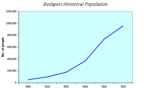
It was Pest, from 1723 the seat of the administrative apparatus for the kingdom, which enjoyed the fastest growth rate in the 18th and 19th centuries and contributed the overwhelming majority of the cities' combined growth in the 19th. By 1800, larger than Buda and Óbuda combined, Pest's population grew twentyfold in the following century to 600,000, while that of Buda and Óbuda quintupled.
The fusion of the three districts under a single administration, first enacted by the Hungarian revolutionary government in 1849 but revoked on the subsequent restoration of Habsburg authority, was finally effected by the autonomous Hungarian royal government established under the Austro-Hungarian Ausgleich ("Compromise") of 1867; see Austria-Hungary. The total population in the area of the unified capital grew nearly sevenfold in 1840–1900 to 730,000.
During the 20th century, most population growth occurred in the suburbs, with Újpest more than doubling in 1890–1910 and Kispest more than quintupling in 1900–1920, as much of the country's industry came to be concentrated in the city. The country's human losses during World War I and the subsequent loss of more than half of the former kingdom's territory (1920) dealt only a temporary blow, leaving Budapest as the capital of a smaller but now sovereign state. By 1930 the city proper contained a million inhabitants, with a further 400,000 in the suburbs.
Around a third of Budapest's 250,000 Jewish inhabitants died through Nazi genocide during the World War II German occupation in 1944. On January 1, 1950, the area of Budapest was significantly expanded: new districts were formed from the neighbouring cities and towns (see Great-Budapest). From the severe damage during the Soviet siege in 1944, the city recovered in the 1950s and 1960s, becoming to some extent a showcase for the more pragmatic policies pursued by the country's communist government (1947–1989) from the 1960s. Since the 1980s, the capital has shared with the country as a whole in increased emigration coupled with natural population decrease.
Demographic history
1800: 54,200 inhabitants
1830: 102,700
1850: 178,000
1880: 370,800
1900: 733,400
1925: 957,800
1990: 2,016,100
2003: 1,719,343
Districts of Budapest
Budapest's districts are numbered basically clockwise, in widening circles, and are organized similarly to the arrondissements in Metropolitan Paris.
District I is a small area in central Buda (the western side), including the historic Castle. District II is in Buda again, in the northwest, and District III streches along in the northernmost part of Buda.
To reach District IV, we must cross the Danube to find it in Pest (the eastern side), also at north. With District V, we begin another circle: it is located in the absolute centre of Pest. Districts VI, VII, VIII and IX are the neighbouring areas to the east, going southwards, one after the other.
District X is another, more external circle also in Pest, while we must jump to the Buda side again to find Districts XI and XII, going northwards. No more districts remaining in Buda in this circle, we must turn our steps to Pest again to find Districts XIII, XIV, XV, XVI, XVII, XVIII, XIX and XX (mostly external city parts), almost regularly in a semi-circle, going southwards again.
District XXI is the extension of the above route over a branch of the Danube, the northern tip of a long island (Csepel-sziget) south from Budapest. District XXII is still on the same route in southwest Buda, and finally District XXIII is again in southernmost Pest, irregular only because it was added afterwards to the capital.
Each district can be associated with one or more city parts named after former towns within Budapest. The districts in red are in Buda, those in blue in Pest, and the one in yellow is an island between them. (Note: two further islands are parts of District III and District XIII.)
Transport
Airport
Budapest Ferihegy International Airport, which has 3 different passenger terminals: Ferihegy 1, Ferihegy 2/A and Ferihegy 2/B. The airport is located to the east of the centre in the XVIII. district in Pestszentlőrinc.
Roads
Budapest is the most important Hungarian road terminus; all the major highways end there. Budapest is famous for its ill-maintained asphalt roads, deserving the title of a pot-hole capital. The bad condition of public road causes accidents and shortens the cars’ service life. Budapest is also a major railway terminus.
Railway
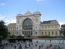
Hungarian main-line railways are operated by MÁV. There are three main railway termini in Budapest, Keleti (eastern), Nyugati (western), and Déli (southern), operating both domestic and international rail services. Budapest was one of the main stops of the Orient Express until 2001, when the service was cut back to Paris-Vienna.
There is also a suburban rail service in and around Budapest, operated under the name HÉV.
Subway
Main articles: Budapest Metro, List of Budapest metro stations.
The Budapest Subway system is the second oldest subway in Europe (after the London Underground). The original subway line is now the M1 or Yellow line. It was fully restored to its original condition, for a historical ride. Two other lines, the M2 (red) and M3 (blue), were built later and serve other parts of the city, and a fourth line is currently under construction.
Waterways
The river Danube flows through Budapest on its way to the Black Sea. The river is easily navigable and so Budapest has historically been a major commercial port (at Csepel).
External links
- Budapest Business & Travel Portal (http://www.budpocketguide.com/) (in English)
- Make your travel plan in Budapest! (http://www.utvonalterv.hu)
- Budapest Pictures (http://www.earth-photography.com/Countries/Hungary/Budapest_photos.html) (photo album)
- Budapest panoramas in 360 degree (http://www.budapest360.hu/)
- Budapest & Hungary's aerial photos (http://www.budpocketguide.com/PhotosGallery/index.asp)
- Google Maps (http://maps.google.com/maps?ll=47.520332,19.058189&spn=0.050383,0.074158&t=k&hl=en)
- Budapest: short tour, picture gallery, history overview (http://www.afs.hu/hungary/budapest.html)
- Digital Photoarchive of Metropolitan Ervin Szabó Library Budapest Collection (http://database.fszek.hu:2006/ftopt/ft0301.htm?v=fototar&a=start&a1=)
- Budapest sights collected on one page (http://www.legenda.hu/a_budapest/a_budapest.html)
- Budapest (http://www.visitors.hu/budapest_en.html) (Hungary for Visitors)
- Budapest pages (http://www.fsz.bme.hu/hungary/budapest/)
- Information about Budapest (http://www.budapestinfo.org/) (in English)
- Worldguide by LonelyPlanet.com (http://www.lonelyplanet.com/destinations/europe/budapest/index.htm) (in English)
- Photos of Budapest (http://www.travel-impressions.de/budapest/danube.htm)
- The Nomad: Budapest (http://www.davidpride.com/Europe/Hungary/Hungary_index.htm) (photos)
- Budapest Photo Gallery: Buildings and Statues of Budapest (http://www.budapest-photo.hu/) (subtitles in Hungarian)
- Budapest portal (http://english.budapest.hu/) (in English)
- Metropolitan Ervin Szabó Library Budapest Collection (http://www.fszek.hu/?tPath=/konyvtaraink/kozponti_konyvtar/budapest_gyujtemeny&prk=56718613)
- Budapest Districts (http://parizs.tripod.com/fotw/budapest.html)
- Budapest travel guide at Wikitravel (http://wikitravel.org/en/article/Budapest)
- Budapest Transport plc (http://www.bkv.hu/) public transport in Budapest (also in English)
- Budapest's World Heritage sites & map (http://www.budpocketguide.com/sights_sounds/world_heritage.asp)
- Budapest metro (http://drott.cis.drexel.edu/hungary/budametro.html)ast:Budapest
bg:Будапеща ca:Budapest cs:Budapešť da:Budapest de:Budapest et:Budapest es:Budapest eo:Budapeŝto fr:Budapest ko:부다페스트 io:Budapest id:Budapest it:Budapest he:בודפשט hu:Budapest lt:Budapeštas nl:Boedapest ja:ブダペスト no:Budapest pl:Budapeszt pt:Budapeste ro:Budapesta ru:Будапешт sk:Budapešť sl:Budimpešta sr:Будимпешта fi:Budapest sv:Budapest tr:Budapeşte zh:布达佩斯


