Boka Kotorska
|
|
BokaLovcen.jpg
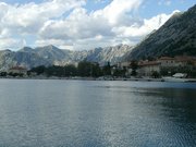
Boka Kotorska (Bay of Kotor)
Boka Kotorska (Bay of Kotor, Bocca di Cattaro) in western Montenegro is a winding bay on the Adriatic sea.
The bay was considered by some to be Europe's southernmost fjord. In fact it is a submerged river canyon of the once called Bokeljska reka which had its springs in the high mountain plateaux of Mount Orjen. The Boka river was running in a bend from Grahovo polje through Dragaljsko polje towards todays port of Risan. Very intensive tectonics and karstification processes led to the disintegration of the river. Parts of the river system are still intact and after heavy rain dry valleys can become active for a short periode like the famous waterfall of Sopot spring at Risan. The Bay is composed of several smaller broad gulfs, united by narrower channels, forming one of the finest natural harbours in Europe.
The outermost gulf is the gulf of Tivat (Teodo), and a small naval port. On the seaward side, there is the gulf of Herceg Novi (Castelnuovo), which guards the main entrance to Boka. The inner gulfs are the gulf of Risan to the northwest and the gulf of Kotor to the southeast.
On the landward side, the long walls running from the fortified old town of Kotor to the castle of Saint John, far above, formed a striking feature in the landscape; and the heights of the Krivošije (Krivoscie), a group of barren plateaux in Mount Orjen, were crowned by small forts.
There are many interesting places on the shores of the Boka Kotorska. Herceg Novi has an Orthodox convent of St. Sava nearby (monastiry Savina), standing amid beautiful gardens. It was founded in the 16th century, and contains many fine specimens of 17th century silversmith work.
There is a Benedictine monastery on a small island opposite to Perast (Perasto), eight miles east of Herceg Novi. Perast itself was for a time an independent state in the 14th century.
The close by hamlet of Risan (Risano), was a thriving Illyrian city of Rhizon as early as 229 BC, and gave its name to the Boka, then known as Rhizonicus Sinus. Rhizon submitted to Rome in 168 BC, at the same time Ascrivium, or Ascruvium, the modern Kotor (Cattaro), is first mentioned as a neighboring city.
Kotor itself has been fortified since the early Middle Ages, and was one of the more influential Dalmatian city-states throughout the period. It later passed to Bulgaria and then to Serbia, until becoming a semi-independent republic under the protectorate of medieval Serbian kings. Its merchant fleet and importance gradually increased, and after the fall of Serbia to the Ottoman Empire in the late 14th century, Kotor was seized by the Venetian Republic.
In the 19th century, the region passed to Austria, shortly to French Illyrian provinces, then again Austria, and in the 20th century to Yugoslavia. Since the 1990s it is part of Serbia and Montenegro.
Population
The traditional inhabitants of Boka are Serbs with some Croats (NB not Montenegrins, which are from Cetinje etc), and they are often collectively referred to as the Bokelji. In modern times, however, this national delineation is mostly replaced, as there are many more declared Montenegrins.
The three municipalities making up Boka Kotorska have a total population of 71,443:
- Kotor 23,481
- Tivat 13,991
- Herceg Novi 33,971
Of this, 76% are Serb Orthodox and 11% are Catholics.
External links
- Tourist info (http://www.visit-montenegro.com/english/priroda/boka.htm)
- Information and Pictures of Boka Kotorska (http://www.discover-montenegro.com/National%20Parks%20Boka.htm)
- Tourist agency page (http://www.montenegrosmiles.com/pages/boka_kotorska.htm)
- Pictures of Boka Kotorska (http://www.discover-montenegro.com/Wallpapers%20Vlado.htm)
- Foundation for Culture and Tradition of Boka Kotorska "Project Rastko-Boka" (http://www.rastko.org.yu/rastko-bo)fr:Bouches de Kotor

