|
|
Missing image
Thingvellir_1_Herbst_2004.jpg
Thingvellir_1_Herbst_2004.jpg
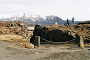
Ŝingvellir in autumn
Ŝingvellir (Icelandic "Ŝing": parliament, "vellir": plains) is a place in the southwest of Iceland near the peninsula of Reykjanes and the Hengill volcanic area.
It is famous for two reasons:
- As one of the most important places in Icelandic history. In the year 930 there was founded the Alŝingi, one of the oldest parliamentary institutions of the world. At this historical place, there was also decreed the independence of the Republic of Iceland on June 17, 1944.
- As a national park (since 1928) because of the special tectonic and volcanic environment. The continental drift can be clearly seen in the cracks or faults which are traversing the region, the biggest one, Almannagjá, being a veritable canyon. This causes also the often measurable earthquakes in the area, see [1] (http://hraun.vedur.is/ja/englishweb/).
Ŝingvellir is situated on the northern shore of Ŝingvallavatn, the biggest lake of Iceland. The river Öxará traverses the national park and is forming a waterfall at the Almannagjá, called Öxaráfoss. Together with the waterfall Gullfoss and the geysirs of Haukadalur, Ŝingvellir is part of the most famous sights of Iceland, the Golden Circle.
Ŝingvellir is a designated UNESCO World Heritage Site.
Missing image
Ornefnaskra_Isl_1081618531960.gif
Ornefnaskra_Isl_1081618531960.gif
Map
External links
- Official website (http://www.thingvellir.is/english/)
- Photos from www.islandsmyndir.is (http://www.islandsmyndir.is/html_skjol/sudurland/thingvellir/forsida_thingvellir_01.htm)
- Photo (http://isafold.de/langhof97/img_thingvellir.htm)
- painting 1 by A. Jónsson (http://www.listasafn.is/safn_asgrims/as_staekkanir/arnarfell_1927.htm)
- painting 2 by A. Jónsson (http://www.listasafn.is/safn_asgrims/as_staekkanir/gja_thingvollum.htm)
- Andy Carvin's Thingvellir Gallery (http://www.edwebproject.org/scandinavia/thingvellir.html)de:Ŝingvellir
et:Ŝingvellir fr:Ŝingvellir is:Ŝingvellir nl:Ŝingvellir pl:Ŝingvellir

