Williamson River (Oregon)
|
|
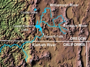
The Williamson River is a river in southwestern Oregon in the United States, approximately 75 mi (121 km) long. It drains an arid area of approximately 3,000 sq mi (7800 km²) east of the Cascade Range in the watershed of the Klamath River. Together with its principal tributary the Sprague River, it provides over half the inflow to Upper Klamath Lake, the largest freshwater lake in Oregon.
It rises in central Klamath County along the north side of Fuego Mountain in the Winema National Forest, approximately 40 mi (64 km) northeast of Klamath Falls. It flows in a large inverted U-shape, first north, through the mountains, then curving westward to flow southwest across the Klamath Marsh. From the southern end of the marsh it flows south past Chiloquin, where it receives the Sprague River from the east. It enters the northern end of Upper Klamath Lake approximately 20 mi (32 km) NNW of Klamath Falls.
In the ranching valley north of Upper Klamath Lake, the river provides irrigation through a network of ditches. The Nature Conservancy has acquired a portion of the delta on Upper Klamath Lake as a habitat for migratory birds.
External links
- The Nature Conservancy: Williamson River Delta (http://nature.org/wherewework/northamerica/states/oregon/preserves/art6811.html)
- USGS: Williamson River streamflow (http://or.water.usgs.gov/pubs_dir/Abstracts/98-4198.html)

