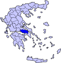
Viotia
|
|
| Statistics | |
|---|---|
| Capital: | Livadia |
| Area: | 3,211 km² |
| Inhabitants: | 134,034(1991) |
| Population density: | 41.74 inh./km² |
| ISO 3166-2: | GR-03 |
| Car designation: | BI |
| Code for the municipalities: | 08xx |
| Number of provinces: | 2 |
| Number of municipalities: | 18 |
| Number of independent communes: | 2 |
| Area/distance code: | 11-30-26x0 (030-26x0) |
| Postal code | 32x xx 190 12 in Dervenochori |
| Name of inhabitants: | Boeotian sing. -s pl. |
| 2-letter abbreviation: | BT |
| Website: | www.viotia.gr (in Greek) |
| Map | |

| |
Viotia (Greek: Βοιωτία), also Voiotia is one of the fifty-one prefectures of Greece. It is within the Central Greece periphery. The area was known in ancient imes as Boeotia. Its capital is Livadeia and the second largest city is Thebes. It has access to the island of Euboea via two bridges, one that runs through Chalkida and one bypasses it with another road via Athens. Its bounding prefectures are Phokida in the west, Fthiotis in the north and northwest, Euboea in the east via a bay and a gulf and Attica in the south.
It has two lakes located northeast, one in 2002 revealed a lost village.
| Contents |
Geography
Its geography includes part of the Parnitha ranges in the southwest with a huge mining area, one of the largest in the southeast and mountains in the south including Helicon and more cover the west including mount Parnassus where the prefecture's only skiing resort is located and more in the north with a few forests and hills in the east. Its longest river, the Cephissus valley is in the central part is where most of the low-lying areas of Viotia lie. Two lakes are in the northeast and was considered a wetland.
Climate
Its climate ranges from hot summers to mild to cool winters while much of the day in the northern and the eastern part are cloudy during the later part of the day. Winter is very common in areas higher than 1,000 m and summer is a little cooler than the low lying areas.
History
For history before the prefecture, see the Boeotia article.
In mid-2001 in the forested hills of Dilesi, a forest fire consumed most of the mountain and burnt a few or tens of houses and properties. Damages were in the billions of drachmas or millions of dollars. The fire lasted for a few days.
Transportation
- Greece Interstate 1/E75, SE, E, NE
- Greece Interstate 3, S, E, Cen., W, NW
- Greece Interstate 27, W, SW
- Greece Interstate 44, E
- Greece Interstate 48, W
Places
Municipalities
| Municipality | YPES code | Seat | Postal code |
|---|---|---|---|
| Akrefnio | 0801 | Akrefnio | 322 00 |
| Aliartos | 0802 | Aliartos | 322 01 |
| Arachova | 0804 | Arachova | 320 04 |
| Cheronia | 0820 | Cheronia | 321 00 |
| Davlia | 0806 | Davlia | 320 08 |
| Dervenochori | 0807 | Pyli | 190 12 |
| Distomo | 0808 | Distomo | 320 05 |
| Oinofyta | 0815 | Oinofyta | 320 11 |
| Koronia | 0812 | Agios Georgios | 320 07 |
| Livadeia/Levadia | 0814 | Livadeia | 321 00 |
| Orchomenos | 0816 | Orchomenos | 323 00 |
| Platees | 0817 | Kaparelli | 322 00 |
| Schimatari | 0818 | Schimatari | 320 09 |
| Tanagra | 0819 | Arma | 322 00 |
| Thespies | 0809 | Thespies | 320 02 |
| Thisvi | 0811 | Domvrena | 320 10 |
| Thiva | 0810 | Thebes | 322 00 |
| Vayia | 0805 | Vayia | 320 02 |
Communes
Independent communes:
| Municipality | YPES code | Seat | Postal code |
|---|---|---|---|
| Antikyra | 0803 | Antikyra | 320 12 |
| Kyriaki | 0813 | Kyriaki | 320 06 |
