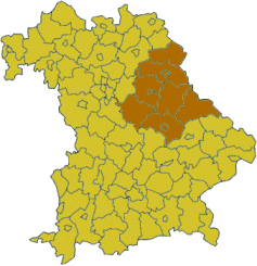
Upper Palatinate
|
|
| Statistics | |
|---|---|
| State: | Bavaria |
| Capital: | Regensburg |
| Area: | 9,692.23 km² |
| Inhabitants: | 1,088,929 (2002) |
| pop. density: | 112.35 inh./km² |
| Map | |
 | |
The Upper Palatinate (Oberpfalz) is one of the seven administrative regions of Bavaria, Germany, located in the east of Bavaria. It's subdivided into two regions (Planungsverband) - Oberpfalz-Nord and Regensburg.
The region took its name in the late middle ages, when it was one of the main portions of the territory of the Wittelsbach Elector Palatine, who also ruled over the Lower Palatinate in the Rhineland, now normally just called the Palatinate, or Pfalz. The capital of the Upper Palatinate was Amberg. Cadet branches of the Wittelsbach also ruled over smaller territories in Neuburg and Sulzbach. As a result of the Elector Palatine Frederick V's abortive claim to the Bohemian throne in 1619-20, the Upper Palatinate, along with the rest of his lands, were declared forfeit to the Emperor and, along with the Electoral title, given to the Duke of Bavaria. Although the Lower Palatinate was restored to Frederick's son by the Peace of Westphalia in 1648, the Upper Palatinate remained under the Elector of Bavaria, and has remained a part of Bavaria ever since. The smaller territories of Sulzbach and Neuburg came to Bavaria in 1742, while the city of Regensburg, an Imperial Free City, was not joined with the rest of the region until the end of the Holy Roman Empire in 1806.
| Kreise (districts) |
Kreisfreie Städte (district-free towns) |
|---|
Population
Historical Population of Upper Palatinate:
  1939:   694,742
  1950:   906,822
  1961:   898,580
  1970:   963,833
  1987:   969,868
  2002: 1,088,929
External links
- Official website (http://www.bezirk-oberpfalz.de/) (German)
- Official website of government (http://www.regierung.oberpfalz.bayern.de) (German, English, Czech)de:Regierungsbezirk Oberpfalz
