County Tyrone
|
|
| County Tyrone | |
|---|---|

| |
| Area: | 3,155 km▓ |
| Population: | 166,516 (2001 census) |
| Province: | Ulster |
- This article is about County Tyrone. For other uses of the name, see Tyrone (disambiguation).
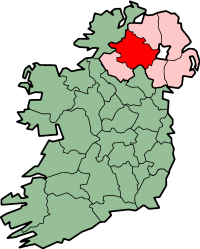
Tyrone (TÝr Eoghain) is the second largest of the nine counties of Ulster and the largest of the six counties of Northern Ireland. Area: 3,155 km▓ (1,218 square miles).
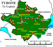
The county borders County Londonderry (Northern Ireland) to the north-east, Lough Neagh to the east, County Armagh (NI) to the south-east, County Monaghan (Republic of Ireland) to the south, County Fermanagh (NI) to the south-west and County Donegal (ROI) to the north-west.
Tyrone is split into four districts:
The county town of Tyrone is Omagh. Other towns include Castlederg and Coalisland. Historically Tyrone stretched as far north as Lough Foyle, comprising part of modern day Co. Derry, east of the Foyle river.
See the list of places in County Tyrone for all villages, towns and cities.
Template:Ireland countiesde:Tyrone (County) es:Condado de Tyrone ga:Contae ThÝr Eoghain nl:County Tyrone no:Tyrone (grevskap)

