Tikal
|
|
- This article is about the ruined city. For more uses of the word Tikal, see Tikal (disambiguation).
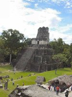
Tikal is the largest of the ancient ruined cities of the Maya civilization. It is located in the Peten region of Guatemala.
| Contents |
Tikal in the Classic era
Tikal was one of the major cultural and population centers of the Maya civilization. Monumental architecture was built here as early as the 4th century BC. The city was at its height in the Maya Classic Period, approximately 200 AD to 850 AD, after which no new major monuments were built, some of the palaces of the elite were burned, and the population gradually declined until the site was abandoned by the end of the 10th century. The name "Tikal" means "Place of Voices" or "Place of Tongues" in Maya, which may be an ancient name for the city, although the ancient hieroglyphs usually refer to it as Mutal or Yax Mutal, meaning "Green Bundle", and perhaps metaphorically "First Prophecy".
Scholars estimate that at its peak it had a population from 100,000 to 200,000.
JaguarI.jpg
The site
The site presents hundreds of significant ancient buildings, only a fraction of which have been excavated in the decades of archeological work.
The most prominent surviving buildings include six very large step pyramids supporting temples on their tops. They were numbered geographically by early explorers. They were built during the city's height from the late 7th and early 9th century. Temple I was built around 695; Temple III in 810; The largest, Temple-pyramid IV, some 72 meters (230 feet) high, was dedicated in 720. Temple V is from about 750. Temple VI was dedicated in 766.
The ancient city also has the remains of royal palaces, in addition to a number of smaller pyramids, palaces, residences, and inscribed stone monuments. There is even a building which seemed to have been a jail, originally with wooden bars across the windows and doors. There are also several courts for playing the Mesoamerican ballgame.
The residential area of Tikal covers an estimated 60 square km (23 square miles), much of which has not yet been cleared or excavated.
A huge set of earthworks has been discovered ringing Tikal, with a 6 meter wide trench behind a rampart. Only some 9km of it has been mapped; it may have enclosed an area of some 125 km square.
Ancient history of Tikal
Tikal dominated the central Maya lowlands, but was often at war. Inscriptions tell of many alliances and wars with other Maya states, including with Uaxactun, Caracol, Naranjo, and Calakmul.
Rulers
Known rulers of Tikal include:
Missing image
TempleIIILintelMaudslay.jpg
Image:TempleIIILintelMaudslay.jpg
King of Tikal from wooden lintel in Temple III
Depicting either "Yax Nuun Ayin II" or "Dark Sun"
- Yax Ehb' Xook c. 60 - dynastic founder
- Siyaj Chan K'awil Chak Ich'aak ("Stormy Sky I") 2nd century
- Yax Ch’aktel Xok c. 200
- Balam Ajaw ("Decorated Jaguar") 292
- K'inich Ehb' c. 300
- Ix Une' B'alam ("Queen Jaguar") 317
- "Leyden Plate Ruler" 320
- K'inich Muwaan Jol - died 359
- Chak Toh Ich’ak I ("Jaguar Paw I") c.360 - 378 - His palace, unusually, was never built over by later rulers, and was kept in repair for centuries as an apparent revered monument. He died on the same day that Siyah K'ak' arrived in Tikal.
- Nun Yax Ayin a noble from Teotihuacan, was installed on Tikal's throne in 379 by Siyah K'ak', ruled to 411
- Siyah Chan K'awil II ("Stormy Sky II") 411-456
- K'an-Ak ("Kan Boar") 458-486
- Ma'Kin-na Chan late 5th century
- Chak Tok Ich'aak (Bahlum Paw Skull) 486-508 married "Lady Hand"
- Ix Yo K'in ("Lady Tikal") 511-527
- Kalomte' Balam ("Curl-Head", "19th Lord") c. 511-527
- Wak Chan K'awil ("Double-Bird") - 537-562
- "Lizard Head II" - lost a battle with Caracol in 562
- K'inich Waaw 593-628
- K'inich Wayaan - early/mid 7th century
- K'inich Muwaan Jol II - early/mid 7th century
- Hasaw Chan K’awil ("Double Moon", "Lord Chocolate") 682-734 - entombed in great temple-pyramid I; his queen Lady Twelve Macaw (d. 704) is entombed in temple-pyramid II. Triumphed in war with Calakmul in 711.
- Yik’in Chan Kawil 734-766
- "Temple VI Ruler" 766-768
- Yax Nuun Ayiin II ("Chitam") 768-790
- "Dark Sun" c. 810
- "Jewel K'awil" 849
- Jasaw Chan K'awiil II 869-889
(English language names are provisional nicknames based on their identifying glyphs where rulers' Maya language names have not yet been definitively deciphered phonetically.)
Missing image
TikalNAcropStelae.jpg
Image:TikalNAcropStelae.jpg
Two stelae on the North Acropolis
Modern history of Tikal
As is often the case with huge ancient ruins, knowledge of the site was never completely lost in the region. Some second- or third-hand accounts of Tikal appeared in print starting in the 17th century, continuing through the writings of John Lloyd Stephens in the early 19th century. Due to the site's remoteness from modern towns, however, no scientific expedition visited Tikal until 1848. Several other expeditions came to further investigate, map, and photograph Tikal in the 19th and early 20th century.
In 1951 a small airstrip was built at the ruins, which previously could only be reached by several days travel through the jungle on foot or mule. From 1956 through 1970 major archeological excavations were made by the University of Pennsylvania. In 1979 the Guatemalan government began a further archeological project at Tikal, which continues to this day.
The ruins of Tikal is a World Heritage Site and can be visited by the public.
It was used as background scenery of the Rebel Base in the film Star Wars.
External links
- Tikal National Park (http://www.tikalpark.com/)
- QuickTime VR virtual tour of Tikal on destination360.com (http://www.destination360.com/tikal.htm)da:Tikal
de:Tikal es:Tikal fr:Tikal nl:Tikal ja:ティカル pl:Tikál pt:Tikal

