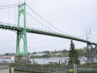
St. Johns Bridge
|
|
The St. Johns Bridge is a steel suspension bridge along U.S. 30 Bypass in Portland, Oregon that spans the Willamette River between the St. Johns neighborhood and the northwest industrial area around Linnton. It is the only suspension bridge in the Willamette Valley and one of three public highway suspension bridges in Oregon.
The bridge has two 408 ft (124 m) tall Gothic towers, a 1,207 ft (368 m) center span 205 ft (62 m) above the water, and a total length of 2,067 ft (630 m). Its two main cables are wide enough to walk on.
The bridge's engineer was David Steinman, who has said:
- It is the ethical duty of the builders to make bridges beautiful as well as useful.
By 2001, average traffic on the bridge was 23,800 vehicles/day.
| Contents |
History
At the time of the proposal to build the bridge, the area was served by a ferry which carried 1000 vehicles a day. The proposal was initially met with skepticism in Multnomah County, since St. Johns and Linnton were over five miles (8 km) from the heart of the city, and local business owners had minimal political clout. But after a lobbying effort that included a vaudeville-style show performed at grange halls and schools throughout the county, voters approved a $4.25 million bond for the bridge in the November 1928 elections. The construction of the bridge began a month before the stock market crash in October 1929 and provided many county residents with employment during the Great Depression.
Because of its proximity to the Swan Island Municipal Airport, some government officials wanted the bridge painted yellow with black stripes. County officials waited until St. Patrick's Day 1931 to announce that it would be painted green. It was dedicated on June 13, 1931 as part of the 23rd annual Rose Festival. The bridge was built within 21 months and one million dollars under budget. At the time of its completion, the bridge had
- the highest clearance in the nation,
- the longest prefabricated steel cable rope strands,
- the tallest steel frame piers of reinforced concrete, and
- longest suspension span west of Detroit, Michigan.
It was not until the Marquam Bridge in 1966 that another non-movable bridge would be built in Portland.
By the 1970s, the bridge had been allowed to deteriorate, and cash-strapped Multnomah County asked the state to take over maintenance. Initially, the state declined, since it was also suffering from a lack of funds. But pressure from an association of county governments forced the state government to take it over on August 31, 1975. A county official estimated the move saved them $10 million during the first ten years of state maintenance.
The east approaches and east span were repainted in 1994.
In 1999 the Oregon Department of Transportation announced a $27 million rehabilitation project that began in March of 2003 and is expected to be completed by the fall of 2005. Included in the project are replacement of the deck, repainting of the towers, water-proofing the main cables, lighting upgrades, and improving access for bicycle and pedestrian traffic. As of November 2004, renovation costs had soared to $38 million [1] (http://www.odot.state.or.us/region1/f_stjohns/), due mostly to the need to replace nearly half of the 210 vertical suspender cables [2] (http://www.oregonlive.com/news/oregonian/index.ssf?/base/front_page/1101387899138600.xml).
Hours of operation during construction
The St. Johns Bridge is closed from 8PM-5AM Monday-Friday until fall 2005 (projected) for renovation. The main U.S. Highway 30 route is the designated detour for US-30 Bypass, which traverses the bridge. The Portland Peninsula is accessible from Interstate 5 and N. Interstate Avenue. Locals and motorists talking on Citizen's Band Channel 17 or 19 in the area may have additional information.
Bicycle traffic is permitted on the bridge except during the hours above. However, due to lack of shoulders, high traffic flow and steep, long approaches on both sides of the bridge, crossing the St. Johns Bridge should not be attempted except by exceptionally strong cyclists able to maintain speed on a steep incline in heavy traffic. If at all possible, cyclists should take N. Willamette Avenue and SE Vera Katz Bikeway to the Steel Bridge or Hawthorne Bridge. Contact the City of Portland (http://www.portland.ci.or.us/), Metro Regional Government (http://www.metro.dst.or.us/), or Metro's Bike There! (http://www.metro-region.org/article.cfm?ArticleID=218) cycleway map for detour information.
Pedestrian traffic is prohibited. Contact TriMet (http://www.trimet.org/) for transit information. TriMet route 17 NW 21st Ave/St Helens Rd (http://www.trimet.org/schedule/r017.htm) approaches or crosses the St. John Bridge.
External links
- ODOT: St.Johns Bridge (http://www.odot.state.or.us/region1/f_stjohns/)
- Portland Bridges: St. Johns Bridge photos (http://www.portlandbridges.com/viewphotosall-D300CRW07981-18-cat-1-1.html)
- Historical Gazette: St.Johns Bridge Opening (http://www.aracnet.com/~histgaz/hgv1n3.htm)
Books
Wood, Sharon. The Portland Bridge Book. Portland: Oregon Historical Society, 2001. ISBN 0-87595-211-9.

